- Devastator Peak
-
Devastator Peak Elevation 2,327 m (7,635 ft) Prominence 67 m (220 ft) Location Location British Columbia, Canada Range Pacific Ranges Coordinates 50°35′34″N 123°31′51″W / 50.59278°N 123.53083°WCoordinates: 50°35′34″N 123°31′51″W / 50.59278°N 123.53083°W Topo map NTS 92J/12 Geology Type Volcanic plug Age of rock Pliocene Volcanic arc/belt Cascade Volcanic Arc Garibaldi Volcanic Belt Last eruption Pleistocene Climbing First ascent 1931 N. Carter; A. Dalgleish; T. Fyles; M. Winram Devastator Peak, also known as The Devastator, is the lowest and southernmost of the six subsidiary peaks that form the Mount Meager massif in southwestern British Columbia, Canada. It is located 55 km (34 mi) west of Bralorne.
Geology
Devastator Peak is a dissected andesitic volcanic plug, which was part of a larger structure of Mount Meager, but parts eroded away, leaving Devastator Peak. Like the rest of the Mount Meager massif, it is part of the Garibaldi Volcanic Belt which is a segment of the Cascade Volcanic Arc, but it is not within the geographic boundary of the Cascade Range.
Devastator Peak was the source for a thick sequence of andesite lava flows that occurred 0.5-1.0 million years ago. Erosional remnants of these flows form the stratified crags of Pylon Peak. The slopes of the peak are highly unstable, consisting of weak, hydrothermally altered felsic rocks. There have been many recent debris flows which have flowed down into the Meager Creek drainage.
See also
- List of volcanoes in Canada
- Mount Meager
- Garibaldi Volcanic Belt
- Cascade Volcanoes
- Volcanism in Canada
References
- "Devastator Peak". BC Geographical Names. http://apps.gov.bc.ca/pub/bcgnws/names/14555.html.
 Volcanoes of the Garibaldi Volcanic BeltBlack Tusk · Brew · Bridge River (Tuber · Salal Glacier · Sham) · Callaghan · Cauldron · Cayley (Pyroclastic · Vulcan's Thumb) · Cinder Cone · Ember · Fee · Franklin Glacier · Garibaldi (Atwell · Opal) · Glacier Pikes · Little Ring · Meager (Capricorn · Devastator · Job · Perkin's Pillar · Plinth · Pylon) · Monmouth Creek (The Castle) · Pali · Price (Clinker) · Ring · Round · Silverthrone (Silverthrone · Machmell River) · Slag · The Table · Tricouni Southwest · Watts PointSee also: Volcanism of Canada portal
Cascade Volcanoes British Columbia 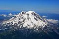
Washington Oregon California Categories:- Volcanic plugs of British Columbia
- Mountains of British Columbia
- Subduction volcanoes
- Mount Meager
- Pliocene volcanoes
- Pleistocene volcanoes
- British Columbia geography stubs

Wikimedia Foundation. 2010.