- Newberry Volcano
-
Newberry Volcano - Paulina Peak 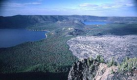
Newberry Caldera, with Paulina Lake, East Lake, and Big Obsidian FlowElevation 7,989 ft (2,435 m) NAVD 88[1] Location Location Deschutes County, Oregon, USA Range Cascade Range Coordinates 43°41′21″N 121°15′18″W / 43.689195264°N 121.254889850°WCoordinates: 43°41′21″N 121°15′18″W / 43.689195264°N 121.254889850°W[1] Topo map USGS Paulina Peak Geology Type Shield volcano with pyroclastic cones Age of rock About 600,000 years old [2] Volcanic arc/belt Cascade Volcanic Arc Last eruption 690 AD ± 100 years [3] Climbing First ascent 1873 Easiest route Road to Paulina Peak Newberry Volcano (with Newberry Caldera) is a large potentially active[2] shield volcano located 40 miles (64 km) east of the Cascade Range and about 20 miles (32 km) southeast of Bend, Oregon. It is not a typical shield volcano. In addition to erupting basaltic lavas, it also has erupted andesitic and even rhyolitic lava.
The volcano is 20 miles (32 km) in diameter and has an approximate volume of 80 cubic miles (330 km3). It possesses a large oval-shaped caldera 4 × 5 miles (6.4 × 8.0 km) in diameter, called the Newberry Caldera. Within the caldera there are two lakes (Paulina Lake and East Lake), many pyroclastic cones, lava flows, and obsidian domes.
A deep gash in the northern caldera wall, dubbed "The Fissure", is the end of a 29-mile (47 km) long series of fractures called the Northwest Rift Zone. Approximately 6,100 years ago, fissure basalt flows erupted from the rift and covered part of Newberry's northwest flank.
Newberry Volcano was named for John Strong Newberry, who explored central Oregon for the Pacific Railroad Surveys in 1855.[4]
During the Apollo program, parts of the volcano that resemble the Moon's surface were used to train the astronauts.[citation needed]
Contents
Geology
 Progression of ages of rhyolitic (silicic) lavas and calderas from McDermitt Caldera to Newberry and Yellowstone calderas (red circles: MC, NC, & YC). Numbers are ages in millions of years. KBML - Klamath—Blue Mountains Lineament, HLP - High Lava Plains, EDZ - Eugene—Denio Zone, BFZ - Brothers Fault Zone, SMF - Steens Mountain Fault, VF - Vale Fault, NNR - North Nevada Rift. White arrow shows direction of North American plate, edge of the craton is approximately along the Oregon—Idaho Border, triangles are Cascades volcanoes.
The Newberry Volcano lies at the northwest end of both the Brothers Fault Zone, and the High Lava Plains (area of blue lines on diagram at right) of volcanic features in central Oregon that have been developing since about 16 Ma. Volcanism in the High Lava Plains is bimodal, having both basaltic (mafic) and rhyolitic (silicic) types of lava. Some of the rhyolites show a progression in ages from about 10 Ma in the east to the geologically recent Newberry Caldera in the west. This track, and its implication of a moving source, roughly mirrors the similar track of the Yellowstone Hotspot from the McDermitt Caldera on the Oregon—Nevada border, on which basis the Newberry volcanism has been attributed to a so-called hotspot (a plume of hot material arising from the earth's mantle). But whereas the Yellowstone Hotspot reflects the motion of the North American plate across a hotspot, the Newberry track does not. Although the cause of the intense regional volcanism around 16 Ma is hotly debated,[5] the age progression across the High Lava Plains is now attributed to a reservoir of hot material that expanded over time, and the linearity of the trend attributed to exploitation of a deep, pre-existing weakness in the crust associated with the Brothers Fault Zone.[6]
A great deal of volcanic activity has occurred on Newberry's shield, which itself has one of the largest collections of cinder cones, domes, lava flows, and fissures in the world—so much so that local residents call these parasitic vents the "Paulina Mountains", thinking of them as a separate mountain range. Most of the cinder cones are 200 to 400 feet (60 to 120 m) high and have shallow saucer-shaped summit craters. They are typically surrounded by basalt or andesite that erupted from their bases forming large lava beds. The northern flank holds three distinct lava tube systems that formed in pāhoehoe: the Horse Lava Tube System, Arnold Lava Tube System, and the Lava Top Butte basalt.[7] On the northwest flank of the volcano is Lava Butte, located next to Highway 97 south of Bend, is a good example of this kind of cinder cone and an ʻaʻā lava bed. There are also about 20 rhyolite domes or fissures on the eastern, southern, and western flanks. Larger examples include 580,000-year-old McKay Butte on the west flank, 80,000-year-old China Hat and 850,000-year-old East Butte on the far eastern base.
During the late Pleistocene and Holocene periods, there have been six eruptive episodes. Four of them rhyolitic, on the eastern half of the caldera, and two basaltic, on the flanks.
- South Obsidian Eruptive Episode: An estimated 12,000 years ago, an obsidian dome and related obsidian flow erupted in the southeast part of the caldera.
- East Rim Eruptive Episode: About 11,200 years ago (10,000 14C years B.P.), mafic cinders, scoria, spatter, and lava flows erupted from a fissure on the east rim of the caldera.
- Interlake Eruptive Episode: A series of rhyolitic eruptions began in the caldera approximately 7,300 years ago (6,200 14C years B.P.). They produced a widespread phreatomagmatic pumiceous tephra deposit, obsidian flows, large and small pumice cones, and a pumice ring. This eruptive episode probably lasted for about 200 years.
- Northwest Rift Eruptive Episode: About 7,000 years ago (6,100 14C years B.P.), basaltic andesite lava and cinder cones erupted from extensive fissure vents on the northwest and south flanks of Newberry. Spatter and cinders also erupted from a fissure on the north caldera wall. The lava flows range up to 5.6 miles (9 km) long and are more voluminous at lower elevations. This eruptive episode probably lasted for less than 50 years.
- East Lake Eruptive Episode: About 3,500 years ago, obsidian flows and associated pumice deposits in the caldera erupted from caldera ring fractures.
- Big Obsidian Eruptive Episode: About 480 A.D. (1,470 14C years B.P.), a three-part sequence of rhyolitic eruptions began which included an air-fall tephra, ash-flow tephra, and an obsidian flow from a common vent at the base of the south caldera wall. The initial Plinian eruption 480 A.D. (1,580 14C years B.P.) produced the Newberry pumice fall deposit which blanketed the east flank of the volcano and areas to the east. About 210 years later, the Paulina Lake ash flow (1,310 14C years B.P.) spread from near the south caldera wall to Paulina Lake. The final phase of the eruption produced the Big Obsidian Flow, which covers 1.1 square miles (2.8 km2).
Newberry's highest point is located 1,500 feet (460 m) above the southern caldera floor on Paulina Peak, which is just one peak on the caldera rim. The volcano's south flank descends into the basaltic flatlands of central Oregon.
Caldera
 Map of Newberry Volcano and surroundings
Newberry Caldera has existed possibly as long as 500,000 years, when the cone of the volcano is thought to have first collapsed. Subsequent caldera-forming collapse events have further deepened the caldera but volcanic material and lake-bed sediments have largely filled in much of this depth.
Within the caldera, there are two lakes (Paulina Lake and East Lake), many cinder cones, lava flows, and obsidian domes. The land area of the caldera is often heavily forested, except in areas where there are more recent volcanic flows and features. Paulina Lake is drained by Paulina Creek, which passes through a narrow gorge through the western part of the caldera rim. East Lake does not have a known outlet and is 40 feet (12 m) higher than Paulina Lake. 6700-year-old basalt flows separate the two caldera lakes. Rising 700 feet (210 m) above this flow is the Central Pumice Cone.
Both lakes have hot springs, and drilling in 1981 found that temperatures in the caldera reach 280 °C (540 °F) at 3,057 feet (932 m) below the caldera floor. This is the highest temperature ever recorded at a dormant Cascade volcano, hotter than even The Geysers of California, the world's largest producer of geothermal power.
Newberry has had a caldera for possibly as long as 500,000 years, when a large Plinian Eruption sent so much pyroclastic material gushing from its vent that the then-emptied magma chamber collapsed. This was repeated for several eruptions; each forming a slightly smaller caldera. The half-million-year-old (estimated) Teepee Draw tuff covers much of the volcano's shield and was from an eruption with an estimated volume of 10 cubic miles (42 km3). This is thought to be the first in a series of caldera-forming eruptions that issued from Newberry's main vent system. One of the later layers is cut by Newberry's only stream, Paulina Creek.
Subsidence of the caldera through time has been partly offset by the deposition of tephra, lava flows, and lake sediment. The USGS has drilled 3,057 feet (932 m) below the present surface of the caldera and has found that:
- First 950 feet (290 m): Dominated by air-fall pumice, obsidian flows, and under-water erupted ash.
- 950–1,180 feet (290–360 m): Lake-bottom sediments.
- 1,180–1,640 feet (360–500 m): Thick layers of pumice-rich ash and breccia.
- 1,640–2,449 feet (500–746 m): Rhyolitic to dacitic lava flows.
- 2,449–3,057 feet (746–932 m): Basalt to basaltic-andesite lava flows and breccia.
There are several large flows of obsidian in the caldera, one of which, Big Obsidian Flow, was created around 1400 years ago and is thus the most recent caldera eruption. This particular flow erupted from a vent or fissure near the southern wall of the caldera and partially engulfed the Lost Lake pumice ring.
See also
- Newberry National Volcanic Monument
- Cascade Volcanoes
- Brothers Fault Zone
Notes
- ^ a b "Paulina Peak BM". NGS data sheet. U.S. National Geodetic Survey. http://www.ngs.noaa.gov/cgi-bin/ds_mark.prl?PidBox=PB0696. Retrieved 2008-11-00.
- ^ a b Sherrod & others 1997.
- ^ "Newberry". Global Volcanism Program, Smithsonian Institution. http://www.volcano.si.edu/world/volcano.cfm?vnum=1202-11-. Retrieved 2008-12-20.
- ^ McArthur & McArthur 2003.
- ^ See www.MantlePlumes.org for a taste of the debate.
- ^ Walker 1974; Walker & Nolf 1981; Jordan & others 2004; Camp & Ross 2004; Xue & Allen 2006.
- ^ Champion 2002; Donnelly-Nolan 2004; Oregon High Desert Grotto.
References
- "USFS: Newberry Volcano". http://www.fs.fed.us/r6/centraloregon/geology/info/volcanoes/newberryvol.shtml. Retrieved 2008-03-23.
- Camp, Victor E.; Ross, Martin E. (2004). "Mantle dynamics and genesis of mafic magmatism in the intermontane Pacific Northwest". J. Geophys. Res. 109 (B08204). Bibcode 2004JGRB..10908204C. doi:10.1029/2003JB002838. http://www.mantleplumes.org/WebDocuments/VicCampCRBMag.pdf.
- Champion, Duane E. (2002-05-14). "Mapping Newberry Volcano's Extensive North Flank Basalts [abstract]". http://gsa.confex.com/gsa/2002CD/finalprogram/abstract_34405.htm.
- Harris, Stephen L. (1988). Fire Mountains of the West: The Cascade and Mono Lake Volcanoes. Missoula: Mountain Press Publishing Company. ISBN 0-87842-220-X.
- Jordan, Brennan T.; Grunder, Anita L.; Duncan, Robert A.; Deino, Alan L. (2004). "Geochronology of age-progressive volcanism of the Oregon High Lava Plains: Implications for the plume interpretation of Yellowstone". J. of Geophysical Research 109 (B10202). Bibcode 2004JGRB..10910202J. doi:10.1029/2003JB002776. http://www.epssi.mtu.edu/seminar/JordanetalJGR.pdf.
- McArthur, Lewis A.; McArthur, Lewis L. (2003) [1928]. Oregon Geographic Names (Seventh ed.). Portland, Oregon: Oregon Historical Society Press. ISBN 0-87595-277-1 (trade paperback), ISBN 0-87595-278-X (hardcover).
- Donnelly-Nolan, Julie M. (2004). "Magnetic Excursion Recorded in Basalt at Newberry Volcano, Central Oregon [abstract]". http://adsabs.harvard.edu/abs/2004AGUFMGP43B0861C.
- Sherrod, D. R.; Mastin, L. G.; Scott, W. E.; Schiling, S. P. (1997). "Volcano Hazards at Newberry Volcano, Oregon". U.S. Geological Survey Open-File Report 99-311. http://vulcan.wr.usgs.gov/Volcanoes/Newberry/Hazards/OFR97-513/OFR97-513_inlined.html.
- Walker, George W. (July 1974). "Some implications of late Cenozoic volocanism to geothermal potential in the High Lava Plains of south-central Oregon". The Ore Bin 36 (7): 109–119. http://www.oregongeology.com/pubs/og/OBv36n07.pdf.
- Walker, George W.; Nolf, Bruce (1981). High Lava Plains, Brothers fault zone to Harney Basin, Oregon. In Johnston, D. A.; Donnely-Nolan, J.. "Guides to Some Volcanic Terranes in Washington, Idaho, Oregon, and Northern California". U.S. Geological Survey Circular 838: 105–111. http://www.nps.gov/history/history/online_books/geology/publications/circ/838/sec5.html.
- Xue, Mei; Allen, Richard M. (2006). "Origin of the Newberry Hotspot Track: Evidence from shear-wave splitting". Earth and Planetary Science Letters 244: 315–322. Bibcode 2006E&PSL.244..315X. doi:10.1016/j.epsl.2006.01.066. http://seismo.berkeley.edu/~rallen/pub/2005xue/XueAllenEPSL2006.pdf.
External links
- "Newberry Volcano". Geographic Names Information System, U.S. Geological Survey. http://geonames.usgs.gov/pls/gnispublic/f?p=gnispq:3:::NO::P3_FID:2026612. Retrieved 2008-11-16.
- "Paulina Peak". Geographic Names Information System, U.S. Geological Survey. http://geonames.usgs.gov/pls/gnispublic/f?p=gnispq:3:::NO::P3_FID:1147505. Retrieved 2008-11-16.
- "Newberry Caldera, Oregon". USGS Cascades Volcano Observatory. http://vulcan.wr.usgs.gov/Volcanoes/Newberry/framework.html. Retrieved 2008-03-23.
Cascade Volcanoes British Columbia 
Washington Oregon Mount Hood · Mount Jefferson · Three Sisters · Broken Top · Mount Bachelor · Newberry Volcano · Diamond Peak · Mount Thielsen · Mount Mazama (Crater Lake) · Yamsay Mountain · Mount McLoughlinCalifornia Categories:- Cascade Volcanoes
- Crater lakes
- Fissure vents
- Geology of Oregon
- Hotspot volcanoes
- Lava domes
- Lava tubes
- Mountains of Oregon
- National Natural Landmarks in Oregon
- Pyroclastic cones
- Potentially active volcanoes
- Shield volcanoes
- Subduction volcanoes
- Volcanic calderas of the United States
- Volcanoes of Oregon
- Landforms of Klamath County, Oregon
- Landforms of Deschutes County, Oregon
- Landforms of Lake County, Oregon


Wikimedia Foundation. 2010.