- Diamond Craters
-
Diamond Craters [1] 
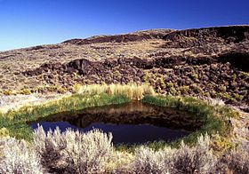
Malheur Maar, the only lake-filled maar in Diamond CratersElevation 4,708 ft (1,435 m) Location Location Harney County, Oregon, USA Range Basin and Range Coordinates 43°6′N 118°45′W / 43.1°N 118.75°W Topo map USGS Diamond Swamp Geology Type Volcanic field / shield volcano Age of rock <60,000 years [2] Last eruption Holocene? Climbing Easiest route roads and trails Diamond Craters is a volcanic field[1][2] or small shield volcano[3] in southeastern Oregon, about 40 miles (64 km) southeast of the town of Burns. It consists of a 23 sq mi (60 km2) area of basaltic lava flows, cinder cones, and maars.[2] The volcanoes are less than 60,000 years old, and some craters may be as recent as 6,000 years based on the sedimentation history in the lake-filled Malheur Maar.[1]
Diamond Craters and the nearby Diamond post office were named after the Diamond Ranch, established in the area by the pioneer Mace McCoy and his partner Albert Hugh Robie. The ranch used a diamond-shaped brand, hence the name.[4]
Notable Vents
Name Elevation Coordinates Last eruption Big Bomb Crater[5] 1,308 metres (4,291 ft) - - Central Crater Complex[5] 1,378 metres (4,521 ft) - - Cloverleaf Crater[3] - - - Dry Maar[5] 1,268 metres (4,160 ft) - - East Twin Crater[5] 1,326 metres (4,350 ft) - - Keyhole Explosion Crater[5] - - - Lava Pit Crater[5] 1,305 metres (4,281 ft) - - Little Red Cone[3] - - - Malheur Maar[5] 1,286 metres (4,219 ft) - - Nolf Crater[5] - - - Oval Crater[5] - - - Red Bomb Crater[5] 1,323 metres (4,341 ft) - - West Twin Crater[5] 1,326 metres (4,350 ft) - - References
- ^ a b c "Diamond Craters". Global Volcanism Program, Smithsonian Institution. http://www.volcano.si.edu/world/volcano.cfm?vnum=1202-17-.
- ^ a b c Wood, Charles A.; Jürgen Kienle, eds. (1990). Volcanoes of North America. Cambridge University Press. pp. 208–209. ISBN 0-512-43811-X.
- ^ a b c Peterson, Norman V.; Groh, Edward A. (1964). "Diamond Craters, Oregon". the Ore Bin 26 (2): 17–34. http://www.oregongeology.com/sub/publications/OG/OBv26n02.pdf.
- ^ McArthur, Lewis A.; Lewis L. McArthur (2003) [1928]. Oregon Geographic Names (Seventh ed.). Portland, Oregon: Oregon Historical Society Press. ISBN 0-87595-277-1 (trade paperback), ISBN 0-87595-278-X (hardcover).
- ^ a b c d e f g h i j k "Diamond Craters - Synonyms and Subfeatures". Global Volcanism Program, Smithsonian Institution. http://www.volcano.si.edu/world/volcano.cfm?vnum=1202-17-&volpage=synsub. Retrieved 2007-05-26.
External links
- Diamond Craters Outstanding Natural Area - Bureau of Land Management
- Deschutes & Ochoco National Forests - Diamond Craters
- Diamond Craters, Oregon at Volcano World
- Diamond Craters Recreation Area Management Plan
Categories:- Volcanoes of Oregon
- Volcanic fields of the western United States
- Maars of Oregon
- Crater lakes
- Landforms of Harney County, Oregon
- BLM-administered lands in Oregon
- Protected areas of Harney County, Oregon
Wikimedia Foundation. 2010.
