- Mount Tabor, Portland, Oregon
-
Coordinates: 45°30′46″N 122°35′33″W / 45.5128968°N 122.5925937°W
Mount Tabor, Portland, Oregon 
Downtown Portland, Oregon, from on Mt. Tabor Park.
Neighborhood representation Association Mount Tabor Neighborhood Association Coalition Southeast Uplift Neighborhood Program Neighborhood geography Area 4.14 km² (PDF map) Location Interactive map Demographics (2000) Population 10037 (density 2424/km²) Households 4316 (96% occupied) Owned 2808 (65%) Rented 1508 (35%) Size 2.33 persons (average) Race Distribution: White 84.6%, Asian 6.4%, Hispanic 3.5%, Black 1.3% Mount Tabor is the name of a volcanic cinder cone, the city park on the volcano, and the neighborhood of Southeast Portland that surrounds it, all in the U.S. state of Oregon. The name refers to Mount Tabor, Israel. It was named by Plympton Kelly, son of Oregon City pioneer resident Clinton Kelly.[1]
Contents
Neighborhood
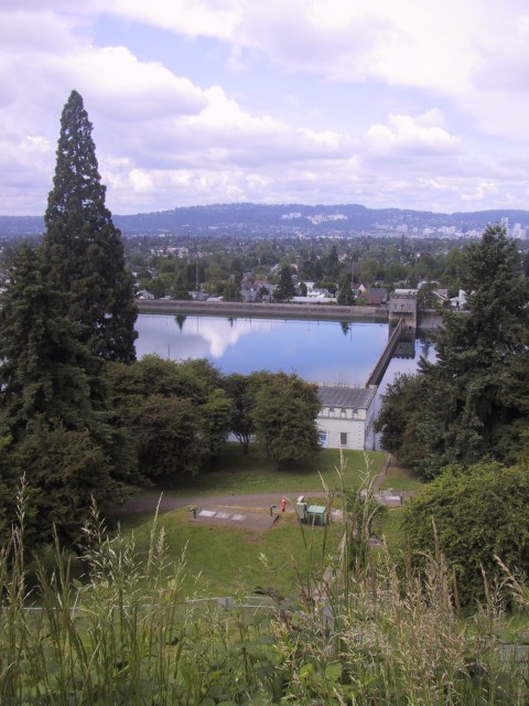
 Mount Tabor Reservoir
The Mount Tabor neighborhood lies between SE 49th Ave. (SE 50th Ave. south of SE Hawthorne Blvd.) on the west and SE 76th Ave. on the east, and between E Burnside St. on the north and SE Division St. on the south. It is bordered by Sunnyside and Richmond on the west, the North Tabor on the north and west, Montavilla on the north and east, and South Tabor on the south.
Mount Tabor Park is the neighborhood's principal feature. The campus of Warner Pacific College (affiliated with the Church of God (Anderson)) is located just south of the park. The neighborhood also marks the eastern end of the Hawthorne District. The campus of Western Seminary is located on the western slope, overlooking downtown Portland.
Before becoming part of Portland in 1905, Mount Tabor was a rural farming community dating back to the 1850s. It became a city-recognized neighborhood (encompassing a far smaller area than its historical boundaries) in 1974.[2]
See also
- Chauncey Hosford, an early owner of the property at the summit of Mt. Tabor
References
- ^ McArthur, Lewis A.; Lewis L. McArthur (2003) [1928]. Oregon Geographic Names (Seventh Edition ed.). Portland, Oregon: Oregon Historical Society Press. ISBN 0-87595-277-1 (trade paperback), ISBN 0-87595-278-X (hardcover).
- ^ "Mt Tabor Neighborhood Association - History: The early years of Mt. Tabor". Mttaborpdx.org. http://www.mttaborpdx.org/history_early_years.html. Retrieved 2008-11-04.
External links
- Mount Tabor Park in the Oregon Encyclopedia
- Mount Tabor Cinder Cone, Portland, Oregon (USGS Cascades Volcanic Observatory)
- Friends of the Reservoirs
- Friends of Mount Tabor, a non-profit group founded in 2000
- Mount Tabor: Architectural Heritage, 1850–1930 (by Jan Caplener)
- The early years of Mount Tabor (by Grant Nelson)
- Closeup of the crater, the half-circle next to the parking lot
- Audio from March 2007 news story on KPOJ, about traffic on Mount Tabor
- East Buttes, Terraces And Wetlands Conservation Plan, Bureau of Planning, Portland, Oregon (1993)
- The early years of Mt. Tabor, Mount Tabor Neighborhood Association
Volcanoes of Oregon High Cascades - Aspen Butte
- Black Butte
- Belknap Crater
- Black Crater
- Broken Top
- Diamond Peak
- Hayrick Butte
- Hogg Rock
- Hoodoo Butte
- Howlock Mtn.
- Maiden Peak
- Mt. Bachelor
- Mt. Bailey
- Mt. Hood
- Mt. Jefferson
- Mt. Mazama (Crater Lake, Wizard Island)
- Mt. McLoughlin
- Mt. Scott
- Mt. Thielsen
- Mt. Washington
- Olallie Butte
- Pelican Butte
- Three Fingered Jack
- Three Sisters
- Tumalo Mtn.
- Union Peak
Western Cascades - Boring Lava Field (Larch Mtn., Mt. Sylvania, Mt. Tabor, Powell Butte, Rocky Butte)
- Roxy Ann Peak
Eastern Cascades Basin and Range Columbia Plateau Hypothetical Categories:- Neighborhoods in Portland, Oregon

Wikimedia Foundation. 2010.