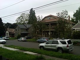
Creston-Kenilworth, Portland, Oregon

Creston-Kenilworth, Portland, Oregon
Neighborhood representation
Association Creston-Kenilworth Neighborhood Association
Coalition Southeast Uplift Neighborhood Program
Neighborhood geography
Area 2.08 km² (PDF map)
Location Interactive map
Coordinates 45°29′36″N 122°37′22″W / 45.49333°N 122.62264°W / 45.49333; -122.62264Coordinates: 45°29′36″N 122°37′22″W / 45.49333°N 122.62264°W / 45.49333; -122.62264
Demographics (2000)
Population 8234 (density 3959/km²)
Households 3514 (95% occupied)
Owned 1330 (38%)
Rented 2184 (62%)
Size 2.34 persons (average)

Creston-Kenilworth is a neighborhood in the Southeast section of Portland, Oregon, lying between SE 26th Ave. on the west and SE Foster Rd. (to SE 61st Ave.) on the east, and between SE Powell Blvd. on the north and SE Holgate Blvd. on the south. It is adjacent to the neighborhoods of Brooklyn to the west, Hosford-Abernethy, and Richmond to the north, Foster-Powell and Mt. Scott-Arleta to the east, and Reed and Woodstock to the south.

Parks include Creston Park (1920) and Kenilworth Park (1909).

According to Portland Parks & Recreation, the Kenilworth neighborhood was platted in 1889 and is "named after Sir Walter Scott's 1821 novel Kenilworth, a romantic novel set in Elizabethan England. Many of the streets in the neighborhood took their names from this novel and other novels by Scott."[1]

References

External links


Wikimedia Foundation. 2010.

Игры ⚽ Поможем сделать НИР

Look at other dictionaries:

  • Portland, Oregon — Portland   City   City of Portland Portland s skyline from the west, with Mount Hood on the left …   Wikipedia

  • Portland, Oregon neighborhoods — There are 95 officially recognized Portland, Oregon neighborhoods. Each is represented by a volunteer based neighborhood association which serves as a liaison between residents of the neighborhood and the city government, as coordinated by the… …   Wikipedia

  • Neighborhoods of Portland, Oregon — The sections of Portland. There are 95 officially recognized Portland, Oregon neighborhoods. Each Portland neighborhood is represented by a volunteer based neighborhood association which serves as a liaison between residents of the neighborhood… …   Wikipedia

  • Mount Tabor, Portland, Oregon — Coordinates: 45°30′46″N 122°35′33″W / 45.5128968°N 122.5925937°W / 45.5128968; 122.5925937 …   Wikipedia

  • Northwest District, Portland, Oregon — A shot of NW 21st Avenue, including the popular independent film theater, Cinema 21 Neighborhood representation …   Wikipedia

  • South Portland, Portland, Oregon — Neighborhood representation Association South Portland Neighborhood Association Coalition …   Wikipedia

  • Marquam Hill, Portland, Oregon — Marquam Hill is a populated hill located just south of Downtown Portland, Oregon, United States in the Homestead neighborhood. It is also called Pill Hill because it is home to Oregon Health Science University, Portland VA Medical Center and… …   Wikipedia

  • Mill Park, Portland, Oregon — Neighborhood representation Association Mill Park Neighborhood Association Coalition East Portland Neighborhood Office …   Wikipedia

  • Northwest Industrial, Portland, Oregon — Neighborhood representation Association Northwest Industrial Neighborhood Association Coalition Neighbors West/Northwest …   Wikipedia

  • North Tabor, Portland, Oregon — North Tabor Neighborhood, Portland, Oregon Neighborhood representation Association North Tabor Neighborhood Association Coalition Southeast Uplift …   Wikipedia

Share the article and excerpts

Direct link
Do a right-click on the link above
and select “Copy Link”