- Overlook, Portland, Oregon
-
Overlook, Portland, Oregon Neighborhood representation Association Overlook Neighborhood Association Coalition North Portland Neighborhood Services Neighborhood geography Area 8.58 km² (PDF map) Location Interactive map Coordinates 45°33′22″N 122°41′34″W / 45.55600°N 122.69277°WCoordinates: 45°33′22″N 122°41′34″W / 45.55600°N 122.69277°W Demographics (2000) Population 6093 (density 710/km²) Households 2462 (95% occupied) Owned 1646 (67%) Rented 816 (33%) Size 2.47 persons (average) Overlook is a neighborhood in the North section of Portland, Oregon on the east shore of the Willamette River. It borders University Park and Arbor Lodge on the north, Humboldt and Boise on the east, Eliot on the southeast, and Northwest Industrial and the Northwest District across the Willamette on the west.
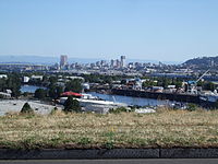 Downtown Portland with Swan Island in the foreground.
The Overlook Park Station, the N. Prescott St. Station and the N. Killingsworth Station on the MAX Yellow Line provide light rail service to the neighborhood.
Overlook House (1928) serves as a community center.[1] The Interstate Firehouse Cultural Center, next to Patton Park, features arts education, exhibits and theater.
The neighborhood includes Swan Island, originally an island in the Willamette, but connected to the east bank by landfill in the 1920s. Swan Island was the site of Portland's first airport, Swan Island Airport, dedicated by Charles Lindbergh in 1927[2] and operating until the early 1940s when the island was converted to naval shipbuilding use for World War II as one of the Kaiser Shipyards.[3] Swan Island is now an industrial area.
This neighborhood is also occasionally referred to as Mocks Crest
See also
- E. Henry Wemme, a Portland businessman credited with contributing to the development of the neighborhood.
References
- ^ Historic Overlook House - Portland's Timeless Treasure
- ^ Bui, Hien; Michelle Kain. "Little Swan Island Unable to Meet Big Changes". Archived from the original on 2007-05-07. http://web.archive.org/web/20070507032650/http://www.ccrh.org/comm/slough/airport2.htm. Retrieved 2007-01-12.
- ^ Freeman, Paul (9/3/2005). "(Original) Portland Municipal Airport / Swan Island Airport, Portland, OR". Abandoned & Little-Known Airfields. http://www.airfields-freeman.com/OR/Airfields_OR_NW.htm#swan. Retrieved 2007-01-12.
External links
- Guide to Overlook Neighborhood (PortlandNeighborhood.com)
- Overlook Neighborhood Association
- Overlook House
- Swan Island Transportation Management Association
- Swan Island in the Oregon Encyclopedia
- Historic image of Swan Island Airport from the City of Portland
Categories:- Neighborhoods in Portland, Oregon
- Multnomah County, Oregon geography stubs

Wikimedia Foundation. 2010.