- Mount Silverthrone
-
Mount Silverthrone 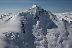
Northeast face of Mount SilverthroneElevation c. 2,865 m (9,400 ft) Prominence c. 975 m (3,200 ft) Listing List of volcanoes in Canada List of Cascade volcanoes Location Location British Columbia, Canada Range Pacific Ranges Coordinates 51°31′41.9″N 126°06′47.9″W / 51.528306°N 126.113306°W Topo map NTS 92M/09 Geology Type Lava dome Age of rock Holocene Volcanic arc/belt Cascade Volcanic Arc Pemberton/Garibaldi Volcanic Belt Last eruption Unknown; possibly younger than 1000 Climbing First ascent 1936 Don Munday, Phyllis Munday, H. Hall, Hans Fuhrer Mount Silverthrone, officially named Silverthrone Mountain, is a mountain in the Regional District of Mount Waddington, British Columbia, located over 320 km (200 mi) northwest of the city of Vancouver and about 50 km (30 mi) west of Mount Waddington, British Columbia, Canada. It is the highest peak in the Ha-Iltzuk Icefield, which is the largest icefield in the Coast Mountains south of the Alaska Panhandle.
Contents
Geology
Mount Silverthrone is an eroded lava dome on the northeast edge of a large caldera complex called the Silverthrone Caldera. It lies within the Coast Plutonic Complex, which is the single largest contiguous granite outcropping in the world. The plutonic and metamorphic rocks extend approximately 1,800 kilometers on the coast of British Columbia, southwestern Yukon and southeastern Alaska. In addition, Garibaldi, Meager, Cayley and Silverthrone areas are of recent volcanic origin. The volcanic terrain in the Silverthrone area is very similar to the Mount Meager volcanic complex further south. However, there is much more ice.
Mount Silverthrone is perhaps one the most heavily glaciated volcanic peaks in southwestern British Columbia. It has a topographic prominence of approximately 975 m (3,200 ft), greater than any other volcano in southwestern British Columbia. The extensive icefields around Mount Silverthrone are receding and are small compared to their former extent, but they are an impressive indication of how much of British Columbia looked 10,000 years or more ago. Silverthrone contains one of the few calderas buried beneath the ice caps of western Canada, another example being Mount Edziza in far northwestern British Columbia.
Skiing and recreation
The first mountaineering visit at Mount Silverthrone was by the famous pioneering climbing group of Don and Phyllis Munday in 1936 by walking up the Klinaklini Glacier from the head of Knight Inlet. Because Silverthrone is heavily glaciated, Don Munday called the mountain "home of the snows".[1]
Skiing on Mount Silverthrone includes skiing on the largest ice field in the southern Coast Mountains, the Ha-Iltzuk Icefield. It is skiable over 1,500 m (5,000 ft), possibly over 2,700 m (9,000 ft) down to the Pacific Ocean.[2] The easiest access to Mount Silverthrone is by air travel, starting from the rural community of Tatla Lake, landing on the major part of the Ha-Iltzuk Icefield. Air travels can also be made into logging camps at Owikeno Lake to the west or at the start of Knight Inlet to the southwest, followed by long hiking and skiing methods.
See also
- Cascade Volcanoes
- Garibaldi Volcanic Belt
- Pemberton Volcanic Belt
- Cascade Range
- Ha-Iltzuk Icefield
- List of volcanoes in Canada
- Volcanism of Canada
- Volcanism of Western Canada
References
- ^ Ha-Iltzuk Icefield in the Canadian Mountain Encyclopedia. Retrieved on 2007-11-13
- ^ Skiing the Pacific Ring of Fire and Beyond: Silverthrone Mountain Retrieved on 2007-11-12
External links
- Volcanoes of Canada Garibaldi Volcanic Belt (Silverthrone area)
- Catalogue of Canadian volcanoes - Silverthrone Caldera
- Silverthrone Mountain in the Canadian Mountain Encyclopedia
 Volcanoes of the Garibaldi Volcanic BeltBlack Tusk · Brew · Bridge River (Tuber · Salal Glacier · Sham) · Callaghan · Cauldron · Cayley (Pyroclastic · Vulcan's Thumb) · Cinder Cone · Ember · Fee · Franklin Glacier · Garibaldi (Atwell · Opal) · Glacier Pikes · Little Ring · Meager (Capricorn · Devastator · Job · Perkin's Pillar · Plinth · Pylon) · Monmouth Creek (The Castle) · Pali · Price (Clinker) · Ring · Round · Silverthrone (Silverthrone · Machmell River) · Slag · The Table · Tricouni Southwest · Watts Point
See also: Volcanism of Canada portal Categories:- Mountains of British Columbia
- Volcanoes of British Columbia
- Subduction volcanoes
- Lava domes
- Garibaldi Volcanic Belt
- Pacific Ranges

Wikimedia Foundation. 2010.