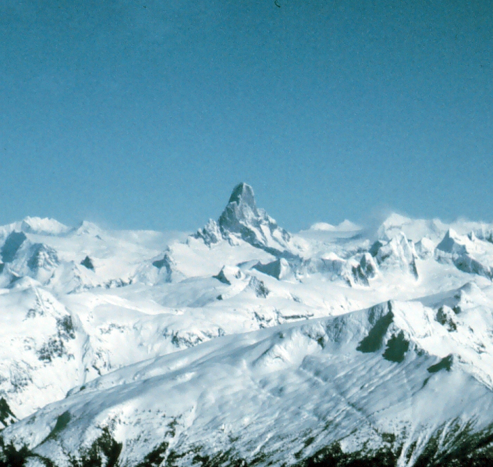
- Devils Thumb
-
For disambiguation, see Devil's Thumb (disambiguation).Not to be confused with Devils Paw, Boundary Peak 93, which is in the same mountain range.
Devils Thumb 
Elevation 9,077 ft (2,767 m) Location Location Southeastern Alaska, USA and northwestern British Columbia, Canada Range Stikine Icecap, Boundary Ranges Coordinates 57°10′26″N 132°18′05″W / 57.17389°N 132.30139°W Topo map USGS Sumdum A-2 Climbing First ascent 1946 by Fred Beckey, Clifford Schmidtke, Bob Craig Easiest route rock/snow/ice climb Devils Thumb[1], or Daalkunaxhkhu shaa in Tlingit, is a mountain in the Stikine Icecap region of the Alaska-British Columbia border, near Petersburg. It is named for its projected thumb-like appearance. Its name in the Tlingit language has the meaning "the Mountain That Never Flooded" and is said to have been a refuge for people during Aangalakhu ("the Great Flood"). It is one of the peaks that marks the border, and is also listed on maps as Boundary Peak 71.
Devils Thumb is a very challenging climb even for advanced mountain climbers. A description of the mountain can be found in Eiger Dreams, a collection of articles by Jon Krakauer, who successfully climbed the mountain early in his career. Krakauer also chronicles his solo ascent of Devils Thumb in chapters 14 and 15 of his book Into the Wild.
Contents
Location
Devils Thumb is part of a group of striking, difficult rock peaks on the western edge of the Stikine Icecap. The Stikine Icecap occupies the crest of the Boundary Ranges, a subrange of the Coast Mountains spanning the United States-Canada border, north of the mouth of the Stikine River. Other peaks in the area include the Cat's Dingleberries and Witches Tits (part of the western ridge of the Devils Thumb massif itself), and Mount Burkett and Burkett Needle, a pair of spires about 8 mi (13 km) to the northeast.
Notable features
The most famous feature on the Devils Thumb among climbers is its unclimbed Northwest Face, rising 6,700 ft (2,042 m) from the Witches Tits at its base to the summit, at an average angle of 67 degrees. This is the steepest face of this size in North America. The conditions prevalent also make it perhaps the most dangerous climbing proposition on the continent.
Climbing history
The first ascent of the Devils Thumb was a landmark in North American mountaineering. Fred Beckey, along with Clifford Schmidtke, and Bob Craig, climbed the East Ridge, a route that combined technical difficulty equal to anything ever climbed on the continent to that time with great remoteness and terrible weather conditions.
The infamous Northwest Face has seen many failed attempts starting in 1977 (possibly earlier), through the present; at least three teams have died on the face. In 1977 Jon Krakauer successfully climbed the East Ridge of the Devils Thumb.
See also
Notes
References
- Wood, Michael; Coombs, Colby (2001). Alaska: A Climbing Guide (1st ed.). Seattle: Mountaineers Books. ISBN 9780898867244. OCLC 48500987.
- Krakauer, Jon (1997) [1990]. Eiger dreams: Ventures among men and mountains (1st ed.). New York: Anchor Books. ISBN 9780385488181. OCLC 36083703.
- American Alpine Journal, 2004, 2005.
External links
- "Devils Thumb". BC Geographical Names. http://apps.gov.bc.ca/pub/bcgnws/names/25218.html.
- Devils Thumb on Topozone
- "Devil's Thumb". Bivouac.com. http://www.bivouac.com/MtnPg.asp?MtnId=3097.
Boundary Ranges Ranges Mountains Chutine · Cinder · Devils Paw · Devils Thumb · Dipyramid · Hoodoo · Ibex · Iskut Canyon · Kates Needle · King Creek · Little Bear · London · Nesselrode · Ratz · Seconed Canyon · Snippaker Creek · The VolcanoPasses Icefields Parks Atlin · Bear Glacier · Border Lake · Lava Forks · Craig Headwaters · Great Glacier · Choquette Hot Springs · Chilkoot Trail NHSC · Misty Fjords · Admiralty Island · Klondike Gold RushCategories:- Boundary Ranges
- Mountains of Alaska
- Mountains of British Columbia
- Landforms of Petersburg Census Area, Alaska
- Canada–United States border
- International mountains of North America
Wikimedia Foundation. 2010.