Stikine Icecap

Stikine Icecap

Infobox_Glacier | glacier_name = Stikine Icecap
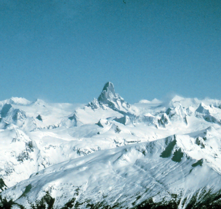


caption = The Devils Thumb rises above the Stikine Icecap
type = Icecap
location = Alaska, U.S., British Columbia, Canada
coordinates = coord|57|04|14|N|132|13|51|W|type:glacier
area =
length =
thickness =
terminus = outflow glaciers
status =
.

An extremely large icefield, the icecap is a primary source for both the Taku and Stikine Rivers. The Stikine Icecap also feeds the LeConte, Sawyer, and Great Glaciers.

The Stikine Icecap area is also renowned for its technically demanding and dangerous peaks and spires of granite that have garnered comparisons as North America's version of Patagonia [http://www.alpinist.com/climbing-notes/note/10034/] . Peaks of particular renown include Devils Thumb, Witches Tits, Cat's Ears, and the Burkett Needle.

Most expeditions into the region usually depart from Petersburg, Alaska.

Cited references

ee also

*Juneau Icefield
*List of glaciers and icefields

External links

* [http://www.bivouac.com/ArxPg.asp?ArxId=1415 Bivouac.com writeup]


Wikimedia Foundation. 2010.

Игры ⚽ Поможем написать курсовую

Look at other dictionaries:

  • Stikine Icecap — Der Devils Thumb (2.767 m) über der Stikine Icecap Die Stikine Icecap (auch Stikine Icefield genannt) ist eine 21.876 km² große Eiskappe in den Boundary Ranges der Coast Mountains. Es erstreckt sich über die Grenze zwischen Alaska und… …   Deutsch Wikipedia

  • Stikine River — Flusslauf des Stikine RiverVorlage:Infobox Fluss/KARTE fehlt Daten …   Deutsch Wikipedia

  • Stikine-Eiskappe — Der Devils Thumb über der Stikine Icecap Die Stikine Icecap (auch Stikine Icefield genannt) ist eine 21.876 km² große Eiskappe in den Boundary Ranges der Coast Mountains. Es erstreckt sich über die Grenze zwischen Alaska und der kanadischen… …   Deutsch Wikipedia

  • Stikine Icefield — Der Devils Thumb über der Stikine Icecap Die Stikine Icecap (auch Stikine Icefield genannt) ist eine 21.876 km² große Eiskappe in den Boundary Ranges der Coast Mountains. Es erstreckt sich über die Grenze zwischen Alaska und der kanadischen… …   Deutsch Wikipedia

  • Coast Mountains — Coast Range Range …   Wikipedia

  • Boundary Ranges — Geobox | Range name=Boundary Ranges other name=Alaska Boundary Range image size=275 image caption=View of the Juneau Icefield. country=Canada country1=United States region=British Columbia region1=Alaska parent=Coast Mountains geology= geology1=… …   Wikipedia

  • Devils Thumb — For disambiguation, see Devil s Thumb (disambiguation). Not to be confused with Devils Paw, Boundary Peak 93, which is in the same mountain range. Devils Thumb …   Wikipedia

  • Mount Ratz — Elevation 3,090 m (10,138 ft) Prominence 2,430 m (7,972 ft) …   Wikipedia

  • Pacific Coast Ranges — Malibu Canyon, Santa Monica Mountains The Pacific Coast Ranges (in Canada) [1] and the Pacific Mountain System (in the United States) [2] …   Wikipedia

  • Alaska Boundary Range — Lage der Boundary Ranges …   Deutsch Wikipedia

Share the article and excerpts

Direct link
Do a right-click on the link above
and select “Copy Link”