- Chilkoot Pass
-
Chilkoot Pass 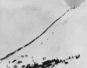
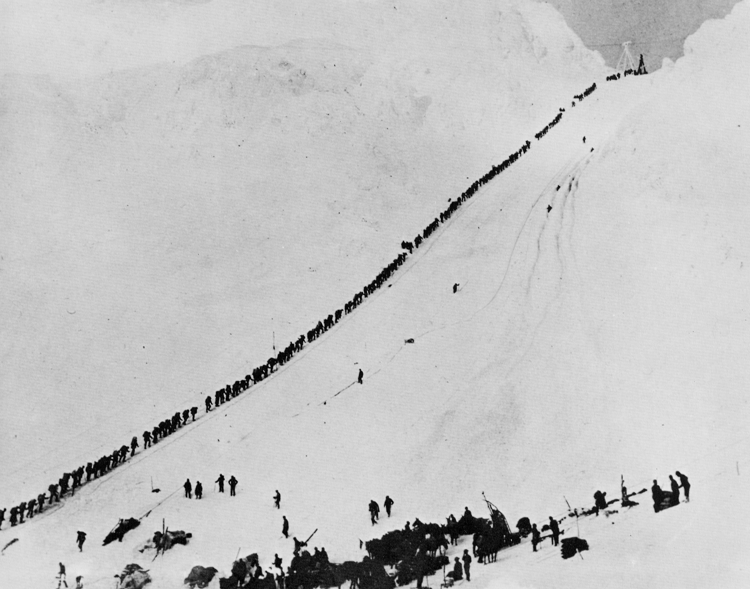
Miners climbing the Chilkoot Pass in the winter of 1897–98 during the Klondike Gold RushElevation 1,067 m (3,501 ft) Traversed by Chilkoot Trail Location Location  United States: Municipality of Skagway Borough, Alaska
 Canada: Atlin District, British Columbia
Range Boundary Ranges Coordinates 59°41′49″N 135°14′19″W / 59.69694°N 135.23861°WCoordinates: 59°41′49″N 135°14′19″W / 59.69694°N 135.23861°W Topo map NTS 104M11 Chilkoot Pass (el. 1067 m./3057 ft.) is a high mountain pass through the Boundary Ranges of the Coast Mountains in the U.S. state of Alaska and British Columbia, Canada. It is the highest point along the Chilkoot Trail that leads from Dyea, Alaska to Bennett Lake, British Columbia. The Chilkoot Trail was a route used by the Tlingit for trade and later by prospectors during the Klondike Gold Rush.
During the gold rush, three aerial tramways and several surface hoists operated briefly over the pass. When the White Pass and Yukon Route Railroad was built in neighboring White Pass, the Chilkoot Pass route fell out of favor.
The Pass and the Trail are administered by the national park services of the U.S. and Canada. On the B.C. side, it is administered as Chilkoot Trail National Historic Site.[1] On the Alaska side, it's one unit of Klondike Gold Rush National Historical Park. In the summer of 1998, the Site and the Park united to form Klondike Gold Rush International Historical Park. Modern-day visitors can hike the 33-mile trail after registering and paying a fee.
"Take the oath again, Daylight," the same voice cried. "I sure will. I first come over Chilcoot in '83. I went out over the Pass in a fall blizzard, with a rag of a shirt and a cup of raw flour. I got my grub-stake in Juneau that winter, and in the spring I went over the Pass once more. And once more the famine drew me out. Next spring I went in again, and I swore then that I'd never come out till I made my stake. Well, I ain't made it, and here I am. And I ain't going out now. I get the mail and I come right back. I won't stop the night at Dyea. I'll hit up Chilcoot soon as I change the dogs and get the mail and grub. And so I swear once more, by the mill-tails of hell and the head of John the Baptist, I'll never hit for the Outside till I make my pile. And I tell you-all, here and now, it's got to be an almighty big pile."
-
- —Jack London, Burning Daylight (1910)
See also
- Klondike Gold Rush National Historic Park (US)
References
- ^ "Chilkoot Trail National Historic Site of Canada". Parks Canada. http://www.pc.gc.ca/lhn-nhs/yt/chilkoot/natcul.aspx. Retrieved March 18, 2011.
External links
Boundary Ranges Ranges Mountains Chutine · Cinder · Devils Paw · Devils Thumb · Dipyramid · Hoodoo · Ibex · Iskut Canyon · Kates Needle · King Creek · Little Bear · London · Nesselrode · Ratz · Seconed Canyon · Snippaker Creek · The VolcanoPasses Icefields Parks Atlin · Bear Glacier · Border Lake · Lava Forks · Craig Headwaters · Great Glacier · Choquette Hot Springs · Chilkoot Trail NHSC · Misty Fjords · Admiralty Island · Klondike Gold RushCategories:- Mountain passes of British Columbia
- Mountain passes of Alaska
- Klondike Gold Rush
- Landforms of the Municipality of Skagway Borough, Alaska
- Atlin Country
- Boundary Ranges
- Canada–United States border crossings
- National Historic Sites in British Columbia
-
Wikimedia Foundation. 2010.