- Dyea, Alaska
-
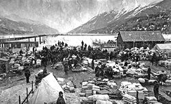
Dyea — Ghost town — The Dyea waterfront during the Klondike Gold Rush. Location within the state of Alaska Coordinates: 59°30′16″N 135°21′36″W / 59.50444°N 135.36°WCoordinates: 59°30′16″N 135°21′36″W / 59.50444°N 135.36°W Country United States State Alaska Dyea (
 /daɪˈiː/ dye-ee) is a former town in the U.S. state of Alaska. A few people live on individual small homesteads in the valley; however, it is largely abandoned. It is located at the convergence of the Taiya River and Taiya Inlet on the south side of the Chilkoot Pass within the limits of the Municipality of Skagway Borough, Alaska. During the Klondike Gold Rush prospectors disembarked at its port and used the Chilkoot Trail, a Tlingit trade route over the Coast Mountains, to begin their journey to the gold fields around Dawson City, Yukon, about 800 km (500 mi) away.
The port at Dyea had shallow water, while neighboring Skagway had deep water. Dyea was abandoned when the White Pass and Yukon Route railroad chose the White Pass Trail (instead of the alternative Chilkoot Trail), which began at Skagway, for its route.
Chilkoot Trail and Dyea Site is a U.S. National Historic Landmark.
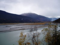
Dyea is now within the Klondike Gold Rush National Historical Park. All that remains are a number of foundations surrounded by scraps of lumber and metal, 3 cemeteries, including one where almost every person buried died on the same date in an avalanche on the gold rush trail, and the ruins of the wharf.[1] Visitors can usually spot brown bears, black bears, caribou, and eagles. Brown bears tend to use the Dyea inlets to feed during salmon spawning season (July–August).
References
- ^ nps.gov
External links
Categories:- Ghost towns in Alaska
- Klondike Gold Rush
- Geography of the Municipality of Skagway Borough, Alaska
- Alaska geography stubs
- United States ghost town stubs
Wikimedia Foundation. 2010.


