- Taiya Inlet
-
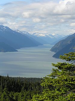 Taiya Inlet from Chilkat Peninsula
The Taiya Inlet is part of the upper Lynn Canal located in the U.S. state of Alaska. The Taiya Inlet is an estuary which lies in a deep valley, with Skagway, Alaska at its north end and the remainder of the Lynn Canal at its south end.
Contents
History
The Taiya Inlet received its name in 1868. Taiya was derived from the Tlingit term tayee, which means beneath or underneath.[1] It was also called Dayday Inlet and Dejah Inlet but the latter two names fell out of favor. The Taiya Inlet was an important waterway during the Klondike Gold Rush offering passage to the deep-water port of Skagway and, by smaller boat (due to sediment from the Taiya River), the now-ghost town of Dyea. These two boom towns were gateways to the respective White Pass and Chilkoot trails.
Taiya Inlet Winds
The winds in the Taiya Inlet are frequently diverted from their true courses by the mountains surrounding the valley in which the inlet lies. These diverted winds in the Taiya Inlet are also frequently more turbulent than the winds over the remainder of the Lynn Canal.
The Tlingits believed that the turbulent winds in the Taiya Inlet were under the control of an ill-tempered spirit known as “Kanuga.” The spirit “Kanuga” is supposedly embodied as a “rock” near the north end of the Taiya Inlet.[2] (This “rock” is apparently Face Mountain, and the spirit is now apparently called “Kanagoo.”)
Generally, the Tlingits had separate names for winds that are diverted from their true courses by mountains and valleys (as the Taiya Inlet winds are).[3] The name Skagway is derived from the Tlingit term shgagwèi, which refers to these turbulent winds in the Taiya inlet, and to the rough seas in the inlet created by these winds.[4]
Current status
Currently the Taiya Inlet is used for marine transporatation (such as the Alaska Marine Highway) and recreation such as fishing. The Taiya Inlet Watershed Council is also dedicating to its preservation.
References
- ^ Twitchell, Lance A. (2005). Lingít Dictionary. Troubled Raven Productions., at pp. 1-43 (tayee), 2-6 (beneath), 2-62 (underneath).
- ^ Krause, Aurel, and Erna Gunther (translator) (1956). The Tlingit Indians. University of Washington Press., at pp. 185, 251.
- ^ Emmons, George Thornton, and Frederica de Laguna (editor) (1991). The Tlingit Indians. University of Washington Press., at page 427.
- ^ In the past, it had been postulated that skagway or shgagwèi means home of xóon (the north wind). However, home of the north wind would be xóonani. Furthermore, Hoonah, Alaska is indirectly named after xóon.
Coordinates: 59°22′24″N 135°22′10″W / 59.37333°N 135.36944°W
Categories:- Landforms of Haines Borough, Alaska
- Klondike Gold Rush
- Inlets of Alaska
- Landforms of the Municipality of Skagway Borough, Alaska
- Southeast Alaska geography stubs

Wikimedia Foundation. 2010.