- Transvaal Colony
-
This article is about the former British colony. For other uses, see Transvaal (disambiguation).
Colony of the Transvaal British colony ← 
←1877–1881 (Suz.)
1902–1910 →
 →
→

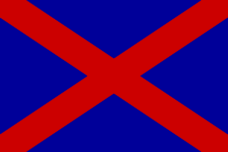
Flag Badge Location of Transvaal, ca. 1890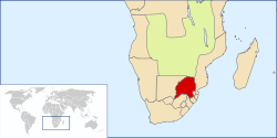
Capital Pretoria Language(s) Dutch(written)/Afrikaans(spoken)
English
Tswana
ZuluReligion Dutch Reformed, Anglican Government Constitutional monarchy King - 1902–1910 Edward VII - 1910 George V Governor - 1902–1905 Viscount Milner - 1905–1907 Earl of Selborne - 1907–1910 Hamilton John Goold-Adams Prime Minister - 1907–1910 Louis Botha Historical era Scramble for Africa - Established May 31, 1902 - Pretoria Convention 1877 - London Convention 1881 - Treaty of Vereeniging 1902 - Responsible Government 1907 - Disestablished May 31, 1910 - Union of South Africa May 31, 1910 Today part of  South Africa
The Transvaal (Afrikaans, lit. beyond the Vaal River) is the name of an area of northern South Africa. The land originally comprised most of the independent Boer South African Republic, which had existed since 1856, despite two previous attempts by the British of varying success to establish supremacy. After the Anglo-Boer War of 1899–1902 most of the land of the captured state became the Transvaal Colony, and eventually one of the initial provinces of the Union of South Africa.
Contents
History
The Transvaal was colonised by Boer settlers who left the British-dominated Cape Colony during the 1830s and 1840s in what came to be known as the Great Trek. The emigrating Boers established several republics to the north, outside British control - after the British occupation of the former Dutch colony during 1795 and again during 1806. The Great Trek was encouraged by discontent with British rule, the economic changes caused by anti-slavery laws, lack of protection against raiding Xhosa bands, and Anglicisation of established Dutch traditions. Many autonomous groups, each with its own goals, set out. Some, moving north-east, 'behind' the Nguni societies (Xhosa and Zulu), established the first independent republic, Natalia. This was soon occupied by the British during 1843 via their outpost, Port Natal, on the coast. Two years later the voortrekkers established Transoranje, (1845, later the Orange Free State). Finally, the voortrekkers migrated further north and established a number of smaller republics across the Vaal river, in the area known as the Transvaal, later to be united as the Zuid Afrikaanse Republiek (South African Republic), or ZAR.
The trekkers took advantage of the political vacuum left after the Zulu wars and their aftermath, and easily overcame the indigenous peoples. During the 1850s, the British made an agreement with the Boer republics, recognising the independence of the ZAR in what is now the Transvaal. However, during 1877 Britain annexed the ZAR as a convenient way of resolving the border dispute between the Boers and the Zulus. This also saved the Transvaal from financial ruin, as its government had little money. The Boer republic regained its independence during 1881[1] after the so-called First Boer War.
Beginning during 1885, the discovery of a tremendous lode of gold in the Witwatersrand caused the immigration of many foreigners (uitlanders) to the Transvaal. The economy of the Transvaal soon boomed. The wealth of the Transvaal state was bound to overcome the British-controlled, Boer-dominated Cape Colony, and it was speculated the Boers might eject the British from power in the region[citation needed]. Furthermore, the longer this new source of gold remained out of British control, the position of London as the main market of the world's gold trade was threatened. Using the ZAR refusal to grant Uitlander franchise as a pretext, the British therefore planned annexation of Transvaal, as a continuation of their seizure years prior of the former Orange Free State and the immense diamond fields of Kimberley therein. During 1895 foreign mine owners funded an attempted coup d'état known as The Jameson Raid. The financiers of the Raid were dissatisfied with the Boer's taxation and restrictions of business. The raid caused alarm among the Boers and resulted in massive armament, mainly from German suppliers.
Increasing fear of British designs on the Transvaal and the amassing of British forces on their borders caused the Boers to make an ultimatum to the British to decrease their forces in the region, and, when it was ignored, to war during 1899. The Second Boer War endured for three years. By the end of 1902 Britain employed 500,000 soldiers against a fighting force of approximately 64,000 Boers. Boer women and children were incarcerated in concentration camps and about 26,000 died of malnutrition, poor hygiene and disease. The British blockade and scorched earth strategy enforced through the entire Transvaal forced the Boer military commanders into submission. A defeated Transvaal was incorporated into the British Empire during 1902. The war also had immense effects on British policy domestically, within Europe and throughout the Empire. The Second Boer War made it apparent that the Empire was more vulnerable than assumed.
During 1910, the Boer republics were joined with the Cape Colony to form the Union of South Africa. Half a century later, during 1961, the union ceased to be part of the Commonwealth of Nations and became the Republic of South Africa. The PWV (Pretoria-Witwatersrand-Vereeniging) area in the Transvaal became South Africa's economic basis, a position it still has today[citation needed].
During 1994, after the end of apartheid, the former provinces were restructured, and a Transvaal district ceased to exist. The new Gauteng, Limpopo and Mpumalanga provinces lie within the borders of the old Transvaal as does most of the North West and also a small segment of KwaZulu-Natal. However, even before 1994 the Transvaal province was subdivided into regions for a number of purposes (such as for sporting divisions), into Northern Transvaal (Pretoria, and Limpopo province now), Eastern Transvaal (Mpumalanga province now), Western Transvaal (Northwest province now) and Southern Transvaal (Gauteng province now, excluding Pretoria)
The Transvaal was used as the name of a provincial division of the High Court of South Africa, until 28 February 2009.[2] The division still exists, but under a new name.
Geography
The Transvaal province lay between Vaal River in the south, and the Limpopo River in the north, roughly between 22½ and 27½ S, and 25 and 32 E. To its south it bordered with the Orange Free State and Natal provinces, to its west were the Cape Province and the Bechuanaland Protectorate (later Botswana), to its north Rhodesia (later Zimbabwe), and to its east Portuguese East Africa (later Mozambique) and Swaziland. Except on the south-west, these borders were mostly well defined by natural features.
Several Bantustans were entirely inside the Transvaal: Venda, KwaNdebele, Gazankulu, KaNgwane and Lebowa. Parts of Bophuthatswana were also in the Transvaal, with other parts in Cape Province and Orange Free State.
Within the Transvaal lies the Waterberg Massif, a prominent ancient geological feature of the South African landscape.
Divisions:
Cities in the Transvaal:
- Heidelberg
- Johannesburg
- Messina
- Nelspruit
- Pietersburg
- Pretoria
- Vereeniging
In popular culture
Frank Tashlin's 1938 Warner Bros. cartoon You're an Education shows travel brochures coming to life and doing a musical performance. Among these, the Thief of Baghdad steals some diamonds from Transvaal.
See also
- Flag of Transvaal
- History of South Africa
- South African Republic
- Transvaal civil war, 1854 conflict
References
 This article incorporates text from a publication now in the public domain: Chisholm, Hugh, ed (1911). Encyclopædia Britannica (11th ed.). Cambridge University Press.
- ^ Stephen J. Lee, Gladstone and Disraeli. Routledge, 108
- ^ De Bruin, P: "Howe se nuwe name van krag", Beeld, 8 March 2009,
External links
Administrative divisions of South AfricaCapitals: Pretoria (executive); Bloemfontein (judicial); Cape Town (legislative) Provinces Eastern Cape • Free State • Gauteng • KwaZulu-Natal • Limpopo • Mpumalanga • North West • Northern Cape • Western Cape
Municipalities Buffalo City (East London) · Cape Town · Ekurhuleni (East Rand) · eThekwini (Durban) · Johannesburg · Mangaung (Bloemfontein) · Nelson Mandela Bay (Port Elizabeth) · Tshwane (Pretoria)of the Eastern Cape · of the Free State · of Gauteng · of KwaZulu-Natal · of Limpopo · of Mpumalanga · of the North West · of the Northern Cape · of the Western Cape · Full listSettlements in the Eastern Cape · in the Free State · in Gauteng · in KwaZulu-Natal · in Limpopo · in Mpumalanga · in the North West · in the Northern Cape · in the Western CapeGriqua States and Boer Republics in Southern Africa 1795–1902  Swellendam · Graaff-Reinet · _
_  Zoutpansberg · _ Winburg ·
  Potchefstroom · Winburg-Potchefstroom · Lydenburg Republic
 Goshen ·
  Griqualand East · Griqualand West ·
  Little Republic ·
  Natalia Republic ·
  New Republic ·
  Orange Free State · Philippolis / Adam Kok's Land
 Stellaland ·
  Transvaal / South African Republic ·
  United States of Stellaland · Utrecht Republic · Waterboer's LandCategories:
- Former monarchies of Africa
- Short-lived states
- Former countries in Africa
- Former British colonies
- States and territories established in 1902
- States and territories disestablished in 1910
- Boer Republics
- Geography of South Africa
- History of South Africa


Wikimedia Foundation. 2010.