- Port Elizabeth
-
Port Elizabeth
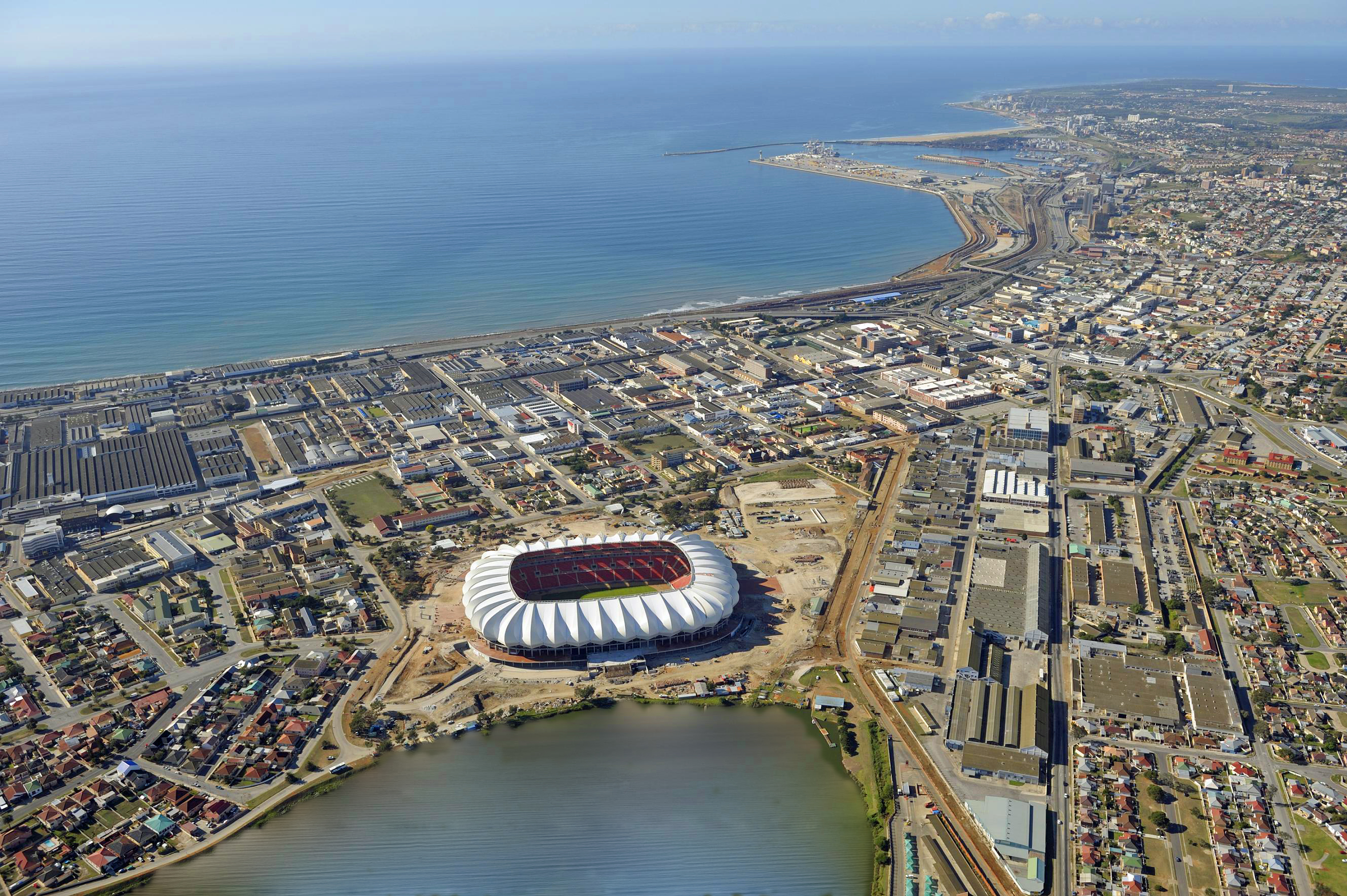
IbhayiAerial view of Port Elizabeth, Nelson Mandela Bay Stadium
Nickname(s): The Friendly City or The Windy City Location in South Africa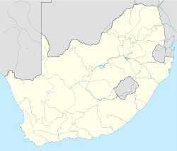
 Port Elizabeth
Coordinates: 33°57′29″S 25°36′00″E / 33.95806°S 25.6°ECoordinates: 33°57′29″S 25°36′00″E / 33.95806°S 25.6°E Country South Africa Province Eastern Cape Municipality Nelson Mandela Bay Founded 1820 Government – Executive Mayor Zanoxolo Wayile (ANC) – Municipal Manager Graham Richards Area[1][2] – City 335 km2 (129.3 sq mi) – Metro 1,959 km2 (756.4 sq mi) Population (City: 2001; Metro: 2007)[1][3] – City 237,500 – Density 709/km2 (1,836.2/sq mi) – Metro 1,050,930 – Metro density 536.5/km2 (1,389.4/sq mi) "City" population is for the Port Elizabeth Main Place in Census 2001; "Metro" population is for the NMB Metro. Time zone SAST (UTC+2) Area code(s) 041 Website http://www.mandelametro.gov.za/ Port Elizabeth (Xhosa: Ebhayi; colloquial The Bay[4] or Afrikaans: Die Baai) is one of the largest cities in South Africa, situated in the Eastern Cape Province, 770 km (478 mi) east of Cape Town. The city, often shortened to PE and nicknamed "The Friendly City" or "The Windy City", stretches for 16 km along Algoa Bay, and is one of the major seaports in South Africa. It is also referred to as Africa's Watersport Capital.[citation needed]
Port Elizabeth was founded as a town in 1820 to house British settlers as a way of strengthening the border region between the Cape Colony and the Xhosa. It now forms part of the Nelson Mandela Bay Metropolitan Municipality which has a population of over 1.3 million.
Contents
History
The area around what is now called Algoa Bay was first settled by hunting and gathering people ancestral to the San at least 100,000 years ago. A little over 2,000 years ago, agriculturalist populations ancestral to the Xhosa migrated into the region from the north, eventually displacing or assimilating the region's indigenes.
The first Europeans to have visited the area were Portuguese explorers Bartholomew Dias, who landed on St Croix Island in Algoa Bay in 1488,[5] and Vasco da Gama who noted the nearby Bird Island in 1497. For centuries, the area was simply marked on navigation charts as "a landing place with fresh water".[6]
One of the Portuguese's main goals in the Indian Ocean was to take over the lucrative trade of Arab and Afro-Arabian merchants who plied routes between the East African coast and India. As they took over that trade they established trading with their colony in India, Goa. The name, "Algoa," meant, "to Goa," just as the port further north in present day Mozambique, "Delagoa," meant, "from Goa." Algoa reflected that it was the port from which ships left for Goa during the season when the winds were favorable, while Delagoa was the port in Africa from which they arrived from Goa in the season when the winds for the return trip were favorable.
The area was part of the Cape Colony, which had a turbulent history between its founding by the Dutch East India Company in 1652 and the formation of the Union of South Africa in 1910.
 Fort Frederick
In 1799, during the first British occupation of the Colony during the Napoleonic Wars, a stone Fort was built, named Fort Frederick after the Duke of York. This fort, built to protect against a possible landing of French troops, overlooked the site of what later became Port Elizabeth and is now a monument.[6]
In 1804 the town of Uitenhage was founded[7] along the Swartkops River, a short distance inland from its estuary at Algoa Bay. Uitenhage formed part of the district of Graaff-Reinet at that time. The city of Uitenhage was incorporated in the new Nelson Mandela Metropolitan Municipality together with Port Elizabeth and the town of Despatch in 2001.
From 1814 to 1821 the Strandfontein farm, which later became the Summerstrand beach suburb of Port Elizabeth, was in possession of Piet Retief, who later became a Voortrekker leader and was killed in 1837 by Zulu king Dingane during negotiations about land. An estimated 500 men, woman and children of his party were massacred. After Retief the Strandfontein farm was owned by Frederik Korsten after whom another suburb of Port Elizabeth is named today.
In 1820 a party of 4,000 British settlers arrived by sea, encouraged by the government of the Cape Colony as a settlement would strengthen the border region between the Cape Colony and the Xhosa people. At this time the seaport town was founded by Sir Rufane Shaw Donkin, the Acting Governor of the Cape Colony, who named it after his late wife, Elizabeth. The town expanded, building a diverse community comprising European, Cape Malay and other immigrants, and particularly rapidly so after 1873 when the railway to Kimberley was built.[8] The Apostolic Vicariate of Cape of Good Hope, Eastern District, was established in the city in 1847. In 1861 the town was granted the status of autonomous municipality.
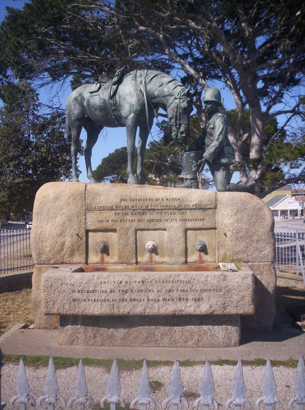
 Horse Memorial
During the Second Boer War, the port was an important transit point for soldiers, horses and materials headed to the front by railway. While the city itself did not see any conflict, many refugees from the war moved into the city. These included Boer women and children interned by the British in a concentration camp. Following that war, the Horse Memorial was erected to honour the tens of thousands of horses and mules that died during the conflict.
Apartheid era
The effects of the apartheid regime were not lost on Port Elizabeth. Forced relocation of the non-white population under the Group Areas Act began in 1962, causing various townships to be built. The whole of the South End district, being a prime real estate location, was forcibly depopulated and flattened in 1965; relocations continued until 1975.[6] In 1977 Steve Biko, the black anti-apartheid activist, was interrogated and tortured by the security police in PE, before being transported to Pretoria where he died.[9] Other notable deaths in the city during this time included the Cradock Four.
During the 1960s and 1970s the character of Port Elizabeth was changed and its face marred by two projects. The university was removed from the historical and picturesque old part of Port Elizabeth on a hill overlooking the city centre and harbour to a sandy area on the outskirts of town. The campus in town was completely inadequate. Since this removal, the old centre of Port Elizabeth has seen a slow decline. This decline was augmented by a second project, namely the building of a series of highways, viaducts and interchanges directly along the coast and over the roof of the central station thereby severing the old town from the station and harbour, destroying much of its history, integrity, allure and safety. The same system of highways also added to the damage already done by industries to the beautiful and fragile wetland area of the Swartkops estuary, one of Port Elizabeth's main natural assets.
Post apartheid
 Population density in the Nelson Mandela Metro<1 /km²1–3 /km²3–10 /km²10–30 /km²30–100 /km²100–300 /km²300–1000 /km²1000–3000 /km²>3000 /km²
Since the multiracial elections of 1994, Port Elizabeth has faced the same problems as the rest of South Africa, including Urban Decay, HIV/AIDS and a surge in violent, often drug-related, crime. However, thanks to the booming tourism[citation needed] and real estate industries, development continues apace both in the city and nearby[citation needed], for example in the new R20Billion Industrial Development Zone at Coega.
In 2001, the Nelson Mandela Bay Metropolitan Municipality was formed as an administrative area covering Port Elizabeth, the neighbouring towns of Uitenhage and Despatch and the surrounding agricultural areas. The name was chosen to honour former President Nelson Mandela. The combined metropolitan area has a population estimated at around 1.3 million as of 2006.
2010 FIFA World Cup
The Port Elizabeth harbour, waterfront and city centre were upgraded for the 2010 FIFA World Cup, and are expected to rival the popular Cape Town waterfront. The city was one of the venues for World Cup games, and many more visitors are expected now that the tournament is long finished. To this end, there are calls for Port Elizabeth Airport to be upgraded, to ease the journey time and effort for tourists.[citation needed]
Trade and industry
Home of South Africa's motor vehicle industry, Port Elizabeth boasts most vehicle assembly plants, General Motors, Volkswagen, Ford, Continental Tyres and many more automotive companies. Most other industries in the NMMM are geared towards the motor vehicle industry, providing parts such as wiring harnesses, catalytic converters, batteries and tyres to the vehicle manufacturers.
Port Elizabeth is also a major seaport, with the most significant ore loading facilities in the southern hemisphere. As part of the ongoing development, a new Industrial Development Zone with expanded port facilities is being built at Coega.
Transport
Road
Port Elizabeth lies on the N2 road. To the west the road travels the picturesque Garden Route to George and Cape Town; to the east, the road runs through the so-called Border Country through Grahamstown, to East London then on to Durban, finally terminating in Ermelo in Mpumalanga. Regional roads also connect PE with the Transkei.
The city's main bus station is in Market Square. The public bus service is run by The Algoa Bus Company.
The city is in the process of building a bus rapid transport system which was intended for the 2010 FIFA world cup. This has been suspended due to mismanagement which lead to the project missing its May 2010 deadline. Calls for the project, which has left many parts of the city in a permanent state of construction have been made recently, and it is expected that the government will make a decision on the matter soon.
Railway
Port Elizabeth railway station is served by South Africa's rail network. Local commuter services are operated by Metrorail, while the Shosholoza Meyl long-distance passenger service links PE with Johannesburg via Bloemfontein where it is possible to connect with other long-distance routes.[10]
The Apple Express narrow-gauge tourist train to Avontuur operated from the separate station in Humewood Road near King's Beach. It departed regularly for Thornhill Village via Van Stadens River bridge, the highest narrow-gauge rail bridge in the world. The Apple Express was launched to provide a service to transport fresh produce and wood from the farms along the line to Avontuur. The line was completed in 1914 and the train delivered produce directly from the farms to ships in the Port Elizabeth Harbour. Service has now ceased.
In preparation for the 2010 World Cup Soccer event the Humerail Station was extensively upgraded. Several disused narrow gauge goods wagons were scrapped and removed from the site, several buildings in the area have also been renovated and revamped.
Due to modern transport methods and containerisation and refrigerated containers and trucks the Apple Express and its services became redundant.
Air
Port Elizabeth Airport (IATA airport code PLZ, ICAO airport code FAPE) serves the city for both passenger and cargo traffic. It is the fourth busiest airport in South Africa after Johannesburg International, Durban International and Cape Town International.
International visitors to the city must currently fly to either Johannesburg or Cape Town and then take a domestic flight to Port Elizabeth. An upgrade to the terminal building, completed in 2004, created the necessary facilities to handle international flights[11] although none are scheduled as yet.
The general aviation sector is well represented in PE, with a number of facilities on-field able to provide aircraft charter and rental, handling, maintenance and training to commercial level. There are also a few smaller airfields in the vicinity. Port Elizabeth has one of the best flight schools in Africa.
Sea
Port Elizabeth has a harbour in Algoa Bay, and construction of a second seaport is underway. The newer international harbour at Coega will support an increase in the size of the city's industries and the addition of new industries.
Geography and climate
Port Elizabeth Climate chart (explanation) J F M A M J J A S O N D 3625184025185425175823145922126220947209642010622011592113492215342416Average max. and min. temperatures in °C Precipitation totals in mm Source: SAWS[12] Imperial conversion J F M A M J J A S O N D 1.477641.677642.177632.373572.372542.468481.968482.568502.468522.370551.972591.37561Average max. and min. temperatures in °F Precipitation totals in inches "The Windy City" has a subtropical climate with light rain throughout the year. Under the Koppen climate classification, Port Elizabeth has an oceanic climate. The area lies between the winter rainfall, Mediterranean climate zones of the Western Cape and the summer rainfall regions of eastern South Africa. Winters are cool but mild and summers are warm but considerably less humid and hot than more northerly parts of South Africa's east coast.[13]
Climate data for Port Elizabeth Month Jan Feb Mar Apr May Jun Jul Aug Sep Oct Nov Dec Year Record high °C (°F) 39
(102)38
(100)41
(106)39
(102)35
(95)32
(90)33
(91)34
(93)39
(102)39
(102)36
(97)36
(97)41
(106)Average high °C (°F) 25
(77)25
(77)25
(77)23
(73)22
(72)20
(68)20
(68)20
(68)20
(68)21
(70)22
(72)24
(75)22 Average low °C (°F) 18
(64)18
(64)17
(63)14
(57)12
(54)9
(48)9
(48)10
(50)11
(52)13
(55)14
(57)16
(61)14 Record low °C (°F) 10
(50)11
(52)8
(46)4
(39)2
(36)−1
(30)−1
(30)2
(36)2
(36)3
(37)6
(43)9
(48)−1
(30)Precipitation mm (inches) 36
(1.42)40
(1.57)54
(2.13)58
(2.28)59
(2.32)62
(2.44)47
(1.85)64
(2.52)62
(2.44)59
(2.32)49
(1.93)34
(1.34)624
(24.57)Avg. precipitation days 9 9 10 9 9 8 8 10 9 11 11 9 112 Source: South African Weather Service[12] Sport
The city has a wealth of fine sporting facilities, catering for cricket, rugby union, association football, field hockey and many other sports. Its coastal location also makes it a base for many watersports.
Port Elizabeth is the location of the St George's Park cricket ground, which holds test cricket matches. St George's Park is also the oldest cricket ground in South Africa, and was the venue for the first Test match played outside of Australia or England, between South Africa and England on the 12 and 13 March 1889. The Warriors, a top Cricket Team in South Africa, is based in Port Elizabeth.
The headquarters of the controversial Southern Spears rugby franchise was in Port Elizabeth. The long-standing Eastern Province Rugby Union, now commonly known as the Eastern Province Kings, would form the basis of the Spears franchise together with East London's Border Bulldogs. The remnants of the Spears were later reconstituted into the Southern Kings, also based in Port Elizabeth, which are now tentatively scheduled to join Super Rugby in 2013. The union, although still headquartered at EPRU Stadium, now play their home matches at Nelson Mandela Bay Stadium, built for the 2010 FIFA World Cup.
In December 2011, Nelson Mandela Bay Stadium will become the new home of the South Africa Sevens, the country's leg of the annual IRB Sevens World Series in rugby sevens. The event had been held in George in the Western Cape from 2002 to 2010,
The city's main football club is Bay United. They have previously played in the Premier Soccer League, but currently play in the National First Division. They currently use the EPRU Stadium for their home games.
The Algoa Bay Yacht Club operated out of Port Elizabeth harbour.
Tourism
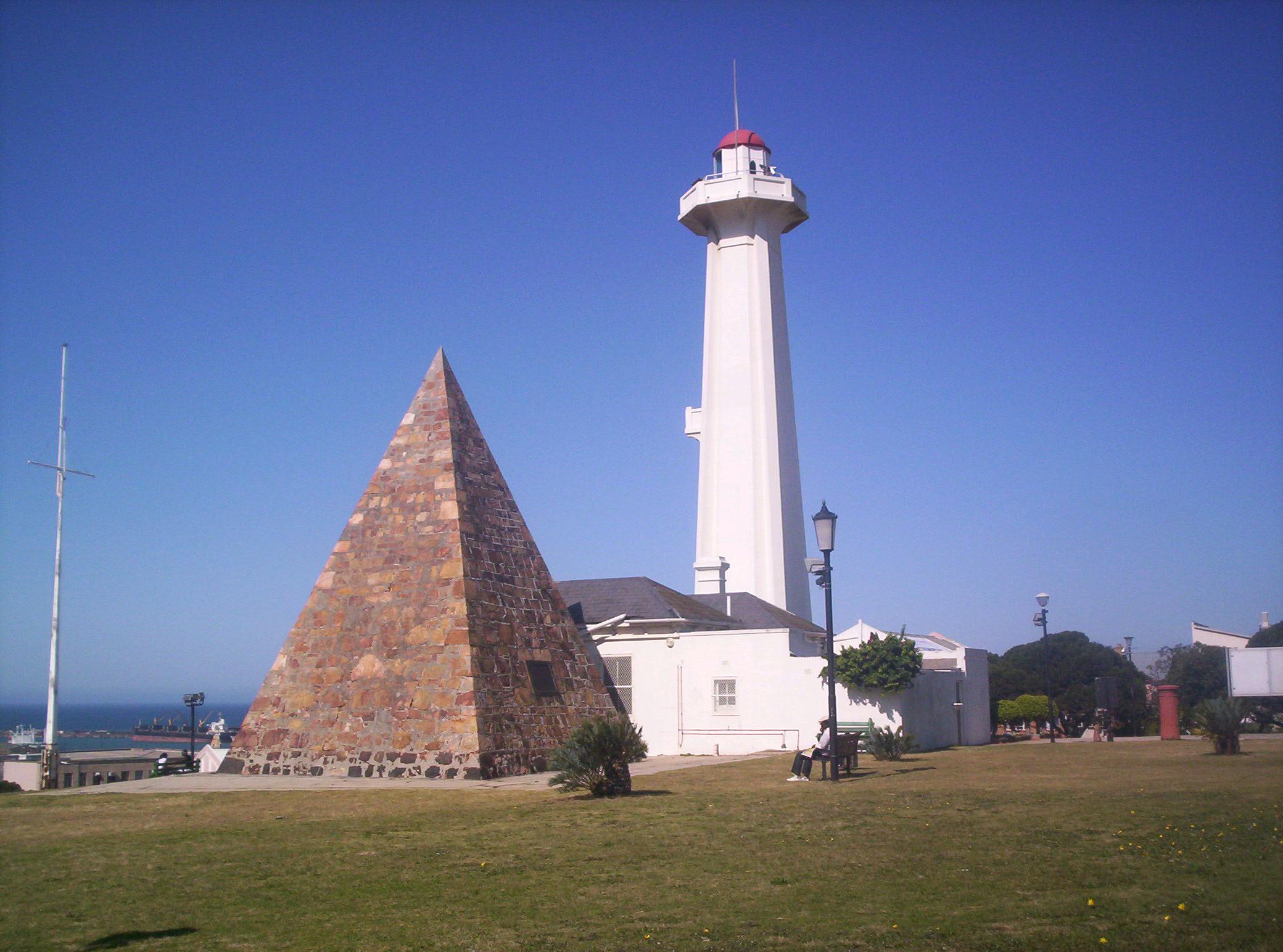
 The Donkin Reserve
Located at the end of the picturesque Garden Route along the Cape coast, the city is one of South Africa's major destinations for tourists, many of whom come simply to enjoy the many fine beaches in and near the city.
The area surrounding the CBD has a number of historic attractions, many of which are linked by the Donkin Heritage Trail. These include the Campanile (bell tower), built in 1923 to commemorate the arrival of the 1820 Settlers and offering a great viewpoint over the city; the city hall (1862); the Donkin Reserve park and monument; and the old stone Fort Frederick itself (1799). The CBD also boasts the towering Eastern Cape post office headquarters.
Other attractions include the gardens at St George's Park, the Nelson Mandela Metropolitan Art Museum (formerly known as the King George VI Art Gallery), the museum and oceanography room at Humewood, and the new Boardwalk waterfront complex.
The wider area surrounding PE also features a number of game viewing opportunities, including the famous Addo Elephant Park, 72 km to the north near the Zuurberg mountain range and National Park.
Port Elizabeth is known commonly as the watersports capital of South Africa and home of the Ironman of Africa. Algoa bay is home to scuba diving, game fishing charters, surfing, windsurfing, kiteboarding to name but a few. There are many cruises offered from the harbour from sunset cruises to view dolphins to whale watching tours. More tourism information available at www.nmbt.co.za.
Education
The Nelson Mandela Metropolitan University (NMMU) was formed in 2005 by the amalgamation of the University of Port Elizabeth, Port Elizabeth Technikon, and the Port Elizabeth campus of Vista University. It is the largest university in the Eastern and Southern Cape, with around 24,000 students in seven faculties spread over eight campuses.
The city has a number of top government-funded and private schools, including Alexander Road High School,[14] Collegiate Girls' High School, Grey High School,[14][15] Pearson High School[14] and Woodridge College[citation needed].
Government
Port Elizabeth forms part of the Nelson Mandela Bay Metropolitan Municipality, and serves as the seat for the surrounding Cacadu District Municipality. Port Elizabeth is a seat of the Eastern Cape High Court, as well as a Magistrate's Court. As a result of the presence of a High Court, several other related organs of state such as a Masters Office and a Director of Public Prosecutions are present in the city. A few other Government (mostly provincial) departments maintain branches or other offices in Port Elizabeth.
Notable people
- Johan Botha – Cricketer
- Schalk Burger – Rugby union player; 2004 IRB International Player of the Year
- Adrienne Camp – Singer/songwriter
- Thinus Delport – Rugby union player
- Danie Gerber – Rugby union player
- Rodney Howard-Browne – Charismatic Christian evangelist in the U.S.
- Danny Jordaan – 2010 FIFA world cup organising committee boss
- Len Killeen – Rugby union player
- Zolani Mahola – Actress and singer/songwriter with the band Freshlyground
- Joe van Niekerk – Rugby union player
- Wayne Parnell – Cricketer
- Robin Peterson – Cricketer
- Shawn Phillips – Singer/songwriter
- Graeme Pollock – Cricketer
- Peter Pollock – Cricketer
- Shaun Pollock – Cricketer
- Ashwell Prince – Cricketer
- Mzwandile Stick – Rugby union player; former captain of the national sevens team
- Peter Church - Writer
See also
References
- ^ a b "Main Place 'Port Elizabeth'". Census 2001. http://census.adrianfrith.com/place/27516. Retrieved 1 April 2011.
- ^ "Nelson Mandela Bay Metropolitan Municipality". Municipal Demarcation Board. http://www.demarcation.org.za/PortalPages/info_1.aspx?type=Metropolitan&Prov=Eastern%20Cape&code=NMA. Retrieved 25 June 2010.
- ^ "Community Survey, 2007: Basic Results Municipalities" (PDF). Statistics South Africa. http://www.statssa.gov.za/Publications/P03011/P030112007.pdf. Retrieved 25 June 2010.
- ^ Pettman, Charles (1913). Africanderisms; a glossary of South African colloquial words and phrases and of place and other names. Longmans, Green and Co.. pp. 51. http://www.archive.org/stream/cu31924026563795#page/n71/mode/2up.
- ^ "1911 Encyclopaedia Britannica article". Love To Know. http://www.1911encyclopedia.org/Algoa_Bay.
- ^ a b c "Nelson Mandela Bay Tourism – Historical information". Nelson Mandela Bay Tourism. http://www.nmbt.co.za/attractions/history.asp.
- ^ Sellick, W.S.J. (1904). Uitenhage, past and present : souvenir of the Centenary, 1804–1904. pp. 10. http://www.archive.org/details/uitenhagepastpre00sell.
- ^ "Info Please article". Info Please. http://www.infoplease.com/ce6/world/A0839779.html.
- ^ "Biography of Steve Biko". about.com African History. http://africanhistory.about.com/library/biographies/blbio-stevebiko.htm.
- ^ "Shosholoza Meyl". Spoornet. http://www.spoornet.co.za/ShosholozaMeyl/index.jsp.
- ^ "Introduction and History of Port Elizabeth Airport". Airports Company of South Africa. http://www.airports.co.za/home.asp?pid=1183.
- ^ a b "Climate data for Port Elizabeth". South African Weather Service. June 2011. http://old.weathersa.co.za/Climat/Climstats/PortElizabethStats.jsp. Retrieved 6 March 2010.
- ^ "Rainfall". Falling Rain. http://www.fallingrain.com/world/SF/1/Port_Elizabeth.html.
- ^ a b c SA's Top Schools 17 Oct 2009
- ^ "The 100 best high schools in Africa, 2003." Africa Almanac. Retrieved 21 Nov 2009.
External links
- Nelson Mandela Bay Municipality
- Port Elizabeth Regional Chamber of Commerce and Industry
- Nelson Mandela Bay (Port Elizabeth) Tourism Board

Province of Eastern Cape, South Africa Metropolitan
MunicipalitiesDistrict
and Local
MunicipalitiesCamdeboo · Blue Crane Route · Ikwezi · Makana · Ndlambe · Sunday's River Valley · Baviaans · Kouga · Kou-KammaCategories:- Cities in South Africa
- Port cities in South Africa
- Ports and harbours of South Africa
- Populated coastal places in South Africa
- Populated places in the Eastern Cape
- Indian Ocean
- Nelson Mandela Municipality
- Port Elizabeth
- 1820 in South Africa
- Populated places established in 1820


Wikimedia Foundation. 2010.