- Nkonkobe Local Municipality
-
Nkonkobe Local Municipality — Local municipality — Location in the Eastern Cape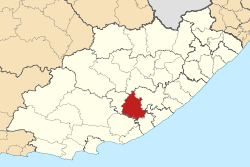
Country South Africa Province Eastern Cape District Amatole District Seat Fort Beaufort Area - Total 3,724 km2 (1,437.8 sq mi) Population (2007)[1] - Total 130,100 - Density 34.9/km2 (90.5/sq mi) - Households 34,890 Racial makeup[2] (2007) - Black African 95.30% - White 0.27% - Coloured 4.43% - Indian or Asian 0.01% Time zone SAST (UTC+2) Municipal code EC127 Nkonkobe Local Municipality is an administrative area in the Amatole District of the Eastern Cape in South Africa. The municipality is named after a mountain range (Winterberg), Nkonkobe in isiXhosa.[3]
References
- ^ "Community Survey, 2007: Basic Results Municipalities" (PDF). Statistics South Africa. http://www.statssa.gov.za/Publications/P03011/P030112007.pdf. Retrieved 2009-10-20.
- ^ "Community Survey 2007 interactive data". Statistics South Africa. http://www.statssa.gov.za/community_new/content.asp?link=interactivedata.asp. Retrieved 19 October 2009.
- ^ South African Languages - Place names
Province of Eastern Cape, South Africa Metropolitan
MunicipalitiesDistrict
and Local
MunicipalitiesCamdeboo · Blue Crane Route · Ikwezi · Makana · Ndlambe · Sunday's River Valley · Baviaans · Kouga · Kou-KammaCategories:- Local Municipalities of Amatole

Wikimedia Foundation. 2010.