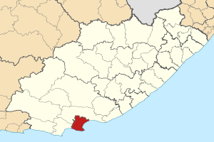
- Nelson Mandela Bay Metropolitan Municipality
-
Nelson Mandela Bay Municipality — Municipality — Location in the Eastern Cape Coordinates: 33°57′29″S 25°36′00″E / 33.95806°S 25.6°ECoordinates: 33°57′29″S 25°36′00″E / 33.95806°S 25.6°E Country South Africa Province Eastern Cape Incorporated 2001 Government – Executive Mayor Cllr Zanoxolo Wayile[1] – Municipal Manager Graham Richards Area[2] – Total 1,950 km2 (752.9 sq mi) Population (2007)[2] – Total 1,050,930 – Density 570/km2 (1,475/sq mi) – Households 276,881 Racial makeup(2007)[3] – Black African 60.4% – Coloured 22.6% – White 16.1% – Indian or Asian 0.9% Languages(2001)[4] – isiXhosa 57.3% – Afrikaans 29.7% – English 12.1% Time zone SAST (UTC+2) Municipal code NMA Website http://www.mandelametro.gov.za/ Nelson Mandela Bay Municipality is one of six Metropolitan (or Category A) municipalities in South Africa. It is located on the shores of Algoa Bay in the Eastern Cape province, and comprises the city of Port Elizabeth, the nearby towns of Uitenhage and Despatch, and the surrounding rural area.
The name "Nelson Mandela Bay Municipality" was chosen to honour former President Nelson Mandela, although there is no geographical feature in the area by that name.
Contents
History
In 2001, the Nelson Mandela Bay Metropolitan Municipality was formed as an administrative area covering Port Elizabeth, the neighbouring towns of Uitenhage and Despatch and the surrounding agricultural areas.
Demographics and statistics
As of the census of 2001,[5] there are 1,005,776 people and 260,798 households in the Nelson Mandela Bay Metropolitan Municipality. The official estimate of population in 2007 was 1,050,930.
In the 2007 census, 60.4% of respondents described themselves as Black African, 22.6% Coloured, 16.1% White and 0.9% Indian/Asian.
The largest religious groupings are Christian (89.4% of residents), No Religion (6.1%), Muslim (1.5%), Jewish (0.4%) and Hindu (0.3%).
57.3% of the residents speak IsiXhosa as their mother tongue. Afrikaans is the mother tongue of 29.7%, and English, 12.1%.
- 16.0% of all households are single-person.
- The average household size is 3.86.
- The median age is 26 years.
- For every 100 females there are 91.2 males.
- 28.2% of the population aged 15–65 is unemployed.
- The median annual income of working adults aged 15–65 is ZAR 21 837 ($3,282).
According to the 2009 edition of the municipality's 2006-2011 Integrated Development Plan, manufacturing is the single largest contributor to the local economy (33%), followed by community services (27%). Tourism represents a key sector of the economy that has increasingly contributed to job creation in recent years, thanks in large part to the municipality's seaside location and its abundance of unspoiled beaches, of which four carry Blue Flag status.[6]
100% of households have access to a source of water within a 200 m radius. 91% of households have access to a basic level of sanitation. 100% of households within the urban boundary have access to a basic level of solid waste removal, and 97% of households in formally demarcated municipal residential areas have access to a basic level of electricity. The municipality has 41 permanent and satellite clinics, 13 mobile clinics, eight hospitals, 22 libraries, 31 community and municipal halls, 79 sports facilities, 19 beaches, 18 pools, 273 schools, one university (the Nelson Mandela Metropolitan University), four technical colleges and two Further Education and Training institutions.[6]
Government
The Nelson Mandela Bay Municipality is governed by a 120-member council, and is divided into 60 electoral wards.[7]
Notes
- ^ "Cities Leadership Timeline". State of the Cities Report 2011. South African Cities Network. http://www.sacities.net/images/stories/2011/pdfs/report_launch_4.pdf. Retrieved 23 May 2011.
- ^ a b "Vital Statistics". Nelson Mandela Metropolitan Municipality. http://www.mandelametro.gov.za/default.aspx?page=30211.
- ^ "Community Survey 2007 interactive data". Statistics South Africa. http://www.statssa.gov.za/community_new/content.asp?link=interactivedata.asp. Retrieved 19 October 2009.
- ^ "Census 2001 interactive data". Statistics South Africa. http://www.statssa.gov.za/census01/html/C2001Interactive.asp. Retrieved 19 October 2009.
- ^ "Census 2001 home page". Statistics South Africa. http://www.statssa.gov.za/census01/html/default.asp.
- ^ a b "Integrated Development Plan 2006–2011 of the Nelson Mandela Bay Metropolitan Municipality, 8th edition". Nelson Mandela Bay Municipality. http://www.nelsonmandelabay.gov.za/Content.aspx?objID=357. Retrieved Oct 17, 2009.
- ^ 28/02/05 Notice 67 Gazette 1317. Municipal Demarcation Board. February 28, 2005. Retrieved October 17, 2009.
See also
External links
Province of Eastern Cape, South Africa Provincial Capital: BhishoMetropolitan
MunicipalitiesBuffalo City · Nelson Mandela BayDistrict
and Local
MunicipalitiesCamdeboo · Blue Crane Route · Ikwezi · Makana · Ndlambe · Sunday's River Valley · Baviaans · Kouga · Kou-KammaInxuba Yethemba · Tsolwana · Inkwanca · Lukhanji · Intsika · Emalahleni · Engcobo · SakhisizweElundini · Senqu · Maletswai · GariepCategories:- Nelson Mandela Municipality
- Metropolitan Municipalities of South Africa
- Populated coastal places in South Africa
Wikimedia Foundation. 2010.


