- Nxuba Local Municipality
-
Nxuba Local Municipality — Local municipality — Location in the Eastern Cape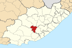
Country South Africa Province Eastern Cape District Amatole District Seat Adelaide Area - Total 2,732 km2 (1,054.8 sq mi) Population (2007)[1] - Total 21,467 - Density 7.9/km2 (20.4/sq mi) - Households 6,277 Racial makeup[2] (2007) - Black African 75.10% - White 6.12% - Coloured 18.72% - Indian or Asian 0.07% Time zone SAST (UTC+2) Municipal code EC128 Nxuba Local Municipality is an administrative area in the Amatole District of the Eastern Cape in South Africa. The Fish River, as it is now called, was first named Nxuba River by King Sandile in the 18th century[3]
References
- ^ "Community Survey, 2007: Basic Results Municipalities" (PDF). Statistics South Africa. http://www.statssa.gov.za/Publications/P03011/P030112007.pdf. Retrieved 2009-10-20.
- ^ "Community Survey 2007 interactive data". Statistics South Africa. http://www.statssa.gov.za/community_new/content.asp?link=interactivedata.asp. Retrieved 19 October 2009.
- ^ South African Languages - Place names
Province of Eastern Cape, South Africa Provincial Capital: Bhisho Metropolitan
MunicipalitiesDistrict
and Local
MunicipalitiesCamdeboo · Blue Crane Route · Ikwezi · Makana · Ndlambe · Sunday's River Valley · Baviaans · Kouga · Kou-KammaCategories:- Local Municipalities of Amatole

Wikimedia Foundation. 2010.