- Eastern Cape
-
Eastern Cape
Oos-Kaap (Afrikaans)
Mpuma-Kapa (Xhosa)— Province of South Africa — The Province of the Eastern Cape 
Coat of armsMotto: Development through Unity Location of the Eastern Cape in South Africa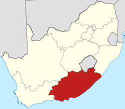
Country  South Africa
Established 27 April 1994 Capital Bhisho Districts List- Nelson Mandela Bay
- Cacadu
- Amatole
- Chris Hani
- Joe Gqabi
- OR Tambo
- Alfred Nzo
Government – Type Parliamentary system – Premier Noxolo Kiviet (ANC) Area[1] – Total 168,966 km2 (65,238.1 sq mi) Area rank 2nd in South Africa Highest elevation 3,019 m (9,905 ft) Lowest elevation 0 m (0 ft) Population (2007)[2][3] – Total 6,527,747 – Estimate (2010) 6,743,800 – Rank 3rd in South Africa – Density 38.6/km2 (100.1/sq mi) – Density rank 6th in South Africa Population groups[4] – Black African 87.6% – Coloured 7.5% – White 4.7% – Indian or Asian 0.3% Languages[5] – Xhosa 83.7% – Afrikaans 9.6% – English 3.7% – Sotho 2.5% Time zone SAST (UTC+2) ISO 3166 code ZA-EC Website www.ecprov.gov.za The Eastern Cape is a province of South Africa. Its capital is Bhisho, but its two largest cities are Port Elizabeth and East London. It was formed in 1994 out of the "independent" Xhosa homelands of Transkei and Ciskei, together with the eastern portion of the Cape Province. Landing place and home of the 1820 settlers, the central and eastern part of the province is the traditional home of the Xhosa people. This region is the birthplace of many prominent South African politicians, such as Nelson Mandela, Oliver Tambo, Walter Sisulu, Govan Mbeki, Raymond Mhlaba, Chris Hani, Thabo Mbeki, Steve Biko and Charles Coghlan.
Contents
History
The Eastern Cape as a South African Province came into being in 1994 and incorporated areas from the former Xhosa homelands of the Transkei and Ciskei, together with what was previously part of the Cape Province. This resulted in several anomalies including the fact that the Province has four superior courts (at Grahamstown, Port Elizabeth, Bhisho and Mthatha) and enclaves of Kwa-Zulu Natal in the province. The latter anomaly has fallen away with the amendments to municipal and provincial boundaries.
Law and Government
Main article: Politics of the Eastern CapeThe first premier was Raymond Mhlaba of the African National Congress and current premier of Eastern Cape province is Noxolo Kiviet of the African National Congress.
Geography
The Eastern Cape gets progressively wetter from west to east. The west is mostly semi-arid Karoo, except in the far south, which is temperate rainforest in the Tsitsikamma region. The coast is generally rugged with interspersed beaches. Most of the province is hilly to very mountainous between Graaff-Reinet and Rhodes including the Sneeuberge (English: Snow Mountains), Stormberge, Winterberge and Drakensberg (English: Dragon Mountains). The highest point in the province is Ben Macdhui at 3001m. The east from East London towards the Kwa-Zulu Natal border – a region known as Transkei – is lush grassland on rolling hills, punctuated by deep gorges with intermittent forest.
Eastern Cape has a shoreline in the south on the South Indian Ocean. In the northeast, it borders the following districts of Lesotho:
- Mohale's Hoek – west of Quthing
- Quthing – between Mohale and Qacha's Nek
- Qacha's Nek – east of Quthing
Domestically, it borders the following provinces:
- Western Cape – west
- Northern Cape – northwest
- Free State – north
- KwaZulu-Natal – far northeast
Climate
Climate is highly varied. The west is dry with sparse rain during winter of summer, with frosty winters and hot summers. The Tsitsikamma to Grahamstown receives more precipitation, which is also relatively evenly distributed and temperatures are mild. Further east, rainfall becomes more plentiful and humidity increases, becoming more subtropical along the coast with summer rainfall. The interior can become very cold in winter, with heavy snowfalls occasionally occurring in the mountainous regions between Molteno and Rhodes.
- Port Elizabeth: Jan Max: 25 °C, Min: 18 °C; Jul Max: 20 °C, Min: 9 °C
- Molteno & Barkly East: Jan Max 28 °C, Min 11 °C; Jul Max: 14 °C, Min: -7 °C
Tourism
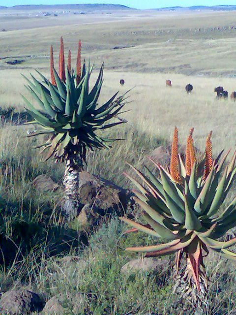
 Aloe ferox on the R61 route between Cofimvaba and Ngcobo.
The landscape is extremely diverse. The western interior is largely arid Karoo, while the east is well-watered and green. The Eastern Cape offers a wide array of attractions, including 800 km of untouched and pristine coastline along with some particularly splendid beaches, and "big-five" viewing in a malaria-free environment.
The Addo Elephant National Park, situated 73 km from Port Elizabeth, was proclaimed in 1931. Its 743 km² offers sanctuary to 170 elephants, 400 Cape buffalo and 21 black rhino of the very scarce Kenyan sub-species.
The province is the location of South Africa's only ski resort, Tiffindell, which is situated near the hamlet of Rhodes in the Southern Drakensberg on the slopes of the highest mountain peak in the Eastern Cape (3001 m).
The National Arts Festival, held in Grahamstown is Africa's largest and most colourful cultural event, offering a choice of the very best of both indigenous and imported talent. Every year for 11 days the town's population almost doubles, as over 50,000 people flock to the region for a feast of arts, crafts and sheer entertainment.
The Tsitsikamma National Park is an 80 km long coastal strip between Nature's Valley and the mouth of the Storms River. In the park the visitor finds an almost untouched natural landscape. Near the park is the Bloukrans Bridge, which is the world's third highest bungee jump.
Jeffreys Bay is an area with some of the country's wildest coastline, which is backed by some of Africa's most spectacular sub-tropical rainforest. Famous for its "supertubes", probably South Africa's longest and most consistently good wave, it's charged with a surf vibe as relaxed as it is friendly, and this tends to soften the effect of the wealthy set who have made this part of the coast their own.
Aliwal North, lying on a splendid agricultural plateau on the southern bank of the Orange River, is one of the country's most popular inland resorts and is famous for its hot springs.
The rugged and unspoilt Wild Coast is a place of spectacular scenery, and a graveyard for many vessels.
Economy
The Eastern Cape was one of the poorest provinces in South Africa. This was largely due to the poverty found in the former homelands, where subsistence agriculture predominates.
Agriculture
There is much fertile land in the Eastern Cape, and agriculture is important. The fertile Langkloof Valley in the southwest has enormous deciduous fruit orchards, while sheep farming predominates in the Karoo. The Alexandria-Grahamstown area produces pineapples, chicory and dairy products, while coffee and tea are cultivated at Magwa. People in the former Transkei region are dependent on cattle, maize and sorghum-farming. An olive nursery has been developed in collaboration with the University of Fort Hare to form a nucleus of olive production in the Eastern Cape.
The basis of the province's fishing industry is squid, some recreational and commercial fishing for line fish, the collection of marine resources, and access to line-catches of hake.
Industry
The two major industrial centres, Port Elizabeth and East London have well-developed economies based on the automotive industry. General Motors and Volkswagen both have major assembly lines in the Port Elizabeth area, while East London is dominated by the large DaimlerChrysler plant. The largest construction project in Africa is currently underway at Coega, about 20 km north of Port Elizabeth, where a new harbour is being built. It is expected that this development will give the province a major economic boost.
With two harbours and three airports offering direct flights to the main centres, and an excellent road and rail infrastructure, the province has been earmarked as a key area for growth and economic development. Environmentally friendly projects include the Fish River Spatial Development Initiative, the Wild Coast SDI, and two industrial development zones, the West Bank in East London and, near Port Elizabeth, Coega – the largest infrastructure development in post-apartheid South Africa. Plans for the development of the area as an export-orientated zone include the construction of the deepwater Port of Ngqura.
Other important sectors include finance, real estate, business services, wholesale and retail trade, and hotels and restaurants.
Municipalities
 Population density in the Eastern Cape<1 /km²1–3 /km²3–10 /km²10–30 /km²30–100 /km²100–300 /km²300–1000 /km²1000–3000 /km²>3000 /km²
The Eastern Cape Province is divided into 38 local municipalities and one metropolitan municipality:
- Cacadu District
- Baviaans
- Blue Crane Route
- Camdeboo
- Ikwezi
- Kou-Kamma
- Kouga
- Makana
- Ndlambe
- Sunday's River Valley
- Chris Hani District
- Emalahleni
- Ngcobo
- Inkwanca
- Intsika
- Inxuba Yethemba
- Lukhanji
- Sakhisizwe
- Tsolwana
- O.R. Tambo District
- Ngquza Hill
- King Sabata Dalindyebo
- Mbizana
- Mhlontlo
- Ntabankulu
- Nyandeni
- Port St. Johns
- Ukhahlamba District
- Elundini
- Gariep
- Maletswai
- Senqu
Education
- Universities
- Comprehensive Nelson Mandela Metropolitan University (Port Elizabeth)
- Rhodes University (Grahamstown)
- University of Fort Hare (Alice)
- Walter Sisulu University for Technology and Science (Buffalo City, Butterworth, Mthatha, Queenstown)
- Other educational institutions
- Port Elizabeth College
Sports
- Soccer
- Cricket
- Rugby
- Mighty Elephants (Port Elizabeth)
- Border Bulldogs (East London)
- Southern Kings (Port Elizabeth)
References
- ^ Stats in Brief, 2010. Pretoria: Statistics South Africa. 2010. p. 3. ISBN 978-0-621-39563-1. http://www.statssa.gov.za/publications/StatsInBrief/StatsInBrief2010.pdf.
- ^ "Community Survey 2007: Basic results" (PDF). Statistics South Africa. p. 2. http://www.statssa.gov.za/publications/CS2007Basic/CS2007Basic.pdf. Retrieved 14 January 2011.
- ^ Mid-year population estimates, 2010 (Report). Statistics South Africa. 2010. http://www.statssa.gov.za/publications/P0302/P03022010.pdf. Retrieved 14 January 2011.
- ^ "Statistical release P0301: Community Survey, 2007 (Revised version)" (PDF). Statistics South Africa. p. 25. http://www.statssa.gov.za/publications/P0301/P0301.pdf. Retrieved 7 October 2009.
- ^ "Table: Census 2001 by province, language, population group and gender.". Census 2001 Interactive Tables. Statistics South Africa. http://www.statssa.gov.za/timeseriesdata/pxweb2006/Dialog/varval.asp?ma=Language%20by%20province&ti=Table%3A+Census+2001+by+province%2C+language%2C+population+group+and++gender%2E&path=../Database/South%20Africa/Population%20Census/Census%202001%20-%20NEW%20Demarcation%20boundaries%20as%20at%209%20December%202005/Provincial%20level%20-%20Persons/&lang=1. Retrieved 28 January 2010.
External links
- Eastern Cape National Government information
- Eastern Cape Provincial Government
- Eastern Cape Socio-Economic Consultative Council
- Eastern Cape Tourism Board
- Eastern Cape Development Corporation
Province of Eastern Cape, South Africa Provincial Capital: BhishoMetropolitan
MunicipalitiesBuffalo City · Nelson Mandela BayDistrict
and Local
MunicipalitiesCamdeboo · Blue Crane Route · Ikwezi · Makana · Ndlambe · Sunday's River Valley · Baviaans · Kouga · Kou-KammaInxuba Yethemba · Tsolwana · Inkwanca · Lukhanji · Intsika · Emalahleni · Engcobo · SakhisizweElundini · Senqu · Maletswai · Gariep Administrative divisions of South AfricaProvinces Eastern Cape • Free State • Gauteng • KwaZulu-Natal • Limpopo • Mpumalanga • North West • Northern Cape • Western Cape
Municipalities Buffalo City (East London) · Cape Town · Ekurhuleni (East Rand) · eThekwini (Durban) · Johannesburg · Mangaung (Bloemfontein) · Nelson Mandela Bay (Port Elizabeth) · Tshwane (Pretoria)of the Eastern Cape · of the Free State · of Gauteng · of KwaZulu-Natal · of Limpopo · of Mpumalanga · of the North West · of the Northern Cape · of the Western Cape · Full listSettlements in the Eastern Cape · in the Free State · in Gauteng · in KwaZulu-Natal · in Limpopo · in Mpumalanga · in the North West · in the Northern Cape · in the Western CapeCategories:- Eastern Cape
- Provinces of South Africa
- States and territories established in 1994


Wikimedia Foundation. 2010.