- Western Cape
-
Western Cape
Wes-Kaap (Afrikaans)
Ntshona-Koloni (Xhosa)— Province of South Africa — The Province of the Western Cape 
Coat of armsMotto: Spes Bona (Good Hope) Location of the Western Cape in South Africa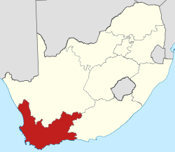
Country  South Africa
Established 27 April 1994 Capital Cape Town Districts Government – Type Parliamentary system – Premier Helen Zille (DA) Area[1] – Total 129,462 km2 (49,985.6 sq mi) Area rank 4th in South Africa Highest elevation 2,325 m (7,628 ft) Lowest elevation 0 m (0 ft) Population (2007)[2][3] – Total 5,278,585 – Estimate (2010) 5,223,900 – Rank 4th in South Africa – Density 40.8/km2 (105.6/sq mi) – Density rank 5th in South Africa Population groups[4] – Coloured 50.2% – Black African 30.1% – White 18.4% – Indian or Asian 1.3% Languages[5] – Afrikaans 55.3% – Xhosa 23.7% – English 19.3% Time zone SAST (UTC+2) ISO 3166 code ZA-WC GDP (nominal)[6] 2009 - Total R 264.98 billion
US$ 33.88 billion- Per capita R 50,726
US$ 6,488- Growth  -1.45%
Website www.westerncape.gov.za The Western Cape is a province in the south west of South Africa. The capital is Cape Town. Prior to 1994, the region that now forms the Western Cape was part of the much larger (and now defunct) Cape Province. Prior to the formation of the Union of South Africa in 1910, it was called the Cape Colony (see the History of Cape Colony).
Contents
Geography
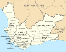
 Map of the Western Cape
The Western Cape is roughly L-shaped, extending north and east from the Cape of Good Hope, the southwestern corner of South Africa. It stretches about 400 kilometres (250 mi) northwards along the Atlantic coast and about 500 kilometres (300 mi) eastwards along the Indian Ocean coast. It is bordered on the north by the Northern Cape and on the east by the Eastern Cape. The total land area of the province is 129,462 square kilometres (49,986 sq mi),[7] about 10.6% of the country’s total. It is roughly the size of England or the US state of Louisiana.
The Breede, Berg and Olifants Rivers are major rivers of the province. The capital is Cape Town and other major cities include Stellenbosch, Worcester, Paarl, and George. The Garden Route and the Overberg are popular coastal tourism areas.
The Western Cape is exceptionally topographically diverse. Most of the province falls within the Cape Fold Belt, a range of sandstone folded mountains of Permian to Carboniferous age that range in height from 1000m to 2300m. The valleys between ranges are generally very fertile and contains alluvial loamy to clay soils.[citation needed] The far interior forms part of the Karoo Basin and is generally arid and hilly with a sharp escarpment in the north. Coastal areas range from sandy between capes, to rocky to steep and mountainous in places. The Western Cape is also the southernmost region of the African continent with Cape Agulhas as its southernmost point, only 3800 km from the Antarctic coastline.
Vegetation is also extremely diverse, with one of the world's seven floral kingdoms almost exclusively endemic to the province, namely the Cape Floral Kingdom, most of which is covered by Fynbos (Afrikaans: Fine Bush). It is extremely rich in species diversity, with more plant species occurring on Table Mountain than the entire United Kingdom. It is characterised by various types of shrubs, thousands of flowering plant species and some small trees.
The arid interior is dominated by Karoo drought-resistant shrubbery. The West Coast and Little Karoo are semi-arid regions and are typified by many species of succulents and drought-resistant shrubs and acacia trees. The Garden Route is extremely lush, with temperate rainforest (or Afromontane Forest) covering many areas adjacent to the coast and along the mountain ranges. Typical species are hardwoods of exceptional height, such as Yellowwood, Stinkwood and Ironwood trees.
Climate
The Western Cape is also diverse climatologically, with many distinct micro- and macroclimates created by the varied topography and the influence of both the Indian (warm water) and Atlantic (cold water) oceans, thus climatic statistics can vary greatly over short distances. Most of the province is considered to have a Mediterranean climate with cool, wet winters and warm, dry summers. The interior Karoo has a semi-arid climate with cold, frosty winters and hot summers with occasional thunderstorms. The Garden Route and the Overberg on the south coast have a maritime climate with cool, moist winters and mild, moist summers. Mossel Bay in the Garden Route is considered to have the second mildest climate worldwide after Hawaii.
Thunderstorms are generally rare in the province, except in the Karoo interior, with most precipitation being of a frontal or orographic nature. Extremes of heat and cold are common inland, but rare near the coast. Snow is a common winter occurrence on the higher lying ground, however frost is relatively rare in coastal areas and many of the heavily cultivated valleys.
The dependency of the Prince Edward Islands are subantarctic islands, which experience year-round cool to cold temperatures with high precipitation and little annual deviation on both accounts.
- Cape Town International Airport averages: January maximum: 26 °C (min: 16 °C), July maximum: 18 °C (min: 7 °C), annual rainfall: 515mm
- Kirstenbosch, Cape Town annual rainfall: 1395mm
- George averages: January maximum: 25 °C (min: 15 °C), July maximum: 19 °C (min: 7 °C), annual rainfall: 715mm
- Marion Island (Prince Edward Group) averages: January maximum: 10 °C (min: 5 °C), July maximum: 6 °C (min: 1 °C), annual rainfall: 2401mm
Cities and towns
The population figures quoted only include urbanised areas:
Population 1,000,000++
Population 200,000+
- George
- Somerset West
Population 50,000+
- Paarl
- Stellenbosch
- Strand
Population 10,000+
- Bredasdorp
- Ceres
- Hermanus
Population < 10,000
History since 1994
In 1994, after the inauguration of South Africa's first black president, Nelson Mandela, the Cape Province was broken up into three provinces: Western Cape, Northern Cape and Eastern Cape (which encompasses the former Xhosa homelands of Transkei and Ciskei). However, the Western Cape set itself apart early in post-apartheid South African history by being one of the two provinces to have rejected an ANC mandate (the other being KwaZulu-Natal) by electing former South African Law and Order minister Hernus Kriel (NP) as the first premier of the Western Cape. It would be dominated by the National Party, and its successor, until the party's announced 2004 merger with the ANC, which brought ex-premier Ebrahim Rasool to power.
Law and government
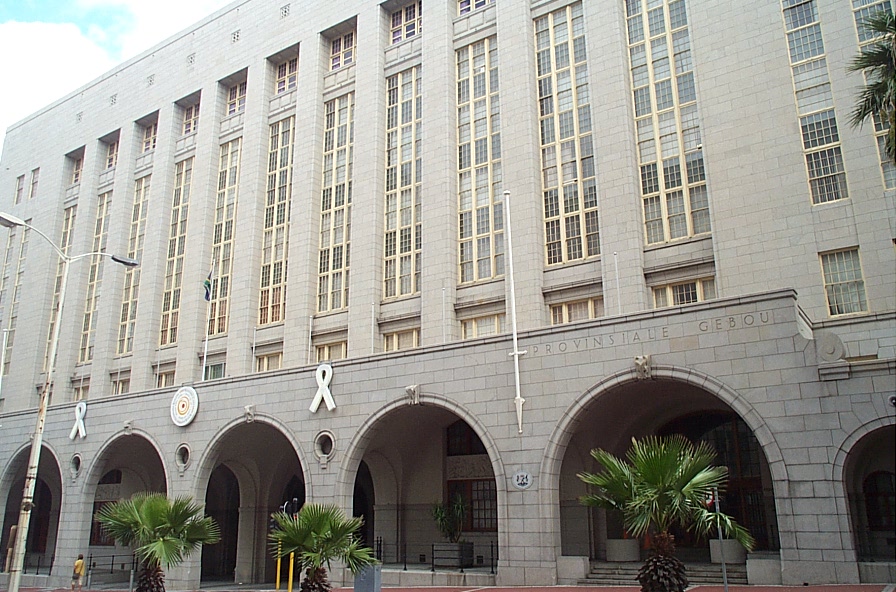
Main articles: Government of the Western Cape and Politics of the Western Cape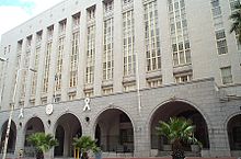 Western Cape provincial building, Cape Town.
The capital of the Western Cape is the City of Cape Town. The Premier of the Western Cape is Helen Zille[8] while the Director-General of the provincial administration is Virginia Petersen.[9]
The Constitution of the Western Cape was adopted in 1998 and is published in the official languages of the province: Afrikaans, English and Xhosa.
The Western Cape Provincial Parliament is responsible for creating laws within its responsibilities as set out by the South African Constitution. Some of the issues dealt with cover agriculture, education, environment, health services, housing, language policies, tourism, trade, and welfare. It is housed in Cape Town and has a total of 42 members. The Fourth Provincial Parliament was elected in the election of 22 April 2009; 22 seats are held by the Democratic Alliance, 14 by the African National Congress, 3 by the Congress of the People, 2 by the Independent Democrats, and 1 by the African Christian Democratic Party.
Municipalities
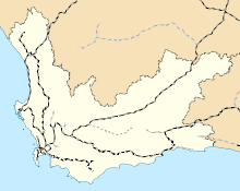
 Map of the municipalities of the Western Cape
The Western Cape is made up of one metropolitan municipality, and five district municipalities subdivided into 24 local municipalities.
- City of Cape Town
Economy
Main article: Economy of the Western CapeThe Western Cape's total GDP for 2008 was R268.26bn, making the province the third-highest contributor to the country’s total GDP, at 14.3%. In 2008 the province had the second fastest growing economy in the country growing at 4%, just behind Gauteng provice which grew at 4.1% in the same year.[10] Close to 30% of the gross regional product comes from foreign trade.[11] The province has a substantially lower unemployment rate than the national average (25%); 15% of the working population is unemployed.
The biggest sector in the Western Cape's economy is the financial, business services and realestate sectors contributing approximately R77 billion in 2008. Manufacturing was the second largest contributor valued at R43.7 billion in 2008 with the agricultural sector being th fastest growing at 10.6% in the same year.[10] High-tech industries, international call centres, fashion design, advertising and TV production are niche industries rapidly gaining in importance.[12] The city of Cape Town is ranked as the most entrepreneurial city in South Africa with Early-Stage Entrepreneurial Activity being 190% greater than South Africa’s national average.[13]
Infrastructure and communications
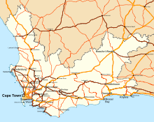
 Railway network in the Western Cape
The Western Cape has an excellent network of highways comparable with any first-world country. The primary highways are the N1 (from Cape Town to Three Sisters, continuing outside the province towards Bloemfontein and Johannesburg), N2 (from Cape Town to Bloukrans River, towards Port Elizabeth), N7 (from Cape Town to Bitterfontein, continuing towards Springbok and Namibia) and N12 (from George to Three Sisters, continuing towards Kimberley and Johannesburg). Other routes are the "R" roads which connect the smaller towns. All major roads are tarred with major rural gravel roads well maintained. Limited access motorways are limited to the Cape Metropolitan Area, Winelands and Garden Route, however due to the low population density of the remainder of the province, the highways remain efficient and high-speed, except during peak holiday travel seasons, when travel can be slow-going in places due to heavy traffic.[citation needed]
Telecommunications in the province are highly sophisticated. Landline telephones are available extensively, and the majority of large urban nodes have access to ADSL and other high-speed internet services.[citation needed] Mobile cellular networks are world-class, with reception extending from cities to highways and many remote rural areas.[citation needed] Mobile networks also play an important role in the internet space due to their speed and widespread availability. Major cities and towns have access to mobile internet speeds in excess of 21 Mbit/s (HSDPA+). In areas where HSDPA+ is not available, networks make provisions for HSDPA, 3G, EDGE or finally GPRS if demand does not warrant higher speed investment.[citation needed]
Demographics
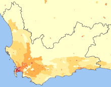 Population density in the Western Cape<1 /km²1–3 /km²3–10 /km²10–30 /km²30–100 /km²100–300 /km²300–1000 /km²1000–3000 /km²>3000 /km²
As of the census of 2001,[14] there were 4,524,336 people in the Western Cape, living in 1,173,302 households. The population density was 34.97/km² and the household density 9.07/km². In terms of race, 53.91% of people described themselves as Coloured, 26.68% as Black, 18.41% as White, and 1.00% as Indian or Asian 1.00%.
Age distribution in the province is spread out, with 27.3% under the age of 15, 19.4% from 15 to 24, 32.9% from 25 to 44, 15.2% from 45 to 64, and 5.2% who are 65 years of age or older. The median age is 26 years. For every 100 females there are 94.0 males. For every 100 females age 18 and over, there are 91.3 males.
In the province 55.3% of residents speak Afrikaans at home, 23.7% speak Xhosa, 19.3% speak English, and less than 2% speak another language.
81.8% of residents are Christian, 9.0% have no religion, 6.5% are Muslim, 0.4% are Jewish, and 0.2% are Hindu. 2.1% have other or undetermined beliefs.
5.7% of residents aged 20 and over have received no schooling, 15.2% have had some primary, 7.9% have completed only primary school, 36.5% have had some high education, 23.4% have finished only high school, and 11.2% have an education higher than the high school level. Overall, 34.6% of residents have completed high school.
63.1% of housing units have a telephone and/or cell-phone in the dwelling, 34.2% have access to a phone nearby, and 2.7% have access that is not nearby or no access. 86.5% of households have a flush or chemical toilet. 87.8% have refuse removed by the municipality at least once a week and 1.4% have no rubbish disposal. 67.5% have running water inside their dwelling, 85.2% have running water on their property, and 98.3% have access to running water. 78.8% of households use electricity for cooking, 73.4% for heating, and 88.0% for lighting. 79.1% of households have a radio, 74.1% have a television, 18.2% own a computer, 73.5% have a refrigerator, and 41.4% have a cell-phone.
17.1% of the population aged 15–65 is unemployed. Of the unemployed persons, 53.4% are Black, 43.0% are Coloured, 0.4% are Indian/Asian, and 3.2% are White. 23.3% of Black are unemployed, 9.3% of Coloureds, 5.0% of Indians/Asians, and 2.0% of Whites.
The median annual income of working adults aged 15–65 in the Western Cape is R 18,703. Males have a median annual income of R 21,048 versus R 17,035 for females. The median annual income by race is R 12,213 for Blacks, R 16,354 for Coloureds, R 42,803 for Indians/Asians, and R 64,968 for Whites.
Distribution of annual income[15] Category No income 2.0% R 12 – R 4 800 ($2 – $721) 6.5% R 4 812 – R 9 600 ($723 – $1,443) 17.7% R 9 612 – R 19 200 ($1,445 – $2,886) 25.1% R 19 212 – R 38 400 ($2,888 – $5,772) 20.1% R 38 412 – R 76 800 ($5,774 – $11,543) 15.2% R 76 812 – R 153 600 ($11,545 – $23,087) 8.3% R 153 612 – R 307 200 ($23,089 – $46,174) 3.3% R 307 212 – R 614 400 ($46,176 – $92,348) 1.1% R 614 412 or more ($92,350+) 0.7% Education
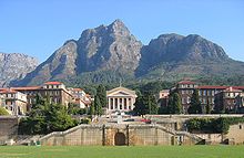 The University of Cape Town
The Western Cape is the most highly educated province with a very skilled workforce in comparison to any other African region.[16] The high school graduation rate is consistently around 80%, higher than any other province. The proportion of adults with a degree or higher was 4.8% (2005),[12] the highest in the country.
The province also boasts three internationally acclaimed universities, namely the University of Cape Town, Stellenbosch University and the University of the Western Cape.
- Universities
- Other Educational Institutions
References
- ^ Stats in Brief, 2010. Pretoria: Statistics South Africa. 2010. p. 3. ISBN 978-0-621-39563-1. http://www.statssa.gov.za/publications/StatsInBrief/StatsInBrief2010.pdf.
- ^ "Community Survey 2007: Basic results" (PDF). Statistics South Africa. p. 2. http://www.statssa.gov.za/publications/CS2007Basic/CS2007Basic.pdf. Retrieved 14 January 2011.
- ^ Mid-year population estimates, 2010 (Report). Statistics South Africa. 2010. http://www.statssa.gov.za/publications/P0302/P03022010.pdf. Retrieved 14 January 2011.
- ^ "Statistical release P0301: Community Survey, 2007 (Revised version)" (PDF). Statistics South Africa. p. 25. http://www.statssa.gov.za/publications/P0301/P0301.pdf. Retrieved 7 October 2009.
- ^ "Table: Census 2001 by province, language, population group and gender.". Census 2001 Interactive Tables. Statistics South Africa. http://www.statssa.gov.za/timeseriesdata/pxweb2006/Dialog/varval.asp?ma=Language%20by%20province&ti=Table%3A+Census+2001+by+province%2C+language%2C+population+group+and++gender%2E&path=../Database/South%20Africa/Population%20Census/Census%202001%20-%20NEW%20Demarcation%20boundaries%20as%20at%209%20December%202005/Provincial%20level%20-%20Persons/&lang=1. Retrieved 28 January 2010.
- ^ Wesgro IQ. GDP and GDP growth by Province. Wesgro.
- ^ Stats in brief, 2009. Pretoria: Statistics South Africa. 2009. p. 3. ISBN 978-0-621-38774-2. http://www.statssa.gov.za/publications/StatsInBrief/StatsInBrief2009.pdf. Retrieved 14 January 2011.
- ^ "Applause as Zille secures premiership". IOL. 6 May 2009. http://www.iol.co.za/index.php?art_id=nw20090506124045976C370668. Retrieved 6 May 2009.
- ^ "Ms Virginia Petersen". Cape Gateway. Provincial Government of the Western Cape. http://www.capegateway.gov.za/eng/gov_employees/7410. Retrieved 29 December 2008.[dead link]
- ^ a b "Western Cape Economic Overview". Westgro. http://www.wesgro.co.za/internationalbuyers/index.php?readnews+1967. Retrieved 14 May 2011.
- ^ "Investing in the Western Cape". Brand South Africa. http://www.southafrica.info/business/investing/opportunities/wcape.htm. Retrieved 29 January 2011.
- ^ a b "Fast Facts: April–May 2007, Provincial Profile, Western Cape". South African Institute of Race Relations, pg 20.
- ^ "Cape Town outshines rest of SA in entrepreneurship". University of Cape Town. http://www.gsb.uct.ac.za/newsletter/v2/Story.asp?intArticleID=278. Retrieved 26 February 2011.
- ^ "Census 2001". Statistics South Africa. http://www.statssa.gov.za/census01/html/default.asp.
- ^ Statistics South Africa Census 2001
- ^ "Skilled Workforce reference". South African Department of Sport And Recreation. http://www.za-ydf.org/displaysection.php?czacc=&zSelectedSectionID=sec1246950242.
External links
- Provincial Government of the Western Cape
- Western Cape Tourism
- Western Cape Investment and Trade Promotion Agency
Province of the Western Cape Topics Climate · Ecology · Economy · Government · Politics
Government Premier · Provincial Parliament · High Court · MunicipalitiesRegions Cape Peninsula · Cape Flats · Boland · Swartland · West Coast · Breede River Valley · Overberg · Garden Route · Little Karoo · Great KarooCities and major towns Cape Town · Paarl · George · Worcester · Somerset West · Atlantis · Strand · Stellenbosch · Oudtshoorn · Wellington · Knysna · Mossel Bay · Vredenburg · Beaufort West · Saldanha · Grabouw · Malmesbury · Robertson · Vredendal · Swellendam · Bredasdorp · Riversdale · Ashton · Caledon · Hermanus · Montagu · Ceres · Piketberg · Plettenberg Bay Administrative divisions of South AfricaProvinces Eastern Cape • Free State • Gauteng • KwaZulu-Natal • Limpopo • Mpumalanga • North West • Northern Cape • Western Cape
Municipalities Buffalo City (East London) · Cape Town · Ekurhuleni (East Rand) · eThekwini (Durban) · Johannesburg · Mangaung (Bloemfontein) · Nelson Mandela Bay (Port Elizabeth) · Tshwane (Pretoria)of the Eastern Cape · of the Free State · of Gauteng · of KwaZulu-Natal · of Limpopo · of Mpumalanga · of the North West · of the Northern Cape · of the Western Cape · Full listSettlements in the Eastern Cape · in the Free State · in Gauteng · in KwaZulu-Natal · in Limpopo · in Mpumalanga · in the North West · in the Northern Cape · in the Western CapeCategories:- Provinces of South Africa
- Western Cape
- States and territories established in 1994
- Cape Town International Airport averages: January maximum: 26 °C (min: 16 °C), July maximum: 18 °C (min: 7 °C), annual rainfall: 515mm


Wikimedia Foundation. 2010.