Districts of South Africa
- Districts of South Africa
-
South Africa is divided into 52 districts (Metropolitan and District municipalities). The 12th amendment to the Constitution (December 2005) reduced this number from 53. Another effect of this amendment is that each district is now completely contained within a province, thus eliminating cross-border districts. The districts also cover the entire area of the continental republic. South Africa's districts are analogous to counties in Great Britain and the United States.
Types of district
There are two types of municipality at the district level. Most of the country is covered by the 44 district municipalities, which are divided into local municipalities and share responsibilities with them. The eight largest urban agglomerations are governed by metropolitan municipalities, which act as both local and district municipalities.
List
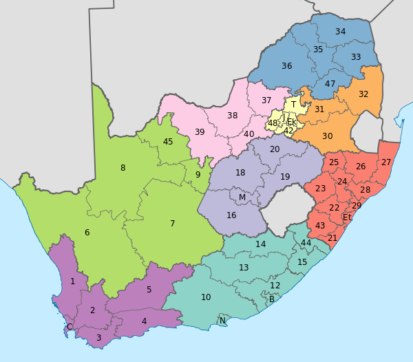
The following map depicts the provinces and districts of South Africa. The district municipalities are labelled with numbers that correspond to their district code, while the metropolitan municipalities are labelled with letters that correspond to their names. Further details of the districts are listed in the table that follows the image.

| Name |
Code |
Province |
Seat |
Area (km²) |
Population (2007) |
Pop. density (per km²) |
| Alfred Nzo District Municipality |
44 !DC44 |
Eastern Cape |
Mount Ayliff |
6,859 |
479,390 |
69.9 |
| Amajuba District Municipality |
25 !DC25 |
KwaZulu-Natal |
Newcastle |
6,911 |
442,266 |
64.0 |
| Amathole District Municipality |
12 !DC12 |
Eastern Cape |
East London |
21,043 |
940,441 |
44.7 |
| Bojanala Platinum District Municipality |
37 !DC37 |
North West |
Rustenburg |
18,333 |
1,268,618 |
69.2 |
| Buffalo City Metropolitan Municipality |
BUF |
Eastern Cape |
East London |
2,536 |
724,312 |
285.6 |
| Cacadu District Municipality |
10 !DC10 |
Eastern Cape |
Port Elizabeth |
58,194 |
363,496 |
6.2 |
| Cape Winelands District Municipality |
02 !DC2 |
Western Cape |
Worcester |
22,309 |
712,413 |
31.9 |
| Capricorn District Municipality |
35 !DC35 |
Limpopo |
Polokwane |
16,988 |
1,243,167 |
73.2 |
| Central Karoo District Municipality |
05 !DC5 |
Western Cape |
Beaufort West |
38,854 |
56,230 |
1.4 |
| Chris Hani District Municipality |
13 !DC13 |
Eastern Cape |
Queenstown |
36,695 |
798,597 |
21.8 |
| City of Cape Town Metropolitan Municipality |
CPT |
Western Cape |
Cape Town |
2,460 |
3,497,097 |
1,421.6 |
| City of Johannesburg Metropolitan Municipality |
JHB |
Gauteng |
Johannesburg |
1,645 |
3,888,180 |
2,363.6 |
| City of Tshwane Metropolitan Municipality |
TSH |
Gauteng |
Pretoria |
6,345 |
2,499,447 |
393.9 |
| Dr Kenneth Kaunda District Municipality |
40 !DC40 |
North West |
Klerksdorp |
14,642 |
634,127 |
43.3 |
| Dr Ruth Segomotsi Mompati District Municipality |
39 !DC39 |
North West |
Vryburg |
44,017 |
354,554 |
8.1 |
| Eden District Municipality |
04 !DC4 |
Western Cape |
George |
23,331 |
513,307 |
22.0 |
| Ehlanzeni District Municipality |
32 !DC32 |
Mpumalanga |
Nelspruit |
27,896 |
1,526,236 |
54.7 |
| Ekurhuleni Metropolitan Municipality |
EKU |
Gauteng |
Germiston |
1,924 |
2,724,229 |
1,415.9 |
| eThekwini Metropolitan Municipality |
ETH |
KwaZulu-Natal |
Durban |
2,292 |
3,468,086 |
1,513.1 |
| Fezile Dabi District Municipality |
20 !DC20 |
Free State |
Sasolburg |
21,301 |
474,089 |
22.3 |
| Frances Baard District Municipality |
09 !DC9 |
Northern Cape |
Kimberley |
13,518 |
353,200 |
26.1 |
| Gert Sibande District Municipality |
30 !DC30 |
Mpumalanga |
Secunda |
31,841 |
890,699 |
28.0 |
| iLembe District Municipality |
29 !DC29 |
KwaZulu-Natal |
KwaDukuza |
3,269 |
528,198 |
161.6 |
| John Taolo Gaetsewe District Municipality |
45 !DC45 |
Northern Cape |
Kuruman |
27,283 |
173,454 |
6.4 |
| Lejweleputswa District Municipality |
18 !DC18 |
Free State |
Welkom |
31,930 |
639,651 |
20.0 |
| Mangaung Metropolitan Municipality |
MAN |
Free State |
Bloemfontein |
6,284 |
752,906 |
119.8 |
| Mopani District Municipality |
33 !DC33 |
Limpopo |
Giyani |
24,489 |
1,068,568 |
43.6 |
| Namakwa District Municipality |
06 !DC6 |
Northern Cape |
Springbok |
126,836 |
126,494 |
1.0 |
| Nelson Mandela Bay Metropolitan Municipality |
NMA |
Eastern Cape |
Port Elizabeth |
1,959 |
1,050,930 |
536.5 |
| Ngaka Modiri Molema District Municipality |
38 !DC38 |
North West |
Mafikeng |
27,889 |
798,783 |
28.6 |
| Nkangala District Municipality |
31 !DC31 |
Mpumalanga |
Middelburg |
16,758 |
1,226,500 |
73.2 |
| OR Tambo District Municipality |
15 !DC15 |
Eastern Cape |
Mthatha |
15,968 |
1,862,218 |
116.6 |
| Overberg District Municipality |
03 !DC3 |
Western Cape |
Bredasdorp |
11,405 |
212,787 |
18.7 |
| Pixley ka Seme District Municipality |
07 !DC7 |
Northern Cape |
De Aar |
102,727 |
166,849 |
1.6 |
| Sedibeng District Municipality |
42 !DC42 |
Gauteng |
Vereeniging |
4,177 |
800,819 |
191.7 |
| Sekhukhune District Municipality |
47 !DC47 |
Limpopo |
Groblersdal |
13,426 |
1,090,424 |
81.2 |
| Sisonke District Municipality |
43 !DC43 |
KwaZulu-Natal |
Ixopo |
11,127 |
500,082 |
44.9 |
| Siyanda District Municipality |
08 !DC8 |
Northern Cape |
Upington |
102,524 |
238,063 |
2.3 |
| Thabo Mofutsanyana District Municipality |
19 !DC19 |
Free State |
Phuthaditjhaba |
32,637 |
753,344 |
23.1 |
| Ugu District Municipality |
21 !DC21 |
KwaZulu-Natal |
Port Shepstone |
5,047 |
709,918 |
140.7 |
| Ukhahlamba District Municipality |
14 !DC14 |
Eastern Cape |
Barkly East |
25,663 |
308,365 |
12.0 |
| uMgungundlovu District Municipality |
22 !DC22 |
KwaZulu-Natal |
Pietermaritzburg |
8,934 |
988,837 |
110.7 |
| uMkhanyakude District Municipality |
27 !DC27 |
KwaZulu-Natal |
Mkuze |
12,821 |
614,046 |
47.9 |
| uMzinyathi District Municipality |
24 !DC24 |
KwaZulu-Natal |
Dundee |
8,589 |
495,737 |
57.7 |
| uThukela District Municipality |
23 !DC23 |
KwaZulu-Natal |
Ladysmith |
11,326 |
714,908 |
63.1 |
| uThungulu District Municipality |
28 !DC28 |
KwaZulu-Natal |
Richards Bay |
8,213 |
894,260 |
108.9 |
| Vhembe District Municipality |
34 !DC34 |
Limpopo |
Thohoyandou |
21,349 |
1,240,035 |
58.1 |
| Waterberg District Municipality |
36 !DC36 |
Limpopo |
Modimolle |
49,504 |
596,092 |
12.0 |
| West Coast District Municipality |
01 !DC1 |
Western Cape |
Moorreesburg |
31,104 |
286,751 |
9.2 |
| West Rand District Municipality |
48 !DC48 |
Gauteng |
Randfontein |
4,087 |
754,903 |
184.7 |
| Xhariep District Municipality |
16 !DC16 |
Free State |
Trompsburg |
37,674 |
153,069 |
4.1 |
| Zululand District Municipality |
26 !DC26 |
KwaZulu-Natal |
Ulundi |
14,799 |
902,890 |
61.0 |
Boundary alignment
Several projects are underway to align various services with the district boundaries.[1] These include:
- Magisterial districts
- Police wards
Controversy
South Africa's official opposition, the Democratic Alliance, believes that the districts add an unnecessary fourth layer of government (between provinces and municipalities) and has called for them to be eliminated.[2]
See also
References
Sources
v · d · e Administrative divisions of South Africa Administrative divisions of South Africa |
|
|
|
|
| Provinces |
|
 |
|
| Municipalities |
|
|
|
|
|
|
of the Eastern Cape · of the Free State · of Gauteng · of KwaZulu-Natal · of Limpopo · of Mpumalanga · of the North West · of the Northern Cape · of the Western Cape · Full list
|
|
|
|
|
|
|
| Settlements |
|
|
Categories:
- Districts of South Africa
- Subdivisions of South Africa
- Lists of country subdivisions
- Country subdivisions of Africa
- Second-level administrative country subdivisions
- South Africa-related lists
Wikimedia Foundation.
2010.
Look at other dictionaries:
South Western Districts of South Africa cricket team — South Western Districts are a South African first class cricket team who are based in the Western Cape city of Oudtshoorn. They form part of the Warriors franchise and are one of five South African associate teams. Their home games are played at… … Wikipedia
Municipalities of South Africa — South Africa This article is part of the series: Politics and government of South Africa … Wikipedia
District municipality (South Africa) — South Africa This article is part of the series: Politics and government of South Africa … Wikipedia
SOUTH AFRICA — SOUTH AFRICA, republic comprising nine provinces – Western Cape, Eastern Cape, Northern Cape, North West, Gauteng, Limpopo, Mpumalanga, Free State, and KwaZulu Natal. Prior to 1994, when multiracial democracy was introduced, there were four… … Encyclopedia of Judaism
Outline of South Africa — The Flag of South Africa … Wikipedia
Geography of South Africa — Country geography name = South Africa continent = Africa region = Southern Africa coordinates = coord|29|00|S|24|00|E|type:country area ranking = 25th km area = 1221037 percent land = km coastline = 2798 borders = Total land borders: 4,862 km… … Wikipedia
South Africa — Republic of, a country in S Africa; member of the Commonwealth of Nations until 1961. 42,327,458; 472,000 sq. mi. (1,222,480 sq. km). Capitals: Pretoria and Cape Town. Formerly, Union of South Africa. * * * South Africa Introduction South Africa… … Universalium
South Africa — This article is about the modern country. For other uses, see South Africa (disambiguation). Republic of South Africa … Wikipedia
South Africa under apartheid — Apartheid (meaning separateness in Afrikaans, cognate to English apart and ) was a system of legal racial segregation enforced by the National Party government of South Africa between 1948 and 1990. Apartheid had its roots in the history of… … Wikipedia
Courts of South Africa — South Africa This article is part of the series: Politics and government of South Africa … Wikipedia

 Administrative divisions of South Africa
 Lists relating to the provinces of South Africa

