- Mount Ayliff
-
Mount Ayliff Location in the Eastern Cape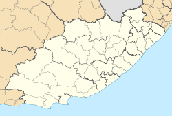
 Mount AyliffLocation in South Africa
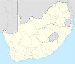 Mount Ayliff
Coordinates: 30°48′33″S 29°22′01″E / 30.80917°S 29.36694°ECoordinates: 30°48′33″S 29°22′01″E / 30.80917°S 29.36694°E Country South Africa Province Eastern Cape District municipality Alfred Nzo Local municipality Umzimvubu Population (2001)[1] - Total 4,881 Time zone SAST (UTC+2) Postal code 5090 Area code 039 Mount Ayliff is a small town in the eastern Eastern Cape province of South Africa, near that province's border with KwaZulu-Natal. In the census of 2001, its population was recorded as being 4,881 people, of whom 98% described themselves as "Black African", and 96% spoke Xhosa as their first language.[1]
Mount Ayliff is located in the Umzimvubu Local Municipality, which is part of the Alfred Nzo District Municipality; it is the location of the headquarters of the latter.[2]
References
- ^ a b "Mount Ayliff". Census 2001. http://census.adrianfrith.com/place/23816. Retrieved 30 April 2011.
- ^ "Contact information: Alfred Nzo District Municipality". Government Communication and Information System. http://www.gcis.gov.za/gcis/directory.jsp?dir=15&cat=64&org=1918. Retrieved 30 April 2011.
Province of Eastern Cape, South Africa Provincial Capital: Bhisho Metropolitan
MunicipalitiesDistrict
and Local
MunicipalitiesCamdeboo · Blue Crane Route · Ikwezi · Makana · Ndlambe · Sunday's River Valley · Baviaans · Kouga · Kou-KammaCategories:- Populated places in the Eastern Cape
- Eastern Cape geography stubs


Wikimedia Foundation. 2010.