- Chris Hani District Municipality
-
Chris Hani District Municipality — District municipality — Location in the Eastern Cape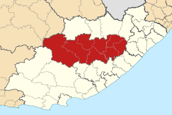
Coordinates: 31°53′S 26°52′E / 31.883°S 26.867°ECoordinates: 31°53′S 26°52′E / 31.883°S 26.867°E Country South Africa Province Eastern Cape Local municipalities List- Emalahleni
- Engcobo
- Inkwanca
- Intsika Yethu
- Inxuba
- Lukanji
- Sakhisizwe
- Tsolwana
Government - Mayor Area[1] - Total 37,294 km2 (14,399.3 sq mi) Population [1] - Total 822,291 - Density 22/km2 (57.1/sq mi) Racial makeup Languages Time zone South African Standard Time (UTC+2) Municipal code DC13 Website www.chrishanidm.gov.za Chris Hani is one of the 7 districts of Eastern Cape province of South Africa. The seat of Chris Hani is Queenstown. The majority of its 810 274 people speak Xhosa (2001 Census), although Afrikaans speaking people predominate in the far west of the district. The district code is DC13.
Contents
Geography
Neighbours
Chris Hani is surrounded by:
- Ukhahlamba (DC14) to the north
- OR Tambo (DC15) to the north-east
- Amatole (DC12) to the south
- Cacadu (DC10) to the south-west
- Pixley ka Seme (DC7) to the north-west
Local municipalities
The district contains the following local municipalities:
Local municipality Population % Intsika Yethu 194 240 23.97% Lukanji 184 539 22.77% Engcobo 148 403 18.32% Emalahleni 115 932 14.31% Inxuba Yethemba 60 295 7.44% Sakhisizwe 54 029 6.67% Tsolwana 32 515 4.01% Inkwanca 20 245 2.50% Demographics
The following statistics are from the 2001 census.
Language Population % Xhosa 755 615 93.25% Afrikaans 43 442 5.36% English 6 748 0.83% Sotho 2 013 0.25% Swati 810 0.10% Zulu 509 0.06% Ndebele 317 0.04% Other 310 0.04% Northern Sotho 197 0.02% Tswana 170 0.02% Venda 102 0.01% Tsonga 56 0.01% Gender
Gender Population % Female 435 752 53.78% Male 374 522 46.22% Ethnic group
Ethnic group Population % Black African 762 311 94.08% Coloured 31 537 3.89% White 15 923 1.97% Indian/Asian 503 0.06% Age
Age Population % 000 - 004 81 371 10.04% 005 - 009 108 992 13.45% 010 - 014 124 534 15.37% 015 - 019 110 945 13.69% 020 - 024 59 510 7.34% 025 - 029 43 980 5.43% 030 - 034 37 717 4.65% 035 - 039 37 848 4.67% 040 - 044 38 011 4.69% 045 - 049 32 186 3.97% 050 - 054 26 951 3.33% 055 - 059 21 800 2.69% 060 - 064 27 443 3.39% 065 - 069 20 117 2.48% 070 - 074 16 462 2.03% 075 - 079 9 640 1.19% 080 - 084 8 795 1.09% 085 - 089 2 328 0.29% 090 - 094 1 253 0.15% 095 - 099 301 0.04% 100 plus 90 0.01% Politics
Election results
Election results for Chris Hani in the South African general election, 2004.
- Population 18 and over: 423 583 [52.28% of total population]
- Total votes: 283 749 [35.02% of total population]
- Voting % estimate: 66.99% votes as a % of population 18 and over
Party Votes % African National Congress 234 383 82.60% United Democratic Movement 27 014 9.52% Democratic Alliance 9 676 3.41% Pan African Congress 6 227 2.19% African Christian Democratic Party 1 337 0.47% Independent Democrats 1 172 0.41% New National Party 902 0.32% Freedom Front Plus 643 0.23% SOPA 340 0.12% Azanian People's Organisation 326 0.11% United Christian Democratic Party 308 0.11% PJC 305 0.11% Inkhata Freedom Party 262 0.09% EMSA 200 0.07% NA 166 0.06% UF 130 0.05% TOP 108 0.04% CDP 90 0.03% NLP 60 0.02% KISS 55 0.02% Minority Front 45 0.02% Total 283 749 100.00% Notes
- ^ a b "Chris Hani District Municipality". South Africa Cooperative Development and Traditional Affairs. http://web.ndmc.gov.za/Profiles/Provincial_Profiles/EC_Chris_Hani.htm. Retrieved 02 December 2009.
References
- Chris Hani DM Official Website
- Municipal Demarcation Board
- Stats SA Census 2001 page
- Independent Electoral Commission 2004 election results

Intsika Yethu • Lukhanji • Engcobo • Emalahleni • Inxuba Yethemba • Sakhisizwe • Tsolwana • Inkwanca
Cities and towns Province of Eastern Cape, South Africa Provincial Capital: Bhisho Metropolitan
MunicipalitiesDistrict
and Local
MunicipalitiesCamdeboo · Blue Crane Route · Ikwezi · Makana · Ndlambe · Sunday's River Valley · Baviaans · Kouga · Kou-KammaChris HaniCategories:- District Municipalities of the Eastern Cape

Wikimedia Foundation. 2010.