- Ntabankulu Local Municipality
-
Ntabankulu — Local municipality — Location in the Eastern Cape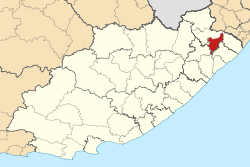
Coordinates: 32°10′S 28°35′E / 32.167°S 28.583°ECoordinates: 32°10′S 28°35′E / 32.167°S 28.583°E Country South Africa Province Eastern Cape District OR Tambo District Seat Tabankulu Area - Total 1,455 km2 (561.8 sq mi) Population (2007)[1] - Total 141,358 - Density 97.2/km2 (251.6/sq mi) - Households 27,930 Racial makeup[2] (2007) - Black African 99.93% - White 0.02% - Coloured 0.00% - Indian or Asian 0.04% Time zone SAST (UTC+2) Municipal code EC152 Ntabankulu Local Municipality is an administrative area in the OR Tambo District of Eastern Cape in South Africa.
Ntabankulu is an isiXhosa name meaning “great or big mountain”, since the municipal area is mountainous in character.[3]
It is currently part of the OR Tambo District Municipality, but after the 2011 municipal election it will be transferred to the Alfred Nzo District Municipality.[4]
References
- ^ "Community Survey, 2007: Basic Results Municipalities" (PDF). Statistics South Africa. http://www.statssa.gov.za/Publications/P03011/P030112007.pdf. Retrieved 2009-10-20.
- ^ "Community Survey 2007 interactive data". Statistics South Africa. http://www.statssa.gov.za/community_new/content.asp?link=interactivedata.asp. Retrieved 19 October 2009.
- ^ South African Languages - Place names
- ^ "MFMA Circular No. 54: Municipal Budget Circular for the 2011/12 MTREF". National Treasury. 10 December 2010. p. 5. http://mfma.treasury.gov.za/MFMA/Circulars/MFMA%20Circular%20No%2054%20-%20MFMA%20Circular%202011_12%20MTREF_FINAL.pdf. Retrieved 23 March 2011.
Province of Eastern Cape, South Africa Metropolitan
MunicipalitiesDistrict
and Local
MunicipalitiesCamdeboo · Blue Crane Route · Ikwezi · Makana · Ndlambe · Sunday's River Valley · Baviaans · Kouga · Kou-KammaCategories:- Local Municipalities of OR Tambo

Wikimedia Foundation. 2010.