- Namakwa District Municipality
-
Namakwa — District municipality — 
SealLocation of Namakwa District Municipality within Northern Cape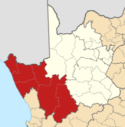
Coordinates: 29°40′S 17°53′E / 29.667°S 17.883°ECoordinates: 29°40′S 17°53′E / 29.667°S 17.883°E Country  South Africa
Province Northern Cape Seat Springbok Government - Mayor Josua Losper (ANC) Area - Total 126,747 km2 (48,937.3 sq mi) Population [1] - Total 108,118 - Density 0.9/km2 (2.2/sq mi) Racial makeup - Coloured 83.90% - White 11.80% - Black 4.18% Languages - Afrikaans 95.55% - Xhosa 1.48% - Tswana 1.12% - English 1.06% Time zone SAST (UTC+02) Municipal code DC6 Website namakwa-dm.gov.za Namakwa is one of the 5 districts of the Northern Cape province of South Africa. The seat of Namakwa is Springbok and the region is also known as Little Namaqualand. The majority of its 108 118 people speak Afrikaans (2001 Census). The district code is DC6.
Contents
Geography
Neighbours
Namakwa is surrounded by:
- the republic of Namibia in the north
- Siyanda (DC8) in the north-east
- Pixley ka Seme (DC7) in the east
- Central Karoo (DC5) in the south-east
- Cape Winelands (DC2) - in the south (formerly the Boland District Municipality)
- West Coast (DC1) in the south-west
- the Atlantic Ocean in the west
Local municipalities
The district contains the following local municipalities:
Local municipality Population % Nama Khoi 44 752 41.39% Hantam 19 804 18.32% Khâi-Ma 11 348 10.50% Kamiesberg 10 743 9.94% Karoo Hoogland 10 508 9.72% Richtersveld 10 119 9.36% Namaqualand 813 0.75% Demographics
The following statistics are from the 2001 census.
Language Population % Afrikaans 103 304 95.55% Xhosa 1 595 1.48% Tswana 1 211 1.12% English 1 143 1.06% Other 415 0.38% Sotho 219 0.20% Zulu 116 0.11% Tsonga 26 0.02% Northern Sotho 18 0.02% Venda 16 0.01% Swati 15 0.01% Ndebele 9 0.01% Gender
Gender Population % Female 54 651 50.55% Male 53 467 49.45% Ethnic group
Ethnic group Population % Coloured 90 713 83.90% White 12 757 11.80% Black African 4 523 4.18% Indian/Asian 125 0.12% Age
Age Population % 000 - 004 9 990 9.24% 005 - 009 10 690 9.89% 010 - 014 11 028 10.20% 015 - 019 9 809 9.07% 020 - 024 8 212 7.60% 025 - 029 8 367 7.74% 030 - 034 8 647 8.00% 035 - 039 8 086 7.48% 040 - 044 6 996 6.47% 045 - 049 6 387 5.91% 050 - 054 4 971 4.60% 055 - 059 4 232 3.91% 060 - 064 3 437 3.18% 065 - 069 2 671 2.47% 070 - 074 1 929 1.78% 075 - 079 1 216 1.12% 080 - 084 786 0.73% 085 - 089 453 0.42% 090 - 094 165 0.15% 095 - 099 43 0.04% 100 plus 3 0.00% Politics
Election results
Election results for Namakwa in the South African general election, 2004.
- Population 18 and over: 70 397 [65.11% of total population]
- Total votes: 44 220 [40.90% of total population]
- Voting % estimate: 62.82% votes as a % of population 18 and over
Party Votes % African National Congress 26 557 60.06% Democratic Alliance 7 104 16.07% New National Party 4 379 9.90% Independent Democrats 4 216 9.53% African Christian Democratic Party 867 1.96% Freedom Front Plus 536 1.21% Pan Africanist Congress 75 0.17% United Democratic Movement 63 0.14% United Christian Democratic Party 54 0.12% Inkhata Freedom Party 49 0.11% NA 42 0.09% EMSA 39 0.09% PJC 38 0.09% KISS 37 0.08% Azanian People's Organisation 34 0.08% CDP 28 0.06% SOPA 27 0.06% TOP 23 0.05% NLP 20 0.05% UF 18 0.04% Minority Front 14 0.03% Total 44 220 100.00% References
- Municipal Demarcation Board
- Stats SA Census 2001 page
- Independent Electoral Commission 2004 election results
External links

Hantam • Kamiesberg • Karoo Hoogland • Khâi-Ma • Nama Khoi • Richtersveld
Cities and towns Aggeneys • Alexander Bay • Brandvlei • Buffelsrivier • Bulletrap • Calvinia • Carolusberg • Concordia • Eksteenfontein • Fraserburg • Garies • Hondeklip Bay • Kamassies • Kamieskroon • Karkams • Kheis • Khubus • Kleinzee • Klipfontein • Koingnaas • Komaggas • Lekkersing • Leliefontein • Loeriesfontein • McDougall's Bay • Nababeep • Niewoudtville • Nourivier • Okiep • Onseepkans • Paulshoek • Pella • Pofadder • Port Nolloth • Rooifontein Norap • Sanddrif • Soebatsfontein • Spoegrivier • Springbok • Steinkopf • Sutherland • Tweerivier • Vioolsdrif • Williston
Province of Northern Cape, South Africa Provincial Capital: Kimberley District
and Local
MunicipalitiesNamakwaJohn Taolo GaetseweCategories:- District municipalities of the Northern Cape
- Namaqualand


Wikimedia Foundation. 2010.