- Northern Cape
-
For other uses, see North Cape (disambiguation).
Northern Cape
Noord-Kaap (Afrikaans)
Kapa Bokone(Tswana)
Mntla-Koloni (Xhosa)— Province of South Africa — The Province of the Northern Cape 
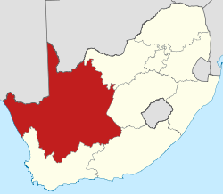
Coat of armsMotto: Sa //a !aĩsi 'uĩsi (We go to a better life) Location of the Northern Cape in South Africa Country  South Africa
Established 27 April 1994 Capital Kimberley Districts List- Namakwa
- Pixley ka Seme
- Siyanda
- Frances Baard
- John Taolo Gaetsewe
Government – Type Parliamentary system – Premier Hazel Jenkins (ANC) Area[1] – Total 372,889 km2 (143,973.2 sq mi) Area rank 1st in South Africa Highest elevation 2,156 m (7,073 ft) Lowest elevation 0 m (0 ft) Population (2007)[2][3] – Total 1,058,060 – Estimate (2010) 1,103,900 – Rank 9th in South Africa – Density 2.8/km2 (7.3/sq mi) – Density rank 9th in South Africa Population groups[4] – Coloured 50.0% – Black African 39.8% – White 10.0% – Indian or Asian 0.2% Languages[5] – Afrikaans 56.6% – Tswana 33.7% – Xhosa 5.4% – English 2.1% – Sotho 1.0% Time zone SAST (UTC+2) ISO 3166 code ZA-NC Website www.northern-cape.gov.za The Northern Cape (Afrikaans: Noord-Kaap) is the largest and most sparsely populated province of South Africa. It was created in 1994 when the Cape Province was split up. Its capital is Kimberley. It includes the Kalahari Gemsbok National Park, part of an international park shared with Botswana. It also includes the Augrabies Falls and the diamond mining regions in Kimberley and Alexander Bay. The Namaqualand region in the west is famous for its Namaqualand daisies. The southern towns of De Aar and Colesberg, in the Great Karoo, are major transport nodes between Johannesburg, Cape Town and Port Elizabeth. In the northeast, Kuruman is famous as a mission station and also for its 'eye'. The Orange River flows through the province, forming the borders with the Free State in the southeast and with Namibia to the northwest. The river is also used to irrigate the many vineyards in the arid region near Upington.
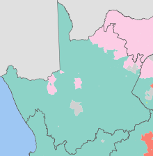
Native speakers of Afrikaans comprise a higher percentage of the population in the Northern Cape than in any other province. The Northern Cape's four official languages are Afrikaans, Tswana, Xhosa, and English. Minorities speak the other official languages of South Africa, and a few people speak Khoisan languages such as Nama and Khwe.
The provincial motto, Sa ||a !aĩsi 'uĩsi (“We go to a better life”), is in the Nǀu language of the Nǁnǂe (ǂKhomani) people. It was given in 1997 by one of the language's last speakers, Ms. Elsie Vaalbooi of Rietfontein, who has since died. It was South Africa's first officially registered motto in a Khoisan language. Subsequently, South Africa's national motto, !Ke e /xarra //ke, was derived from the extinct Northern Cape ǀXam language.
Contents
History
Main article: History of the Northern CapeThe Northern Cape was one of three provinces carved out of the Cape Province in 1994, the others being Western Cape to the south and Eastern Cape to the southeast. Politically, it had been dominated since 1994 by the African National Congress (ANC). Ethnic issues are important in the politics of the Northern Cape. For example, it is the site of the controversial Orania settlement, whose leaders have called for a Volkstaat for the Afrikaner people in the province.
The Northern Cape is also the home of over 1,000 San who immigrated from Namibia following the independence of the country; they had served as trackers and scouts for the South African government during the war, and feared reprisals from their former foes. They were awarded a settlement in Platfontein in 1999 by the Mandela government.
The precolonial history of the Northern Cape is reflected in a rich, mainly Stone Age, archaeological heritage. Cave sites include Wonderwerk Cave near Kuruman, which has a uniquely long sequence stretching from the turn of the twentieth century at the surface to more than 1 million (and possibly nearly 2 million) years in its basal layer (where stone tools, occurring in very low density, may be Oldowan).[6] Many sites across the province, mostly in open air locales or in sediments alongside rivers or pans, document Earlier, Middle and Later Stone Age habitation. From Later Stone Age times, mainly, there is a wealth of rock art sites – most of which are in the form of rock engravings such as at Wildebeest Kuil and many sites in the area known as ǀXam -ka !kau, in the Karoo. They occur on hilltops, slopes, rock outcrops and occasionally (as in the case of Driekops Eiland near Kimberley), in a river bed.[7] In the north eastern part of the province there are sites attributable to the Iron Age such as Dithakong.[8] Environmental factors have meant that the spread of Iron Age farming westwards (from the 17th century – but dating from the early first millennium AD in the eastern part of South Africa) was constrained mainly to the area east of the Langeberg Mountains, but with evidence of influence as far as the Upington area in the eighteenth century. From that period the archaeological record also reflects the development of a complex colonial frontier when precolonial social formations were considerably disrupted and there is an increasing 'fabric heavy' imprint of built structures, ash-heaps, and so on. The copper mines of Namaqualand and the diamond rush to the Kimberley area resulted in industrial archaeological landscapes in those areas which herald the modern era in South African history.
All archaeological traces in the Northern Cape that are greater than 100 years old are automatically protected by the South African Heritage Resources Act, while some are formally protected by declaration as either Provincial Heritage Sites (e.g. Wildebeest Kuil and Nooitgedacht) or National Heritage Sites (e.g. Wonderwerk Cave). The archaeology of the Richtersveld is part of the universal cultural value recognised in the area’s listing as a World Heritage Site, while sites included on South Africa's Tentative List for World Heritage inscription include Wonderwerk Cave and the ǀXam and ǂKhomani heartland.
Geography
 A waterfall situated a few miles north of Nieuwoudtville on the road to Loeriesfontein, in the Northern Cape (Namaqualand region).
The Northern Cape is South Africa's largest province, and distances between towns are enormous due to its sparse population. Its size is just shy of the size of the American state of Montana and slightly larger than that of Germany. The province is dominated by the Karoo Basin and consists mostly of sedimentary rocks and some Dolerite intrusions. The south and south-east of the province is high-lying (1200m-1900m) in the Roggeveld and Nuweveld districts. The west coast is dominated by the Namaqualand region, famous for its spring flowers. This area is hilly to mountainous and consists of Granites and other metamorphic rocks. The central areas are generally flat with interspersed salt pans. Kimberlite intrusions punctuate the Karoo rocks, giving the province its most precious natural resource, Diamonds. The north is primarily Kalahari Desert, characterised by parallel red sand dunes and acacia tree dry savanna.
Northern Cape has a shoreline in the west on the South Atlantic Ocean. It borders the following areas of Namibia and Botswana:
- Karas Region, Namibia – northwest
- Hardap Region, Namibia – far northwest
- Kgalagadi District, Botswana – north
Domestically, it borders the following provinces:
- North West – northeast
- Free State – east
- Eastern Cape – southeast
- Western Cape – south and southwest
Rivers
The major river system is the Orange (or Gariep) River Basin, draining the interior of South Africa westwards into the Atlantic Ocean. (The political philosopher Neville Alexander has used the idea of the ‘Garieb’ as a metaphor for nationhood in South Africa, a flowing together, in preference to the rainbow metaphor where the diverse colours remain distinct.)[9] The principal tributary of the Orange is the Vaal River, which flows through part of the Northern Cape from the vicinity of Warrenton. The Vaal, in turn, has tributaries within the province: the Harts River and the Riet River, which has its own major tributary, the Modder River. Above the Orange-Vaal confluence, the Seekoei River drains part of the northeastern Karoo into the Orange River above the Van der Kloof Dam. Next downstream from the Orange-Vaal confluence is the Brak River, which flows non-perennially from the south and is in turn fed by the Ongers River, rising in the vicinities of Hanover and Richmond respectively. Along the Orange River near the town of Kakamas, the Hartebeest River drains the central Karoo. Above Kenhardt the Hartebeest is known as the Sak River, which has its source on the northern side of the escarpment, southeast of Williston. Further downstream from Kakamas, below the Augrabies Falls, and seldom actually flowing into the Orange River, is the Molopo River, which comes down from the Kalahari in the north. With its tributary, the Nossob River, it defines part of the international boundary between South Africa and Botswana. Further tributaries of the Molopo River include the Kuruman River, fed by the Moshaweng River and Kgokgole River, and the Matlhwaring River. Flowing west into the Atlantic, in Namaqualand, is the Buffels River and, further south, the Groen River.
Mountains
- Langeberg
- Korannaberg
- Skurweberge
- Kuruman Hills and Asbestos Mountains
- Ghaap Plateau
- Jan Swart se Berge
- Kareeberge
- Kamiesberge
- Richtersveld mountains
- Hantamberge
Climate
Mostly arid to semi-arid, few areas in the province receive more than 400 mm (16 in) of rainfall per annum and the average annual rainfall over the province is 202 mm (8.0 in).[10] Rainfall generally increases from west to east from a minimum average of 20 mm (0.79 in) to a maximum of 540 mm (21 in) per year. The west experiences most rainfall in winter, while the east receives most of its moisture from late summer thunderstorms. Many areas experience extreme heat, with the hottest temperatures in South Africa measured along the Namibian border. Summers maximums are generally 30 °C (86 °F) or higher, sometimes higher than 40 °C (104 °F). Winters are usually frosty and clear, with southern areas sometimes becoming bitterly cold, such as Sutherland, which often receives snow and temperatures occasionally drop below the −10 °C (14 °F) mark.
- Kimberley averages: January maximum: 33 °C (min: 18 °C), June maximum: 18 °C (min: 3 °C), annual precipitation: 414 mm (16.3 in)
- Springbok averages: January maximum: 30 °C (min: 15 °C), July maximum: 17 °C (min: 7 °C), annual precipitation: 195 mm (7.7 in)
- Sutherland averages: January maximum: 27 °C (min: 9 °C), July maximum: 13 °C (min: -3 °C), annual precipitation: 237 mm (9.3 in)
Municipalities
The Northern Cape Province is divided into five district municipalities, which are subdivided into 27 local municipalities.
- Namakwa District
- Richtersveld
- Nama Khoi
- Kamiesberg
- Hantam
- Karoo Hoogland
- Khâi-Ma
- Pixley ka Seme District
- Ubuntu
- Umsobomvu
- Emthanjeni
- Kareeberg
- Renosterberg
- Thembelihle
- Siyathemba
- Siyancuma
- Siyanda District
- Mier
- Kai !Garib
- [Hais Local Municipality|//Khara Hais]
- !Kheis
- Tsantsabane
- Kgatelopele
- Frances Baard District
- Sol Plaatje
- Dikgatlong
- Magareng
- Phokwane
- John Taolo Gaetsewe District
- Moshaweng
- Ga-Segonyana
- Gamagara
Cities and towns
Population 50,000+
Population 10,000+
- Barkly West
- Colesberg
- De Aar
- Jan Kempdorp
- Kathu
- Kuruman
- Postmasburg
- Prieska
- Springbok
- Victoria West
- Warrenton
Population < 10,000
- Carnarvon
- Garies
- Griekwastad
- Groblershoop
- Hartswater
- Keimoes
- Pofadder
- Port Nolloth
- Strydenburg
- Sutherland
- Vanderkloof
Economy
Most famous for the diamond mines around Kimberley, the Northern Cape also has a substantial agricultural area around the Orange River, including most of South Africa's sultana vineyards. Some Wine of Origin areas have been demarcated. The Orange River also attracts visitors who enjoy rafting tours around Vioolsdrif. Extensive sheep raising is the basis of the economy in the southern Karoo areas of the province.
Demographics
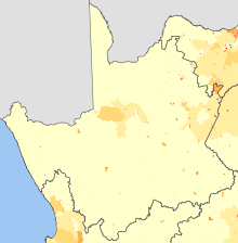
About 68% of the population speak Afrikaans, with other languages being Setswana, Xhosa and English. Since 2001, the majority of the Northern Cape population has been Coloured.[11]
Some San people still follow their traditional hunter-gatherer lifestyle in the Kalahari area of the Northern Cape. The area, especially along the Orange and Vaal rivers, is rich in San rock engravings. A good collection can be seen at the McGregor Museum in Kimberley. The province is also rich in fossils.
See also
- Griqualand West
- List of Speakers of the Northern Cape Provincial Legislature
References
- ^ Stats in Brief, 2010. Pretoria: Statistics South Africa. 2010. p. 3. ISBN 978-0-621-39563-1. http://www.statssa.gov.za/publications/StatsInBrief/StatsInBrief2010.pdf.
- ^ "Community Survey 2007: Basic results" (PDF). Statistics South Africa. p. 2. http://www.statssa.gov.za/publications/CS2007Basic/CS2007Basic.pdf. Retrieved 14 January 2011.
- ^ Mid-year population estimates, 2010 (Report). Statistics South Africa. 2010. http://www.statssa.gov.za/publications/P0302/P03022010.pdf. Retrieved 14 January 2011.
- ^ "Statistical release P0301: Community Survey, 2007 (Revised version)" (PDF). Statistics South Africa. p. 25. http://www.statssa.gov.za/publications/P0301/P0301.pdf. Retrieved 7 October 2009.
- ^ "Table: Census 2001 by province, language, population group and gender.". Census 2001 Interactive Tables. Statistics South Africa. http://www.statssa.gov.za/timeseriesdata/pxweb2006/Dialog/varval.asp?ma=Language%20by%20province&ti=Table%3A+Census+2001+by+province%2C+language%2C+population+group+and++gender%2E&path=../Database/South%20Africa/Population%20Census/Census%202001%20-%20NEW%20Demarcation%20boundaries%20as%20at%209%20December%202005/Provincial%20level%20-%20Persons/&lang=1. Retrieved 28 January 2010.
- ^ Beaumont, P.B., & Vogel, J.C. 2006. On a timescale for the past million years of human history in central South Africa. South African Journal of Science 102:217–228; Chazan, M., Ron, H., Matmon, A., Porat, N., Goldberg, P., Yates, R., Avery, M., Sumner, A., & Horwitz, L.K. 2008. Radiometric dating of the Earlier Stone Age sequence in Excavation I at Wonderwerk Cave, South Africa: preliminary results. Journal of Human Evolution 55:1–11.
- ^ Parkington, J. Morris, D. & Rusch, N. 2008. Karoo rock engravings. Clanwilliam: Krakadouw Trust
- ^ Morris, D. & Beaumont, P. 2004. Archaeology in the Northern Cape: some key sites. Kimberley: McGregor Museum.
- ^ Alexander, Neville. 2002. An ordinary country, pp 106–107
- ^ Dent, M.C., Lynch, S.D. & Schulze, R.E. 1989. Mapping Mean Annual and Other Rainfall Statistics over Southern Africa. Water Research Commission, Petoria. WRC Report 109/1/89.
- ^ http://www.elsenburg.com/provide/reports/backgroundp/BP2009_1_3_%20NC%20Demographics.pdf
External links
Province of Northern Cape, South Africa District
and Local
MunicipalitiesJohn Taolo Gaetsewe Administrative divisions of South Africa
Provinces Eastern Cape • Free State • Gauteng • KwaZulu-Natal • Limpopo • Mpumalanga • North West • Northern Cape • Western Cape
Municipalities Buffalo City (East London) · Cape Town · Ekurhuleni (East Rand) · eThekwini (Durban) · Johannesburg · Mangaung (Bloemfontein) · Nelson Mandela Bay (Port Elizabeth) · Tshwane (Pretoria)of the Eastern Cape · of the Free State · of Gauteng · of KwaZulu-Natal · of Limpopo · of Mpumalanga · of the North West · of the Northern Cape · of the Western Cape · Full listSettlements in the Eastern Cape · in the Free State · in Gauteng · in KwaZulu-Natal · in Limpopo · in Mpumalanga · in the North West · in the Northern Cape · in the Western CapeCategories:- Northern Cape
- Provinces of South Africa
- States and territories established in 1994
- Karoo
Wikimedia Foundation. 2010.


