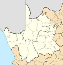
- De Aar
-
De Aar Location of De Aar Coordinates: 30°39′00″S 24°01′00″E / 30.65°S 24.0166667°ECoordinates: 30°39′00″S 24°01′00″E / 30.65°S 24.0166667°E Country South Africa Province Northern Cape District Municipality Pixley ka Seme Local Municipality Emthanjeni Established 1903 Time zone SAST (UTC+2) De Aar is a town in the Northern Cape, South Africa. It has a population of around 45,857[1] inhabitants.
It is the second-most important railway junction in the country[1], situated on the line between Cape Town and Kimberley. The junction was of particular strategic importance to the British during the Second Boer War. De Aar is also a primary commercial distribution centre for a large area of the central Great Karoo. Major production activities of the area include wool production and livestock farming. The area is also popular for hunting, despite the fact that the region is rather arid.
History
De Aar was originally established on the Farm "De Aar", the name means "the artery", a reference to its underground water supply. Because of its central location, the government selected the location for a junction on the first railway line from Cape Town to Kimberley in 1881. In 1899 two brothers who ran a trading store and hotel at the junction, Isaac and Wolf Friedlander, purchased the farm of De Aar. Following the Anglo Boer War, the Friedlander brothers surveyed the land for the establishment of a town. The municipality was created a year later and the towns first mayor, Dr Harry Baker, was elected in 1907.
Geography
Climate
De Aar has a desert climate (BWh/BWk, according to the Köppen climate classification), with warm summers (with hot days and cool nights) and cool winters. The average annual precipitation is 196 mm (8 in), with most rainfall occurring mainly during summer and autumn.
De Aar Climate chart (explanation) J F M A M J J A S O N D 2230143829144527122723811194516121601192322512258182711122913Average max. and min. temperatures in °C Precipitation totals in mm Source: SA Explorer Imperial conversion J F M A M J J A S O N D 0.986571.584571.881541.173460.466390.261340.16132066360.172410.577460.781520.58455Average max. and min. temperatures in °F Precipitation totals in inches Tourist attractions
There are ancient Khoisan rock engravings on the Nooitgedacht and Brandfontein farms. Additionally, there is a "Garden of Remembrance", which honours the British troops killed in the Anglo-Boer War. The town is also home to a major military ammunition dump. The DoD Ammunition Sub Depot De Aar is located about 2km west of the town. De Aar is famous amongst Paragliding & Hang-Gliding pilots worldwide as it holds 2 World records & many countries' National Distance records. De Aar was also the host to the XC World Series in 2008 and 2009. During the summer months De Aar is home for several thousand Kestrels. Every evening the birds fill the sky above town and land in the big trees near the hospital just as the sun sets to spend the night.
- Doornkloof Nature Reserve
- Karoo Gariep Conservancy
- Rolfontein Nature Reserve
Famous people
Olive Schreiner, the feminist author, lived in De Aar for a while, although her house has now been converted into a restaurant.
References
See also
External links
- citypopulation.de - Populations in urban areas in South Africa.
- places.co.za - De Aar
- angelfire.com - About De Aar
- De Aar environs

Strydenburg Hopetown, Orania Philipstown 
Britstown 
Colesberg  De Aar

Deelfontein Richmond Hanover Emthanjeni • Kareeberg • Renosterberg • Siyancuma • Siyathemba • Thembelihle • Ubuntu • Umsobomvu
Cities and towns Britstown • Campbell • Carnarvon • Colesberg • Copperton • De Aar • Douglas • Griquatown • Hanover • Hopetown • Loxton • Marydale • Niekerkshoop • Noupoort • Orania • Petrusville • Philipstown • Prieska • Richmond • Ritchie • Schmidtsdrift • Strydenburg • Vanwyksvlei • Vanderkloof • Victoria West • Vosburg • Westerberg
Province of Northern Cape, South Africa District
and Local
MunicipalitiesJohn Taolo GaetseweCategories:- Northern Cape geography stubs
- Populated places in the Northern Cape
- Karoo
Wikimedia Foundation. 2010.


