- Plettenberg Bay
-
Plettenberg Bay
Plettenbergbaai
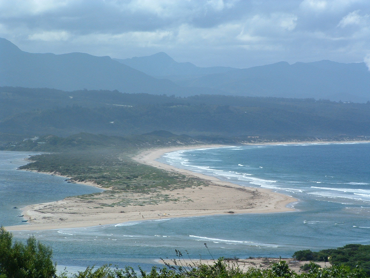
Plett— Town — The Plettenberg Bay viewed from Robberg Peninsula
 Plettenberg Bay
Coordinates: 34°03′S 23°22′E / 34.05°S 23.367°ECoordinates: 34°03′S 23°22′E / 34.05°S 23.367°E Country South Africa Province Western Cape District municipality Eden Local municipality Bitou Time zone South Africa Standard Time (UTC+2) Website http://www.plettenbergbay.co.za  Keurboom's River mouth at Plettenberg Bay viewed from the West
Plettenberg Bay, nicknamed Plet or Plett,[1] is the primary town of the Bitou Local Municipality in the Western Cape Province of South Africa. As of the census of 2001, there were 29149 population. It was originally named Bahia Formosa (beautiful bay) by early Portuguese explorers and lies on South Africa's Garden Route 210 km from Port Elizabeth and about 600 km from Cape Town.
Contents
History
Mesolithic
Caves in Nelson's Bay Cave and Matjies River Cave at nearby Keurboomstrand indicate they were inhabited for over 100 000 years by Mesolithic (Middle Stone Age) man and then later by ancestors of the Khoisan, who were possibly the same people who traded with the Portuguese survivors of the San Gonzales shipwreck. Their tools, ornaments and food debris can be viewed in these caves, which are still being excavated.
Modern
Long before Jan van Riebeeck landed at the Cape, Portuguese explorers charted the bay in the 15th and 16th centuries, the first being Bartholomew Dias in 1487. Ninety years later Manuel da Perestrello aptly called it Bahia Formosa or the Beautiful Bay. The first European inhabitants were 100 Portuguese sailors marooned here for 9 months when the San Gonzales sank in the bay in 1630.[2] The survivors built two small boats which they used to link with a passing vessel. A stone that they left behind on Beacon Island, known as the Van Plettenberg Stone, is now in the Cape Town museum. In 1763, the first European settlers in the Bay were stock farmers, hunters and frontiersmen from the Western Cape.
A stinkwood navigational beacon was first erected on Beacon Island in 1771. The original was a square block of stinkwood, inscribed with the latitude and longitude of Plettenberg Bay and erected to enable mariners to check their location. It was replaced by a stone one by Captain Sewell in 1881.
The bay housed a barracks for the Dutch East India Company in 1776. The Governor of the Cape, Baron Joachim van Plettenberg, renamed the town Plettenberg Bay in 1779. In 1869 it was bought by St Peters Church and used as a rectory for the next 70 years. Today it is presently privately owned.
In 1787/88 by Johann Jerling and the Dutch East India Company, erected a Timber Shed; the remains can still be seen and are preserved as a National Monument.
A whaling station was built on Beacon Island in 1910, but was closed down in 1916. Parts of the iron slipway are still visible today.
A hotel called The Beacon Isle Southern Sun Hotel now stands where the whaling station used to.
Ecology
Plettenberg Bay hosts one of the largest seagull breeding colonies along the South African coast at the mouth of the Keurboom's River, named after the indigenous keurboom tree.
The Robberg Peninsular is home to a large seal colony and one can see seals playing and hunting in the surf off Robberg Beach. Local vegetation varies from Cape Fynbos to indigenous forest further inland. Whales are a common sight in the bay during their breeding season, while dolphins are frequently seen in the surf. A delicate flower-shaped sea shell called a pansy shell is endemic to this part of the coast, and is used as the symbol representing the town. Looking for these shells on the beach is a popular activity amongst visitors and locals alike. Robberg Peninsula is maintained as a nature reserve, allowing visitors to see many of the area's local plants and animals.
In December 1977, the area was impacted by an oil spill from the Venpet-Venoil collision, which occurred 60 km offshore when two supertankers collided.
Plett
Shopping
A variety of shops, supermarkets, clothing, and entertainment stores cater to both locals and tourists. Plett's Main Street is home to a number of beach shops selling surf boards, swimming costumes, beach clothes, towels and other clothing. Due to the region's access to fresh fish and meat, there are a number of fish shops, butchers, and restaurants downtown.
In addition to market stands and trade shops near Plett's taxi rank, commercial developments over the past 20 years have brought luxury apartments and upscale dining to Main Street, effectively making it a high street that stands apart from the rest of the town.
Climate and geography
Plettenberg Bay is typified by an extremely mild maritime temperate climate with very few rainfall or temperature extremes. It is located within the Knysna Afromontane Forest biome, containing temperate gallery forest, supported by the mild temperatures and high, even distributed rainfall. Here follows the records for the closest climate station just to the east in the Tsitsikamma:
- Maximum/minimum temperatures: January: 23 °C/17 °C; July: 17 °C/10 °C; rainfall: 945 mm per annum.
The bay is defined on the southern end by Cape Seal at the terminus of the Robberg (Afrikaans for Seal Mountain) Peninsula, separating the bay from the open Indian Ocean. It is one of the southern cape coast's typical "J-shaped" bays, which is formed by wave action eroding the shales of the Bokkeveld Group between the weather-resistant headlands composed of the Table Mountain Group, both of the Cape Supergroup geological sequence of rocks. To the north, the Tsitsikamma and Langkloof Mountains keeps the moisture on the southern slopes of the mountains and prevent the temperature extremes of the interior reaching the bay.
Tourism
Tourism is a thriving industry in this area, starting in November when teenage school leavers are the first to descend upon the small town, followed thereafter by various waves of arrivals from abroad as well as other parts of South Africa.
The infrastructure of the town struggles to cope at the peak of the summer season, with traffic congestion and booked-out restaurants common from November to January.
The greater Plettenberg Bay area (known as Bitou) is also home to Birds of Eden, the largest free-flight bird aviary in the world, and the free-roaming primate sanctuary called Monkeyland, among many other tourist attractions.
ShowMe Plettenberg Bay is a comprehensive website and local resource covering tourism, events, entertainment, accommodation, restaurants, property, charity and business.
Beaches
The white, sandy beaches around the town are very popular with tourists, who have the following to choose from:
- Robberg Beach
- Central Beach (at the Beacon Isle Hotel)
- Lookout Beach (flood-ravaged in November 2007)
- Keurboomstrand (rough tides happen fairly frequently)
See also
References
- ^ Bekker, Leon (2007-03-09). "Integration make-over for Plet". Fin24. http://www.fin24.com/articles/default/display_article.aspx?ArticleId=1518-25_2081005. Retrieved 2008-02-26. "Not everybody in Plet is satisfied with the project, however. [...] "They feel crowded by the development and believe some parts of the Eastern Cape are still like the Plet they knew," he said."
- ^ Jacana Education (2006). Garden Route Guide. Jacana Maps. ISBN 1770091467. http://books.google.com.au/books?id=zfBEWUBvnc4C. Retrieved 2008-10-04.
External links
 External images
360° high resolution view of Plettenberg Bay taken from the rocks in front of Beacon Island Hotel - VirtualAfrica External imagesLive Webcam View of Plettenberg Bay - showMe.co.za/plett - Plettenberg Bay Tourism Centre
- Plettenberg Bay Portal
- Guest Accommodation & Activities Association Plettenberg Bay
- Crags Tourism Association
- CXPress Garden Route Newspaper

Bitou • George • Hessequa • Kannaland • Knysna • Mossel Bay • Oudtshoorn
Cities and towns Albertinia • Boggomsbaai • Brenton-on-Sea • Buffelsbaai • Calitzdorp • Dana Baai • De Rust • Dysselsdorp • Friemersheim • George • Glentana • Gouritsmond • Groot Brak Rivier • Groot-Jongensfontein • Haarlem • Hartenbos • Heidelberg • Herbertsdale • Herolds Bay • Keurboomsrivier • Keurboomstrand • Klein Brak Rivier • Knysna • Kranshoek • Kurland Estate • Ladismith • Mossel Bay • Nature's Valley • Noetzie • Oudtshoorn • Pacaltsdorp • Plettenberg Bay • Port Beaufort • Rheenendal • Riversdale • Sedgefield • Slangrivier • Stilbaai • Uniondale • Volmoed • Victoria Bay • Wilderness • Wittedrift • Zoar
Categories:- Populated places in the Eden District Municipality


Wikimedia Foundation. 2010.