- Oudtshoorn Local Municipality
-
Oudtshoorn Local Municipality — Local municipality — Location in the Western Cape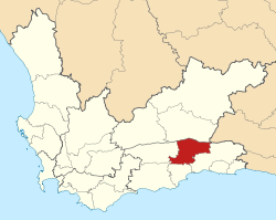
Coordinates: 33°34′S 22°11′E / 33.567°S 22.183°ECoordinates: 33°34′S 22°11′E / 33.567°S 22.183°E Country South Africa Province Western Cape District Eden Seat Oudtshoorn Government – Mayor Diane de Jager (DA) Population (2001)[1] – Total 84,692 Racial makeup Languages Time zone SAST (UTC+2) Municipal code WC045 Website http://www.oudtmun.co.za/ Oudtshoorn Municipality is a municipality located in the Western Cape Province of South Africa. As of 2001, the population was 84,692.
Towns and villages
- De Hoop
- De Rust
- Dysselsdorp
- Oudtshoorn
- Volmoed
References

Bitou • George • Hessequa • Kannaland • Knysna • Mossel Bay • Oudtshoorn
Cities and towns Albertinia • Boggomsbaai • Brenton-on-Sea • Buffelsbaai • Calitzdorp • Dana Baai • De Rust • Dysselsdorp • Friemersheim • George • Glentana • Gouritsmond • Groot Brak Rivier • Groot-Jongensfontein • Haarlem • Hartenbos • Heidelberg • Herbertsdale • Herolds Bay • Keurboomsrivier • Keurboomstrand • Klein Brak Rivier • Knysna • Kranshoek • Kurland Estate • Ladismith • Mossel Bay • Nature's Valley • Noetzie • Oudtshoorn • Pacaltsdorp • Plettenberg Bay • Port Beaufort • Rheenendal • Riversdale • Sedgefield • Slangrivier • Stilbaai • Uniondale • Volmoed • Victoria Bay • Wilderness • Wittedrift • Zoar
Metropolitan
municipality
District
and local
municipalitiesCategories:- Western Cape geography stubs
- Local Municipalities of Eden


Wikimedia Foundation. 2010.