- Molteno, Eastern Cape
-
Molteno — Town — Public library and roads in Molteno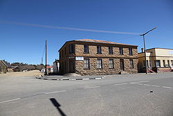
 Molteno
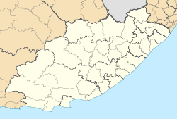
Coordinates: 31°23′46″S 26°21′47″E / 31.39611°S 26.36306°ECoordinates: 31°23′46″S 26°21′47″E / 31.39611°S 26.36306°E Country South Africa Province Eastern Cape District municipality Chris Hani Local municipality Inkwanca Time zone South Africa Standard Time (UTC+2) Molteno is a town in the Eastern Cape province of South Africa.
It was founded in 1874 and named for Sir John Molteno, the first prime minister of the Cape Colony.[1][2] High in the Stormberg Mountains, Molteno is South Africa's coldest town and it is close to the country's only ski resort. Ouma Rusks originated here.[3]
Contents
History
Coal fields were discovered in this part of the Stormberg Mountains in 1859, and the town was founded for mining in 1874 by George Vice. He named it after the first Cape Prime Minister, John Molteno.[1][2] (Interestingly, because of this, the town's other namesake is his ancestral hometown in Italy, not far from Milan.) The town's principle streets are named after the members of Molteno's cabinet. Water was drawn from the nearby Stormberg river, and later also from the Jubilee Dam.
Soon after its founding, the town became the major supplier of coal to the Cape Colony.[4] It was granted municipal status in 1883, and by 1892 around 6000 tons of coal were being extracted at Molteno.[5] However, by the 1920s the expansion of the railways made access to coal fields in Natal and the Transvaal possible, resulting in the decline of coal mining around Molteno.[6]
During the Second Boer War, Molteno was used as a mustering point for troops prior to the famous Battle of Stormberg, as it was the closest railway station.[7]
Places of interest
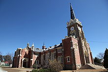 Central NK Church
Although hot and arid in summer, in winter Molteno is the coldest town in South Africa, being located near the highest point in the Cape in the heart of the Stormberg Mountains. Because of its extreme temperatures, it offers snow in the colder months and the town is not far from the country's only ski resort, Tiffindell. The town has several botanical gardens, a monument to Queen Victoria, and a historic library built from local stone.
Molteno is also home to Ouma Rusks and the Stormberg biltong factory.[3]
The Molteno Museum is located in the stone library building and aims to portray the history of the town and its surrounds. It contains a range of artifacts, from stone-age tools to Khoisan, Xhosa and Voortrekker relics including a large collection of vintage guns. It also houses local war relics from the Boer War, and a display of pioneering historical photography from the region, the "Lomax Collection".[8]
There is a lot of Bushman rock art in the surrounding mountain ranges. The area around the town offers ample opportunity to view rock paintings, fossils and stone age tools uncovered in caves and diggings close to Molteno. There are also three extinct volcanoes in the vicinity.[9]The town has one of the oldest railway stations in South Africa - now officially reopened after being closed for repairs.
Geography
Climate
Molteno has a subtropical highland climate (Cwb, according to the Köppen climate classification), with warm summers and chilly, dry winters, with occasional snowfalls. It borders on a semi-arid climate (BSh/BSk). The average annual precipitation is 401 mm (16 in), with most rainfall occurring mainly during summer.
The village of Buffelsfontein, located near Molteno, has the coldest recorded temperature in South Africa, of −18.6 °C (−1 °F), on June 28, 1996.[10]
Molteno Climate chart (explanation) J F M A M J J A S O N D 5428126426127024103620619172813061408160151943222642249472611Average max. and min. temperatures in °C Precipitation totals in mm Source: SA Explorer Imperial conversion J F M A M J J A S O N D 2.182542.579542.875501.468430.763360.355320.257320.361320.666391.372431.775481.97952Average max. and min. temperatures in °F Precipitation totals in inches Geology
Molteno is located on the Stormberg Series of the Karoo System where some of the only workable coal seams in the Cape are to be found (the Molteno Formation, within this series, is named after the town).[11] These coal fields are being explored for possible coal bed methane extraction.[12]
The rocks preserve a record of gradual desertification over millions of years, starting from the Upper Triassic when the area was a warm swampland, and continuing into the late Jurassic when the region had become a desert. Extensive Dinosaur footprints and fossils can be found in these rocks.
See also
- Eastern Cape
- Battle of Stormberg
- Stormberg Mountains
- Molteno Formation
- Sir John Molteno
References
- ^ a b Molteno, routes.co.za, Retrieved November 23, 2009
- ^ a b "History of the Wesleyan Methodist Church of South Africa". E. Stock. 1906. pp. 145. http://www.archive.org/stream/historywesleyan00whitgoog#page/n157/mode/1up. Retrieved 23 November 2009.
- ^ a b "Ouma Rusks". NOLA. http://www.nola.co.za/home.asp?pid=50. Retrieved 2008-11-09.[dead link]
- ^ Keane, A.H. (1900). The Boer states; land and people. London: Methuen & co.. pp. 6. http://www.archive.org/stream/boerstateslandpe00kean#page/n29/mode/1up. Retrieved 2009-11-24.
- ^ Noble, John (1893). "VIII - The Cape Government, Institutions, Roads, Railways and Industries". Illustrated official handbook of the Cape and South Africa; a résumé of the history, conditions, populations, productions and resources of the several colonies, states, and territories. J.C. Juta & Co.. pp. 224. http://www.archive.org/stream/illustratedoffic00nobliala#page/224/mode/1up. Retrieved 2009-11-24.
- ^ "9. The Mines". The Economic Development Of The British Overseas Empire Volume III. London: George Routledge And Sons, Limited. 1936. pp. 214. http://www.archive.org/stream/economicdevelopm031295mbp#page/n225/mode/1up. Retrieved 2009-11-24.
- ^ Foster, H.E.C. (1901). The History of the Boer War. Methuen. pp. 257. http://www.archive.org/stream/historyboerwar00cunlgoog#page/n270/mode/1up. Retrieved 2009-11-24.
- ^ Standard Encyclopaedia of South Africa. 1970. Pretoria: Nasou Ltd. Vol 7, p 497
- ^ http://www.sa-venues.com/attractionsec/molteno.php
- ^ Details of the temperature, rainfall and wind extremes recorded in SA South African weather service. Retrieved on 2010-06-22]
- ^ Gibson, Walcot (1908). "XV. Coal fields of Africa, India, Australia and South America". The geology of coal and coal-mining. London: E. Arnold. pp. 282, 283. http://www.archive.org/stream/thegeologyofcoal00gibsrich#page/282/mode/2up. Retrieved 2009-12-24.
- ^ "Background Information and Project Motivation". Badimo Gas. http://www.badimogas.co.za/operations/molteno/molteno.html. Retrieved 23 November 2009.
External links
Categories:- Populated places in the Eastern Cape


Wikimedia Foundation. 2010.