- Colony of British Columbia (1858-1866)
-
This article is about the former mainland colony. For the united colony of Vancouver Island and British Columbia, see Colony of British Columbia (1866-1871).
Colony of British Columbia British colony 1858—1866  →
→
Capital New Westminster Language(s) English Government Constitutional monarchy Queen regnant Victoria of the United Kingdom Historical era British Era - Established August 2, 1858 - Merged with Colony of Vancouver Island to form Colony of British Columbia (1866-1871) August 2, 1866 The Colony of British Columbia was a crown colony in British North America from 1858 until 1866. At its creation, it physically constituted approximately half the present day Canadian province of British Columbia, since it did not include the Colony of Vancouver Island, the vast and still largely uninhabited regions north of the Nass and Finlay Rivers, the regions east of the Rocky Mountains, or any of the coastal islands. The Colony of the Queen Charlotte Islands and the Stikine Territory were merged with it in 1863, and it was amalgamated in 1866 with the Colony of Vancouver Island to form a new Colony of British Columbia.
Contents
Background
Main Article: History of British Columbia
The explorations of James Cook and George Vancouver, and the concessions of Spain in 1794 established British claims over the coastal area north of California. Similar claims were established inland via the explorations of such men as John Finlay, Sir Alexander Mackenzie, Simon Fraser, Samuel Black, and David Thompson, and by the subsequent establishment of fur trading posts by the North West Company and the Hudson's Bay Company (HBC). However, until 1858, the region which now comprises the mainland of the Province of British Columbia was an unorganized area of British North America comprising two fur trading districts: New Caledonia, north of the Thompson River drainage; and the Columbia District, located south of the Thompson and throughout the basin of the Columbia River.
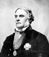 Sir James Douglas, first governor of the Colony of British Columbia
With the signing of the Treaty of Washington in 1846, which established the US border along the 49th parallel, the HBC moved the headquarters of its western operations from Fort Vancouver on the Columbia River (present day Vancouver, Washington) to the newly established Fort Victoria, on the southern tip of Vancouver Island. Vancouver Island and the surrounding Gulf Islands in the Strait of Georgia were organised as a crown colony in 1849. Meanwhile, the mainland continued to function under the de facto administration of the HBC, whose chief executive, James Douglas, also happened to be governor of Vancouver Island. The non-aboriginal mainland population during this time never exceeded about 150, mostly HBC employees and their families.
By 1857, Americans and British were beginning to respond to rumours of gold in the Thompson River area. Almost overnight, some ten to twenty thousand men moved into the region around present-day Yale, British Columbia, sparking the Fraser Canyon Gold Rush. Governor Douglas and the colonial office were suddenly faced with having to exert British authority over a largely alien population. Douglas — who had no legal authority over New Caledonia — stationed a gunboat at the entrance of the Fraser River in order to exert such authority by collecting licenses from prospectors attempting to make their way upstream. In order to normalise its jurisdiction, and undercut any HBC claims to the resource wealth of the mainland, the district was converted to a crown colony on August 2, 1858 by the Parliament of the United Kingdom, and given the name British Columbia. Douglas was offered the governorship of the new colony by the colonial secretary, Sir Edward Bulwer-Lytton, on condition that he sever his relationship with the HBC. Douglas accepted these conditions, and a knighthood. British Columbia was given its own capital — New Westminster — in 1859, but James Douglas would govern both colonies from Victoria for the next six years.
Governorship of Sir James Douglas
The influx of people into the new colony required Douglas to act quickly in drawing up regulations and creating infrastructure. Magistrates and constables were hired, mining regulations drawn up, and townsites surveyed at Yale, Hope and Fort Langley in order to discourage squatting on crown land. In addition, roads were constructed into the areas of greatest mining exploration around Lillooet and Lytton. The colony, however, was not immediately granted a representative colonial assembly, because of uncertainty as to whether the gold rush would yield a stable, settled population. Douglas, who had endured unhappy conflicts with the assembly on Vancouver Island, was relieved.

The rush indeed was short lived, and the exodus of miners, speculators, and merchants was already underway by the time the Royal Engineers had laid out the colony's new capital at New Westminster. Prospecting continued, however, and additional finds farther inland in the Cariboo region in 1860 signalled an impending second gold rush. Provisioning was already proving to be an acute problem, and with more distant finds it became clear that wagon trains would have to replace pack horses, necessitating new infrastructure. By 1862, the Cariboo Gold Rush, attracting an additional 5000 miners, was underway, and Douglas hastened construction of the Great North Road (commonly known now as the Cariboo Wagon Road) up the Fraser Canyon to the prospecting region around Barkerville.
By the time of this second gold rush, the character of the colony was changing, as a more stable population of British colonists settled in the region, establishing businesses, opening sawmills, and engaging in fishing and agriculture. With this increased stability, objections to the colony's absentee governor and the lack of responsible government began to be vocalised, led by the influential editor of the New Westminster British Columbian and future premier, John Robson. A series of petitions requesting an assembly were ignored by Douglas and the colonial office until Douglas was eased out of office in 1864. Finally the colony would have both an assembly and a resident governor.
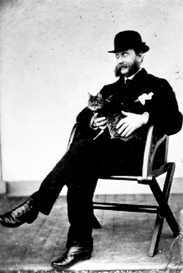
 Frederick Seymour, second governor of the Colony of British Columbia, and his cat.
Governorship of Frederick Seymour
Main article: Frederick SeymourDouglas's successor was Frederick Seymour, who came to the colony with twenty years of colonial experience in Van Diemen's Land, the British West Indies, and British Honduras. The creation of an assembly and Seymour's appointment in April, 1864 signalled a new era for the colony, now out of the shadow of Vancouver Island and free of a governor suspicious of sharing power with elected representatives. Douglas's wagon road project was still underway, presenting huge engineering challenges, as it made its way up the narrow Fraser Canyon. Successive loans authorised by Seymour's predecessor, largely for the purpose of completing the road, had put the colony £200,000 in debt; and the Chilcotin War of 1864 cost an additional £18,000 to suppress. Seymour himself made the difficult journey through the Great Canyon of the Homathko and Rainbow Range as a show of force and participation in the hunt for Klatsassin, the Tsilhqot'in war leader, but the armed expedition reached a denouement when Klatsassin surrendered on terms of amnesty in times of war, only to be tried and hanged for murder, as Seymour had not endorsed the terms.
On Seymour's return overland, he made a tour of the Cariboo minefields, and along the Fraser Canyon, which made him increasingly convinced of the colony's future prosperity. On returning to the capital, however, fiscal reality set in as it became clear that British Columbia's indebtedness was getting worse. Even as the colonial administration took drastic measures to augment revenues and improve the road system to attract prospectors and settlers, the economic situation grew increasingly dire, and agitation grew for an almagamation of the two colonies. Seymour opposed this proposal, but with pressure from various quarters of the colonial government, he eventually relented, recommending that British Columbia be the dominant partner, and (unsuccessfully) that the capital be located at New Westminster. The two colonies were united by an Act of the British Parliament, and proclaimed on August 6, 1866 (see Colony of British Columbia (1866-1871)).
Governors of British Columbia
- Sir James Douglas, 1858-1864
- Frederick Seymour, 1864-1866
See also
- Former colonies and territories in Canada
- Territorial evolution of Canada after 1867
External links
- Biography of Douglas at the Dictionary of Canadian Biography Online
- Biography of Seymour at the Dictionary of Canadian Biography Online
British Empire and Commonwealth of Nations Legend
Current territory · Former territory
* now a Commonwealth realm · now a member of the Commonwealth of NationsEurope18th century
1708–1757 Minorca
since 1713 Gibraltar
1763–1782 Minorca
1798–1802 Minorca19th century
1800–1964 Malta
1807–1890 Heligoland
1809–1864 Ionian Islands20th century
1921-1937 Irish Free StateNorth America17th century
1583–1907 Newfoundland
1607–1776 Virginia
since 1619 Bermuda
1620–1691 Plymouth Colony
1629–1691 Massachusetts Bay Colony
1632–1776 Maryland
1636–1776 Connecticut
1636–1776 Rhode Island
1637–1662 New Haven Colony
1663–1712 Carolina
1664–1776 New York
1665–1674 and 1702-1776 New Jersey
1670–1870 Rupert's Land
1674–1702 East Jersey
1674–1702 West Jersey
1680–1776 New Hampshire
1681–1776 Pennsylvania
1686–1689 Dominion of New England
1691–1776 Massachusetts18th century
1701–1776 Delaware
1712–1776 North Carolina
1712–1776 South Carolina
1713–1867 Nova Scotia
1733–1776 Georgia
1763–1873 Prince Edward Island
1763–1791 Quebec
1763–1783 East Florida
1763–1783 West Florida
1784–1867 New Brunswick
1791–1841 Lower Canada
1791–1841 Upper Canada19th century
1818–1846 Columbia District / Oregon Country1
1841–1867 Province of Canada
1849–1866 Vancouver Island
1853–1863 Colony of the Queen Charlotte Islands
1858–1866 British Columbia
1859–1870 North-Western Territory
1862–1863 Stikine Territory
1866–1871 Vancouver Island and British Columbia
1867–1931 *Dominion of Canada2
20th century
1907–1949 Dominion of Newfoundland31Occupied jointly with the United States
2In 1931, Canada and other British dominions obtained self-government through the Statute of Westminster. see Canada's name.
3Gave up self-rule in 1934, but remained a de jure Dominion until it joined Canada in 1949.Latin America and the Caribbean17th century
1605–1979 *Saint Lucia
1623–1883 Saint Kitts (*Saint Kitts & Nevis)
1624–1966 *Barbados
1625–1650 Saint Croix
1627–1979 *St. Vincent and the Grenadines
1628–1883 Nevis (*Saint Kitts & Nevis)
1629–1641 St. Andrew and Providence Islands4
since 1632 Montserrat
1632–1860 Antigua (*Antigua & Barbuda)
1643–1860 Bay Islands
since 1650 Anguilla
1651–1667 Willoughbyland (Suriname)
1655–1850 Mosquito Coast (protectorate)
1655–1962 *Jamaica
since 1666 British Virgin Islands
since 1670 Cayman Islands
1670–1973 *Bahamas
1670–1688 St. Andrew and Providence Islands4
1671–1816 Leeward Islands
18th century
1762–1974 *Grenada
1763–1978 Dominica
since 1799 Turks and Caicos Islands19th century
1831–1966 British Guiana (Guyana)
1833–1960 Windward Islands
1833–1960 Leeward Islands
1860–1981 *Antigua and Barbuda
1871–1964 British Honduras (*Belize)
1882–1983 *Saint Kitts.2C 1623 to 1700|St. Kitts and Nevis
1889–1962 Trinidad and Tobago
20th century
1958–1962 West Indies Federation4Now the San Andrés y Providencia Department of Colombia
Africa18th century
1792–1961 Sierra Leone
1795–1803 Cape Colony19th century
1806–1910 Cape Colony
1810–1968 Mauritius
1816–1965 Gambia
1856–1910 Natal
1868–1966 Basutoland (Lesotho)
1874–1957 Gold Coast (Ghana)
1882–1922 Egypt
1884–1966 Bechuanaland (Botswana)
1884–1960 British Somaliland
1887–1897 Zululand
1888–1894 Matabeleland
1890–1965 Southern Rhodesia (Zimbabwe) 5
1890–1962 Uganda
1890–1963 Zanzibar (Tanzania)
1891–1964 Nyasaland (Malawi)
1891–1907 British Central Africa Protectorate
1893–1968 Swaziland
1895–1920 East Africa Protectorate
1899–1956 Anglo-Egyptian Sudan20th century
1900–1914 Northern Nigeria
1900–1914 Southern Nigeria
1900–1910 Orange River Colony
1900–1910 Transvaal Colony
1906–1954 Nigeria Colony
1910–1931 South Africa
1911–1964 Northern Rhodesia (Zambia)
1914–1954 Nigeria Colony and Protectorate
1915–1931 South West Africa (Namibia)
1919–1960 Cameroons (Cameroon) 6
1920–1963 Kenya
1922–1961 Tanganyika (Tanzania) 6
1954–1960 Nigeria
1979–1980 Southern Rhodesia (Zimbabwe) 55Southern Rhodesia issued a Unilateral Declaration of Independence in 1965 (as Rhodesia) and returned to British control in 1979.
6League of Nations mandateAsia18th century
1702–1705 Côn Đảo
1757–1947 Bengal (West Bengal (India) and Bangladesh)
1762–1764 Manila
1795–1948 Ceylon (Sri Lanka)
1796–1965 Maldives19th century
1812-1824 Banka (Sumatra)
1812-1824 Billiton (Sumatra)
1819–1826 British Malaya (Peninsular Malaysia and Singapore)
1826–1946 Straits Settlements
1839–1967 Colony of Aden
1839–1842 Afghanistan
1841–1997 Hong Kong
1841–1941 Kingdom of Sarawak (Malaysia)
1858–1947 British India (India, Pakistan and Bangladesh, Burma)
1879–1919 Afghanistan
1882–1963 British North Borneo (Malaysia)
1885–1946 Unfederated Malay States
1888–1984 Sultanate of Brunei
1888–1946 Sultanate of Sulu
1891–1971 Muscat and Oman protectorate
1892–1971 Trucial States protectorate
1895–1946 Federated Malay States
1898–1930 Weihai Garrison
1878–1960 Cyprus20th century
1918–1961 Kuwait protectorate
1920–1932 Iraq6
1921–1946 Transjordan6
1923–1948 Palestine6
1945–1946 South Vietnam
1946–1963 Sarawak (Malaysia)
1946–1963 Singapore
1946–1948 Malayan Union
1948–1957 Federation of Malaya (Malaysia)
since 1960 Akrotiri and Dhekelia (before as part of Cyprus)
since 1965 British Indian Ocean Territory (before as part of Mauritius and the Seychelles)Oceania18th century
1788–1901 New South Wales19th century
1803–1901 Van Diemen's Land/Tasmania
1807–1863 Auckland Islands7
1824–1980 New Hebrides (Vanuatu)
1824–1901 Queensland
1829–1901 Swan River Colony/Western Australia
1836–1901 South Australia
since 1838 Pitcairn Islands
1841–1907 Colony of New Zealand
1851–1901 Victoria
1874–1970 Fiji8
1877–1976 British Western Pacific Territories
1884–1949 Territory of Papua
1888–1965 Cook Islands7
1889–1948 Union Islands (Tokelau)7
1892–1979 Gilbert and Ellice Islands9
1893–1978 British Solomon Islands1020th century
1900–1970 Tonga (protected state)
1900–1974 Niue7
1901–1942 *Commonwealth of Australia
1907–1953 *Dominion of New Zealand
1919–1942 Nauru
1945–1968 Nauru
1919–1949 Territory of New Guinea
1949–1975 Territory of Papua and New Guinea117Now part of the *Realm of New Zealand
8Suspended member
9Now Kiribati and *Tuvalu
10Now the *Solomon Islands
11Now *Papua New GuineaAntarctica and South Atlantic17th century
since 1659 St. Helena1219th century
since 1815 Ascension Island12
since 1816 Tristan da Cunha12
since 1833 Falkland Islands1320th century
since 1908 British Antarctic Territory14
since 1908 South Georgia and the South Sandwich Islands13, 1412Since 2009 part of Saint Helena, Ascension and Tristan da Cunha; Ascension Island (1922—) and Tristan da Cunha (1938—) were previously dependencies of St Helena
13Occupied by Argentina during the Falklands War of April–June 1982
14Both claimed in 1908; territories formed in 1962 (British Antarctic Territory) and 1985 (South Georgia and the South Sandwich Islands)Categories:- Former monarchies of North America
- Former countries in North America
- Former British colonies
- States and territories established in 1858
- States and territories disestablished in 1866
- 1866 disestablishments
- History of British Columbia
- British North America
- British colonization of the Americas


Wikimedia Foundation. 2010.