- List of communities in Alberta
-
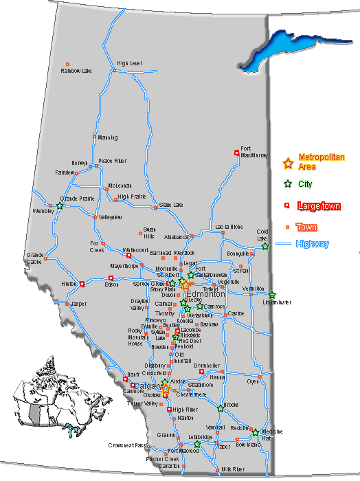
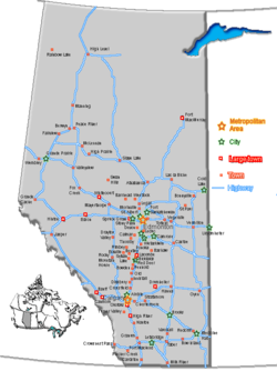 Distribution of town and cities in Alberta.
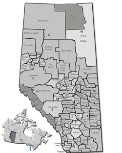 Rural and specialized municipalities of Alberta
The Province of Alberta, Canada, is divided into 10 different types of municipalities – urban municipalities (including cities, towns, villages and summer villages), specialized municipalities, rural municipalities (including municipal districts/counties, improvement districts and special areas), Métis settlements, and Indian reserves. All types of municipalities are governed by local residents and were incorporated under various provincial acts, with the exception of improvement districts (governed by either the provincial or federal government), and Indian reserves (governed by local First Nations people under federal jurisdiction).
Alberta also has numerous unincorporated communities (including urban services areas, hamlets and a townsite) that are not independent municipalities in their own right. However, they are all recognized as sub-municipal entities by Alberta Municipal Affairs under the jurisdiction of specialized municipalities or rural municipalities, with the exception of the lone townsite (its jurisdiction is shared with an Indian reserve that surrounds it).
With the exception of Métis settlements, Statistics Canada recognizes all of Alberta’s municipalities as census subdivisions and groups them into 19 census divisions based on geography. Within census divisions, Statistics Canada groups some of Alberta’s municipalities/census subdivisions into two census metropolitan areas (CMAs) or 12 census agglomerations (CAs) for enumeration purposes. All CMAs include large urban centres and surrounding census subdivisions. All CAs also include large urban centres and in some cases their surrounding census subdivisions.
With the exception of Indian reserves, the administration of municipalities in Alberta is regulated by the Municipal Government Act,[1] the Special Areas Act[2] and the Metis Settlements Act.[3]
As of 2009, the combined unofficial population of all of Alberta’s municipalities was 3,584,648. [4]
Contents
Urban municipalities
Cities
Main article: List of cities in AlbertaAccording to Section 82 of the Municipal Government Act (MGA), an area may incorporate as a city if:
- it has a population of 10,000 people or more; and
- the majority of its buildings are on parcels of land smaller than 1,850 m².[1]
Essentially, cities are formed from urban communities with populations of at least 10,000 people.[5]
Alberta currently has a total of 16 cities with a combined population totalling 2,367,320 as of 2009.[4]
Cities of Alberta City Incorporation
Date (city)Council
Size[6]Region Area (km²,
2008)[6]Population[7] Census
Year[7]Airdrie January 1, 1985 7 Calgary Region 34 39,822 2010 Brooks September 1, 2005 7 Southern Alberta 38 13,581 2007 Calgary January 1, 1894 15 Calgary Region [N 1] 848 1,071,515 2010 Camrose January 1, 1955 9 Central Alberta 32 16,543 2008 Cold Lake October 1, 2000 7 Central Alberta 60 13,924 2009 Edmonton October 8, 1904 13 Edmonton Capital Region [N 1] 700 782,439 2009 Fort Saskatchewan July 1, 1985 7 Edmonton Capital Region 48 18,653 2010 Grande Prairie January 1, 1958 9 Northern Alberta 73 50,227 2007 Lacombe September 5, 2010 7 Central Alberta 18 11,733 2009 Leduc September 1, 1983 7 Edmonton Capital Region 38 23,293 2010 Lethbridge May 9, 1906 9 Southern Alberta 124 86,659 2010 Lloydminster January 1, 1958 7 Central Alberta 42 26,502 [N 2] 2009 Medicine Hat May 9, 1906 9 Southern Alberta 120 61,097 2009 Red Deer March 25, 1913 9 Central Alberta 76 90,084 2010 Spruce Grove March 1, 1986 7 Edmonton Capital Region 32 24,646 2010 St. Albert January 1, 1977 7 Edmonton Capital Region 50 60,138 2010 Wetaskiwin May 9, 1906 7 Central Alberta 17 12,285 2009 Notes:
- ^ a b Census metropolitan areas are formed around Calgary and Edmonton; census agglomerations are formed around Brooks,[8] Camrose,[9] Cold Lake,[10] Grande Prairie,[11] Lethbridge,[12] Lloydminster,[13] Medicine Hat,[14] Red Deer,[15] and Wetaskiwin.[16]
- ^ Includes 9,100 in the Saskatchewan portion of Lloydminster.
Towns
Main article: List of towns in AlbertaAccording to Section 81 of the Municipal Government Act (MGA), an area may incorporate as a town if:
- it has a population of 1,000 people or more; and
- the majority of its buildings are on parcels of land smaller than 1,850 m².[1]
Essentially, towns are formed from urban communities with populations of at least 1,000 people. When a town's population exceeds 10,000 people, its council may apply to change its status to that of a city, but the change in incorporated status is not mandatory.[5]
Communities with shrinking populations are allowed to retain town status even if the number of residents falls below the 1,000 limit. Some of Alberta's towns have never reached a population of 1,000 people, but were incorporated as towns before the current requirement to have a population of 1,000 or more.
Alberta currently has a total of 109 towns, with a combined population totalling 446,791 as of 2009.[4]
Towns of Alberta Name Surrounding/Adjacent
Specialized or Rural Municipality [17] [18]Area
(km²)
[19]Latest Municipal
Census Population
(2007-2010) [7]Latest Federal
Census Population
(2006) [20]Remarks Athabasca Athabasca County 16.83 2,734 2,575 Municipal seat
Formerly known as Athabasca Landing prior to August 4, 1913[21]Banff I.D. No. 9 (Banff) 3.95 8,721 6,700 latest municipal census population includes a shadow (non-permanent) population of 1,284[7] Barrhead Barrhead No. 11, County of 7.77 4,209 Municipal seat Bashaw Camrose County 3.08 868 796 Bassano Newell, County of 3.98 1,390 1,345 Beaumont Leduc County 10.35 12,586 8,961 Beaverlodge Grande Prairie No. 1, County of 5.28 2,264 Bentley Lacombe County 2.48 1,132 1,083 Black Diamond Foothills No. 31, M.D. of 1.93 2,308 1,900 Blackfalds Lacombe County 7.60 5,610 4,571 Bon Accord Sturgeon County 2.05 1,534 Bonnyville Bonnyville No. 87, M.D. of 16.75 6,470 5,832 Municipal seat Bow Island Forty Mile No. 8, County of 5.74 1,868 1,790 Bowden Red Deer County 3.04 1,236 1,205 Bruderheim Lamont County 4.55 1,215 Calmar Leduc County 4.21 2,033 1,959 Canmore Bighorn No. 8, M.D. of 67.36 12,226 12,039 Cardston Cardston County 8.44 3,578 3,452 Municipal seat Carstairs Mountain View County 11.00 2,656 Castor Paintearth No. 18, County of 2.73 931 Municipal seat Chestermere Rocky View County 8.23 14,285 9,564 Formerly known as Chestermere Lake prior to March 1, 1993[22] Claresholm Willow Creek No. 26, M.D. of 7.81 3,700 Coaldale Lethbridge, County of 7.98 6,943 6,177 Coalhurst Lethbridge, County of 1.98 1,953 1,523 Cochrane Rocky View County 31.00 15,424 13,760 Coronation Paintearth No. 18, County of 3.69 1,015 Crossfield Rocky View County 4.62 2,861 2,648 Daysland Flagstaff County 1.66 818 Devon Leduc County 11.82 6,534 6,256 Didsbury Mountain View County 15.37 4,599 4,275 Municipal seat Drayton Valley Brazeau County 13.10 6,893 Municipal seat Drumheller Kneehill County
Special Area No. 2
Starland County
Wheatland County112.53 7,932 Reverted from city status as a result of its amalgamation with the M.D. of Badlands No. 7 in 1997[23] Eckville Lacombe County 1.61 1,002 951 Edson Yellowhead County 26.33 8,098 Municipal seat Elk Point St. Paul No. 19, County of 1.94 1,512 1,487 Fairview Fairview No. 136, M.D. of 9.90 3,297 Municipal seat Falher Smoky River No. 130, M.D. of 2.66 941 Municipal seat Fort Macleod Willow Creek No. 26, M.D. of 23.31 3,072 Formerly known as Macleod prior to April 1, 1952[24] Fox Creek Greenview No. 16, M.D. of 8.56 2,278 Gibbons Sturgeon County 7.51 2,848 2,642 Grande Cache Greenview No. 16, M.D. of 35.84 3,783 Granum Willow Creek No. 26, M.D. of 1.79 445 415 Formerly known as Leavings prior to March 31, 1908[25] Grimshaw Peace No. 135, M.D. of 3.94 2,537 Hanna Special Area No. 2 8.19 2,847 Municipal seat Hardisty Flagstaff County 4.16 760 High Level Mackenzie County 20.86 3,887 High Prairie Big Lakes, M.D. of 5.38 2,836 2,750 Municipal seat High River Foothills No. 31, M.D. of 12.84 11,783 10,716 Municipal seat Hinton Yellowhead County 23.90 9,825 9,738 Innisfail Red Deer County 8.48 7,883 7,316 Irricana Rocky View County 2.73 1,243 Killam Flagstaff County 3.15 1,019 Lamont Lamont County 4.03 1,664 Municipal seat Legal Sturgeon County 3.12 1,192 Magrath Cardston County 5.68 2,302 2,081 Manning Northern Lights, County of 2.58 1,493 Municipal seat Mayerthorpe Lac Ste. Anne County 3.80 1,474 McLennan Smoky River No. 130, M.D. of 3.30 824 Milk River Warner No. 5, County of 2.33 846 816 Millet Wetaskiwin No. 10, County of 3.57 2,068 Morinville Sturgeon County 11.34 7,636 6,775 Municipal seat Mundare Lamont County 4.27 823 712 Nanton Willow Creek No. 26, M.D. of 3.17 2,124 2,055 Okotoks Foothills No. 31, M.D. of 19.59 23,201 17,145 Olds Mountain View County 15.03 7,248 Onoway Lac Ste. Anne County 3.11 1,021 875 Oyen Special Area No. 3 4.62 1,190 1,015 Peace River Northern Lights, County of
Northern Sunrise County
Peace No. 135, M.D. of27.81 6,315 Municipal seat
Formerly known as Peace River Crossing prior to May 22, 1916[26]Penhold Red Deer County 2.59 2,322 1,961 Picture Butte Lethbridge, County of 2.84 1,658 1,592 Pincher Creek Pincher Creek No. 9, M.D. of 9.45 3,712 3,625 Municipal seat Ponoka Ponoka County 13.35 6,576 Municipal seat Provost Provost No. 52, M.D. of 4.48 2,072 Municipal seat Rainbow Lake Mackenzie County 11.00 1,082 965 Raymond Warner No. 5, County of 4.90 3,868 3,205 Redcliff Cypress County 10.49 5,096 Redwater Sturgeon County 20.27 2,192 Rimbey Ponoka County 10.97 2,496 2,252 Rocky Mountain House Clearwater County 12.93 7,231 6,874 Municipal seat Sedgewick Flagstaff County 2.78 891 Municipal seat Sexsmith Grande Prairie No. 1, County of 3.47 2,255 1,959 Slave Lake Lesser Slave River No. 124, M.D. of 16.15 7,031 6,703 Municipal seat Smoky Lake Smoky Lake County 3.89 1,010 Municipal seat Spirit River Spirit River No. 133, M.D. of 2.28 1,148 Municipal seat St. Paul St. Paul No. 19, County of 5.51 5,632 5,106 Municipal seat
Formerly known as St. Paul de Métis prior to December 15, 1932Stavely Willow Creek No. 26, M.D. of 1.34 497 435 Stettler Stettler No. 6, County of 9.77 5,843 5,418 Municipal seat Stony Plain Parkland County 36.63 14,177 12,363 Strathmore Wheatland County 15.74 12,139 10,225 Municipal seat Sundre Mountain View County 7.79 2,518 Swan Hills Big Lakes, M.D. of 25.66 1,858 1,645 Sylvan Lake Red Deer County 15.55 11,115 10,208 Taber Taber, M.D. of 15.66 7,821 7,591 Municipal seat Three Hills Kneehill County 5.62 3,322 3,089 Municipal seat Tofield Beaver County 6.58 1,876 Trochu Kneehill County 2.02 1,113 1,005 Turner Valley Foothills No. 31, M.D. of 5.70 2,022 1,908 Two Hills Two Hills No. 21, County of 3.49 1,232 1,047 Municipal seat Valleyview Greenview No. 16, M.D. of 7.39 1,884 1,725 Municipal seat Vauxhall Taber, M.D. of 2.59 1,069 Vegreville Minburn No. 27, County of 13.48 5,834 5,519 Municipal seat Vermilion Vermilion River, County of 13.56 4,472 4,036 Viking Beaver County 1.99 1,085 Vulcan Vulcan County 6.13 1,940 Wainwright Wainwright No. 61, M.D. of 9.17 5,775 5,426 Municipal seat Wembley Grande Prairie No. 1, County of 4.82 1,443 Westlock Westlock County 13.72 4,964 5,008 Whitecourt Woodlands County 28.50 9,202 8,971 Municipal seat Villages
Main article: List of villages in AlbertaAccording to Section 80 of the Municipal Government Act (MGA), an area may incorporate as a village if:
- it has a population of 300 people or more; and
- the majority of its buildings are on parcels of land smaller than 1,850 m².[1]
Essentially, villages are formed from urban communities with populations of at least 300 people. When a village's population exceeds 1,000 people, its council may apply to change its status to that of a town, but the change in incorporated status is not mandatory.
Communities with shrinking populations are allowed to retain village status even if the number of residents falls below the 300 limit. Some of Alberta's villages have never reached a population of 300 people, but were incorporated as villages before there was a requirement to have a population of 300 or more.
Alberta currently has a total of 95 villages, with a combined population totalling 39,347 as of 2009.[4] These numbers reflect the recent dissolution of the villages of Derwent and New Sarepta to hamlet status on September 1, 2010.[27][28]
Summer villages
Main article: List of summer villages in AlbertaAccording to former Section 79 of the Municipal Government Act (MGA), a summer village is an area that:
- has at least 60 parcels of land developed with dwelling buildings; and
- has a population of less than 300 persons where the majority of the persons who would be electors do not permanently reside in that area.
As a result of Section 79 being repealed,[1] summer villages can no longer be formed in Alberta.[5]
Essentially, summer villages were once formed from urban communities with populations of less than 300 people and significant non-permanent populations. When a summer village's population exceeds 300 people, its council may apply to change its status to that of a village, but the change in incorporated status is not mandatory.
Alberta currently has a total of 51 summer villages, with a combined population totalling 6,152 as of 2009.[4]
Summer Villages of Alberta Summer Village Name Incorporation Date[36] Area (km²)[37] Population (2006)[37][38] Argentia Beach January 1, 1967 0.69 52 Betula Beach January 1, 1960 0.18 15 Birch Cove December 31, 1988 0.29 38 Birchcliff January 1, 1972 0.98 125 Bondiss January 1, 1983 1.33 131 Bonnyville Beach January 1, 1958 0.38 97 Burnstick Lake December 31, 1991 0.18 43 Castle Island January 1, 1955 0.05 22 Crystal Springs January 1, 1957 0.58 112 Ghost Lake December 31, 1953 0.63 78 Golden Days January 1, 1965 2.27 207 Grandview January 1, 1967 0.80 127 Gull Lake March 1, 1913 0.70 204 Half Moon Bay January 1, 1978 0.17 32 Horseshoe Bay January 1, 1985 1.04 214 Island Lake January 1, 1958 1.45 351 Island Lake South January 1, 1983 0.63 105 Itaska Beach June 30, 1953 0.28 35 Jarvis Bay January 1, 1986 0.55 183 Kapasiwin September 1, 1993 0.31 15 Lakeview October 25, 1913 0.33 36 Larkspur January 1, 1985 0.22 56 Ma-Me-O-Beach December 31, 1948 0.65 155 Mewatha Beach January 1, 1978 0.78 167 Nakamun Park January 1, 1966 0.41 88 Norglenwold January 1, 1965 0.67 270 Norris Beach December 31, 1988 0.16 40 Parkland Beach January 1, 1984 0.93 135 Pelican Narrows July 1, 1979 0.70 141 Point Alison December 31, 1950 0.16 15 Poplar Bay January 1, 1967 0.76 84 Rochon Sands May 17, 1929 2.32 66 Ross Haven January 1, 1962 0.70 198 Sandy Beach January 1, 1956 2.43 239 Seba Beach August 2, 1920 0.66 203 Silver Beach December 31, 1953 0.66 47 Silver Sands January 1, 1969 2.35 173 South Baptiste January 1, 1983 1.05 69 South View January 1, 1970 0.69 115 Sunbreaker Cove December 31, 1990 0.49 137 Sundance Beach January 1, 1970 0.42 102 Sunrise Beach December 31, 1988 1.72 170 Sunset Beach May 1, 1977 0.99 88 Sunset Point January 1, 1959 1.11 242 Val Quentin January 1, 1966 0.30 181 Waiparous January 1, 1986 0.41 49 West Baptiste January 1, 1983 0.60 104 West Cove January 1, 1963 1.21 169 Whispering Hills January 1, 1983 1.73 125 White Sands January 1, 1980 1.60 120 Yellowstone January 1, 1965 0.28 170 Specialized municipalities
Main article: Specialized municipalities of AlbertaAccording to Section 83 of the Municipal Government Act (MGA), a municipality may incorporate as a specialized municipality under one of the following three scenarios:
- where the Minister of Alberta Municipal Affairs (AMA) is satisfied that the other incorporated statuses under the MGA do not meet the needs of the municipality's residents;
- to form a local government that, in the opinion of the Minister of AMA, will provide for the orderly development of the municipality in a similar fashion to the other incorporated statuses within the MGA; or
- for any other circumstances that are deemed appropriate by the Minister of AMA.[1]
Essentially, specialized municipalities are municipalities that are unconventional in nature compared to other municipalities in Alberta, and they are incorporated under the authority of the existing MGA instead of relying on the creation of their own separate acts (i.e., the Special Areas Act[2] allowed the incorporation of Alberta's three special areas and the Metis Settlements Act[3] allowed the incorporation of Alberta's eight Métis settlements).[5]
Alberta's five specialized municipalities have a combined population totalling 198,444 as of 2009.[4]
Specialized municipalities of Alberta Specialized Municipality Incorporation
Date[39]Council
Size[39]Region Area (km²,
2008)[39]Population[7] Census
Year[7]Reason for incorporation as
a specialized municipalityCrowsnest Pass, Municipality of January 16, 2008 7 Southern Alberta 194 5,749 2006 No specific reason provided in order in council that changed its status.[40] Jasper, Municipality of July 20, 2001 7 Alberta's Rockies 736 4,745 2008 To provide for the unique needs of residents living within the municipality.[41] Mackenzie County June 23, 1999 10 Northern Alberta 77,616 10,002 2006 To address concerns about municipal government and management in a municipality that serves a number of unique communities within a very large territory.[42] Strathcona County January 1, 1996 9 Edmonton Capital Region 1,213 87,998 2009 To provide for the unique needs of a municipality that includes both a large urban centre and a significant rural territory and population.[43] Wood Buffalo, Regional Municipality of April 1, 1995 11 Northern Alberta 68,454 91,612 2007 To provide for the unique needs of a municipality including a large urban centre and a large rural territory with a small population.[44] Rural municipalities
Municipal districts (a.k.a counties)
Main article: List of municipal districts in AlbertaAccording to Section 78 of the Municipal Government Act (MGA), a municipal district is an area in which:
- the majority of the buildings used as dwellings are on parcels of land with an area of at least 1,850 m²; and
- there is a population of 1,000 or more.[1]
Essentially, municipal districts are large rural areas in which their citizens reside on farms, country residential subdivisions or unincorporated communities (i.e., hamlet, localities and other settlements).[5]
In Alberta, the term county is synonymous with the term municipal district – it is not its own incorporated municipal status that is different than that of a municipal district. As such, Alberta Municipal Affairs provides municipal districts with the opportunity to brand themselves either as municipal districts or counties in their official names.
Of Alberta's 64 municipal districts, 46 of them brand themselves as counties. Over the past decade, Alberta has observed a trend of numerous municipal districts rebranding themselves as counties through official name changes. Some of the reasons why a municipal district would rebrand itself as a county include that the term county is: more recognizable by the general public; has a more modern and progressive appeal; and is more marketable from an economic development perspective.
The last municipal district (M.D.) to rebrand itself as a county was the M.D. of Northern Lights No. 22, which was renamed as the County of Northern Lights on February 3, 2010.[45]
Alberta's 64 municipal districts have a combined population totalling 446,848 as of 2009.[4]
Improvement districts
According to Section 581 of the Municipal Government Act (MGA), Alberta's Lieutenant Governor in Council, on the recommendation of the Minister of Municipal Affairs, may form an improvement district. Section 582 of the MGA requires that the order to form an improvement district must describe its boundaries and give it an official name.
Alberta currently has seven improvement districts. Five of them are located within national parks, while the remaining two are within provincial parks. The official names of the seven improvements districts, and the national or provincial parks they are within, are as follows:
- Improvement District No. 4 Waterton within Waterton Lakes National Park;
- Improvement District No. 9 Banff within Banff National Park;
- Improvement District No. 12 Jasper within Jasper National Park;
- Improvement District No. 13 Elk Island within Elk Island National Park;
- Improvement District No. 24 Wood Buffalo within the Alberta portion of Wood Buffalo National Park;
- Improvement District No. 25 Willmore Wilderness within Willmore Wilderness Park; and
- Kananaskis Improvement District (No. 5) mostly consisting of the Kananaskis Country park system.
Alberta's seven improvement districts have a combined population totalling 1,994 as of 2009.[4]
In September 2011, the Province of Alberta approved the future formation of a new improvement district named Improvement District No. 349.[50] It will be located north of the City of Cold Lake and will include the Cold Lake Air Weapons Range from Lac La Biche County and some adjacent lands further to the north from the Regional Municipality of Wood Buffalo.[51][52][50] The effective incorporation date of Improvement District No. 349 will be January 1, 2012.[50]
Special areas
Main article: Special Areas BoardSpecial areas are rural municipalities created in 1938 under the authority of the Special Areas Act.[2][5] A special area is not to be confused with a specialized municipality, which is a completely different municipal status.
Alberta's three special areas had a combined population totalling 4,729 in 2006.[4]
Special Areas of Alberta Official name Population Dwellings Area Density (2001) (2006) Special Area No. 2 2,331[53] 2,074[54] 775 9,342.59 km2 (3,607.2 sq mi) 0.2/km2 (0.6/sq mi) Special Area No. 3 1,469[55] 1,266[56] 481 6,623.96 km2 (2,557.5 sq mi) 0.2/km2 (0.5/sq mi) Special Area No. 4 1,514[57] 1,389[58] 493 4,403.23 km2 (1,700.1 sq mi) 0.3/km2 (0.8/sq mi) Unincorporated communities
Main article: List of unincorporated communities in AlbertaUrban service areas
An urban service area is a type of hamlet that is not officially defined under the Municipal Government Act (MGA). However, the Province of Alberta recognizes it as equivalent to a city for the purposes of program delivery and grant eligibility according to the Orders in Council that established the Regional Municipality (R.M.) of Wood Buffalo and Strathcona County as specialized municipalities.[59][60]
These Orders in Council (see Schedule 1, Section 7[59] and Schedule 1, Section 3[60] respectively) also state that:
- the specialized municipalities shall provide to the Province of Alberta any information required to administer programs or to determine the amount of grants which would have been paid if the urban service areas were incorporated cities; and
- for the purposes of enactments affecting roads, culverts, ditches, drains, and highways, the urban service areas are deemed to be cities.
Essentially, urban services areas meet the eligibility requirements of the MGA to incorporate as a city. As such, they are Alberta's largest hamlets.
There are currently two urban services areas in Alberta:
- Fort McMurray; and
- Sherwood Park.
Fort McMurray, within the jurisdiction of the R.M. of Wood Buffalo, was formerly a city prior its amalgamation with Improvement District No. 143 on April 1, 1995. It was designated an urban service area at the time of the amalgamation.[59]
Sherwood Park has always been an unincorporated community under the jurisdiction of Strathcona County. It became an urban service area when Strathcona County changed its status from a municipal district to a specialized municipality on January 1, 1996.[60]
Hamlets
Main article: List of hamlets in AlbertaAccording to Section 59 of the Municipal Government Act (MGA), hamlets are unincorporated communities that:
- consist of five or more buildings used as dwellings, a majority of which are on parcels of land smaller than 1,850 m²;
- have a generally accepted boundary and name; and
- contain parcels of land that are used for non‑residential purposes.[1]
Further, Section 59 of the MGA provides the councils of municipal districts (or counties) and specialized municipalities the authority to designate unincorporated communities within its boundaries as hamlets.[1][5] Hamlets may also be designated within improvement districts and special areas by the Minister of Municipal Affairs pursuant to Section 590 of the MGA and Section 10 of the Special Areas Act respectively.[1][2]
When a hamlet's population reaches 300, it becomes eligible to incorporate as a village under Section 80 of the MGA, so long as the majority of the buildings are still on parcels of land smaller than 1,850 m².[1] However, it is a modern-day rarity for a hamlet to incorporate as a village – Barnwell and Wabamun were the last two to do so both on January 1, 1980. It is much more common these days for villages to revert to hamlet status through the dissolution process instead.
There are currently 386 hamlets in Alberta, two of which are the urban services areas presented above.
Townsites
A townsite is a type of unincorporated community that is not officially defined under the Municipal Government Act (MGA), but it is generally regarded as an independent urban area within an Indian reserve that is comparable in population, land area, services, and built form, to that of Alberta's incorporated towns. Essentially, townsites would meet the eligibility requirements of the MGA to incorporate as a town if they were not located on Indian reserve lands under federal jurisdiction.
Redwood Meadows is Alberta's only townsite at this time and is located within the Tsuu T'ina Nation.
Métis settlements
Main article: Métis in AlbertaMétis settlements are rural areas inhabited by members of Alberta's Métis Nation that were established in 1936 under the Métis Population Betterment Act. The settlements provide an autonomous land base, allow better access to education, health and other social services, and provide economic development opportunities for Alberta's Métis Nation.[3] Métis settlements now operate under the authority of the Metis Settlements Act.[5]
Alberta currently has eight Métis settlements, all of which are located in the northern half of the province. The official names of the eight settlements, and the municipal districts they are within, are as follows:
Métis Settlements of Alberta Settlement
NameArea* Population
(2009)[4](km²) (acres) Buffalo Lake Métis Settlement 353.8 87,420 1,206 East Prairie Métis Settlement 333.8 82,480 906 Elizabeth Métis Settlement 261.8 64,690 820 Fishing Lake Métis Settlement 386.3 95,464 952 Gift Lake Métis Settlement 861.6 212,916 999 Kikino Métis Settlement 456.0 112,675 1,113 Paddle Prairie Métis Settlement 1,728.9 427,214 1,089 Peavine Métis Settlement 840.0 207,577 905 - *Areas generated from provincial Métis settlement boundary data.
Very small portions of the Gift Lake Métis Settlement and the Kikino Métis Settlement are also located within Northern Sunrise County and Lac La Biche County respectively.
Alberta's eight Métis settlements have a combined population totalling 7,990 as of 2009.[4]
Indian reserves
Main article: List of Indian reserves in AlbertaReserves in Alberta cover a total area of 1,622,630 acres (6,566.6 km2) and range from 1,089 acres (4.41 km2) to 354,667 acres (1,435.29 km2) in size.[5] Under the British North America Act, legislative authority over Indian reserves is placed exclusively with the national parliament, specifically Department of Indian and Northern Affairs Canada (INAC). Local administration is placed with local native governments.
Indian Reserves of Alberta Reserve
NameNo. Treaty
No.[82]Nation Area (km) Population (2001)[83] Alexander 134
134a
134b6 Alexander First Nation 68.71
-
-815
-
-Alexis 133 6 Alexis Nakota Sioux Nation 54.66 800 Alexis Cardinal River Indian Reserve 234 6 Alexis Nakota Sioux Nation - - Alexis Elk River Indian Reserve 233 6 Alexis Nakota Sioux Nation - - Alexis Whitecourt Indian Reserve 232 6 Alexis Nakota Sioux Nation - - Allison Bay 219 8 Mikisew Cree First Nation - - Amber River 211 8 Dene Tha' First Nation 17.41 111 Assineau River 150f 8 Swan River First Nation - - Beaver Lake 131 6 Beaver Lake Cree Nation 56.71 390 Beaver Ranch 163
163a
163b8 Tallcree 9.36
-
-18
-
-Big Horn 144a 7 Stoney Nations (Bearspaw, Chiniki, Wesley) 22.24 192 Bistcho Lake 213 8 Dene Tha' First Nation - - Blood 148
148a7 Blood (Kainai Nation) 1,414.03
18.323,852
5Blue Quills First Nation Indian Reserve - 6 Beaver Lake Cree Nation,
Cold Lake First Nations,
Frog Lake,
Heart Lake,
Kehewin Cree Nation,
Saddle Lake- - Boyer 164 8 Beaver First Nation (Dunneza) - - Buck Lake 133c 6 Paul - - Bushe River 207 8 Dene Tha' First Nation 111.94 318 Cadotte Lake Indian Settlement - 8 Woodland Cree First Nation - - Charles Lake 225 8 Mikisew Cree First Nation 0.66 - Child Lake 164a 8 Beaver First Nation 27.87 156 Chipewyan 201
201a
201b
210c
201d
210e
210f
201g8 Athabasca Chipewyan First Nation 261.74
0.28
0.34
0.53
0.23
0.31
0.75
8.34- Clear Hills 152c 8 Horse Lake First Nation 14.34 15 Clearwater 175 8 Fort Mcmurray #468 First Nation 7.99 - Cold Lake 149
149a
149b
149c6 Cold Lake First Nations 141.07
0.80
41.64
-439
39
110
-Collin Lake 223 8 Mikisew Cree First Nation 0.48 - Cornwall Lake 224 8 Mikisew Cree First Nation 1.40 - Cowper Lake Indian Reserve 194a 8 Chipewyan Prairie First Nation - - Desmarais Settlement - 8 Bigstone Cree Nation 1.44 112 Devil's Gate 220 8 Mikisew Cree First Nation 17.48 - Dog Head 218 8 Mikisew Cree First Nation 0.47 93 Drift Pile River 150 8 Driftpile First Nation 66.46 655 Duncan's 151a 8 Duncan's First Nation 17.16 121 Eden Valley 216 7 Stoney Nations (Bearspaw, Chiniki, Wesley) 17.48 509 Ermineskin 138 6 Ermineskin Tribe 104.55 - Fort Mckay 174
174c8 Fort Mckay First Nation 8.17
0.72437
-Fort Vermilion 173b 8 Tallcree - - Fox Lake 162 8 Little Red River Cree Nation 95.74 1,254 Garden Creek Indian Settlement - 8 Little Red River Cree Nation - - Gregoire Lake 176
176a
176b8 Fort Mcmurray #468 First Nation 21.79
0.71
-105
133
-Hay Lake 209 8 Dene Tha' First Nation - - Heart Lake 167
167a6 Heart Lake 108.55
47.47915
124Hokedhe Túe Indian Reserve 196e 8 Smith's Landing First Nation - - Horse Lakes 152b 8 Horse Lake First Nation 14.44 324 Jackfish Point 214 8 Dene Tha' First Nation - - Janvier 194 8 Chipewyan Prairie First Nation 16.25 252 Jean Baptiste Gambler 183 8 Bigstone Cree Nation 1.90 169 John D'Or Prairie 215 8 Little Red River Cree Nation 146.06 851 K'i Túe Indian Reserve 196d 8 Smith's Landing First Nation - - Kapawe'no First Nation 229 8 Kapawe'no First Nation - - Kapawe'no First Nation 231 8 Kapawe'no First Nation - - Kapawe'no First Nations Lands (Freeman) 150b 8 Kapawe'no First Nation 0.48 62 Kapawe'no First Nations Lands (Grouard) 230 8 Kapawe'no First Nation 8.04 - Kapawe'no First Nations Lands (Halcro) 150c 8 Kapawe'no First Nation 0.38 - Kapawe'no First Nations Lands (Pakashan) 150d 8 Kapawe'no First Nation 3.80 5 Kehiwin 123 6 Kehewin Cree Nation 79.56 991 Li Dezé Indian Reserve 196c 8 Smith's Landing First Nation - - Little Buffalo - 8 Lubicon Lake Indian Nation 11.92 - Loon Lake Indian Reserve 235 8 Loon River Cree - - Loon Prairie Indian Reserve 237 8 Loon River Cree - - Louis Bull 138b 6 Louis Bull 31.51 892 Montana 139 6 Montana 28.18 580 Namur Lake 174a
174b8 Fort Mckay First Nation 23.35
32.32-
-O'chiese 203 6 O'chiese 142.08 504 O'chiese Cemetery 203a 6 O'chiese - - Old Fort 217 8 Mikisew Cree First Nation - - Peace Point 222 8 Mikisew Cree First Nation - - Peigan 147 7 Piikani Nation 430.31 1,537 Peigan Timber Limit "B" - 7 Piikani Nation - - Pigeon Lake 138a 6 Ermineskin Tribe,
Louis Bull,
Montana,
Samson- - Puskiakiwenin 122 6 Frog Lake 100.42 432 Saddle Lake 125 6 Saddle Lake 274.69 8,000+ Samson 137
137a6 Samson 128.06
1.311,069
15Sandy Point 221 8 Mikisew Cree First Nation 4.04 - Sawridge 150g
150h8 Sawridge 9.25
13.6759
10Siksika 146 7 Siksika Nation - - Stoney 142
143
1447 Stoney Nations (Bearspaw, Chiniki, Wesley) 402.26 2,173 Stony Plain 135
135a6 Enoch Cree Nation #440 51.61
-1,100
-Sturgeon Lake 154
154a
154b8 Sturgeon Lake Cree Nation 85.97
2.44
-871
15
-Sucker Creek 150a 8 Sucker Creek Cree First Nation 67.84 549 Sunchild 202 6 Sunchild First Nation 53.38 598 Swampy Lake Indian Reserve 236 8 Loon River Cree - - Swan River 150e 8 Swan River First Nation 41.36 307 Tall Cree 173
173a8 Tallcree 6.15
32.06173
183Thabacha Náre Indian Reserve 196a 8 Smith's Landing First Nation - - Thebathi Indian Reserve 196 8 Smith's Landing First Nation - - Tsu K'adhe Túe Indian Reserve 196f
196g8 Smith's Landing First Nation -
--
-Tsuu T'ina Nation 145 7 Tsuu T'ina Nation 283.14 1,982 The Jere Ghaili Indian Reserve 196b 8 Smith's Landing First Nation - - Unipouheos 121 6 Frog Lake 88.27 586 Upper Hay River 212 8 Dene Tha' First Nation 14.10 347 Utikoomak Lake 155
155a
155b8 Whitefish Lake 30.30
7.20
-812
121
-Wabamun 133a
133b6 Paul First Nation 64.45
-998
-Wabasca 166
166a
166b
166c
166d8 Bigstone Cree Nation 84.82
6.32
25.50
35.21
58.9874
510
161
182
860Wadlin Lake Indian Reserve 173c 8 Tallcree - - White Fish Lake 128 6 Saddle Lake
Whitefish Lake (Goodfish)50.49 1,175 William Mckenzie 151k 8 Duncan's First Nation - - Winefred Lake Indian Reserve 194b 8 Chipewyan Prairie First Nation 4.53 - Woodland Cree 226 8 Woodland Cree First Nation 130.96 417 Woodland Cree 227 8 Woodland Cree First Nation - - Woodland Cree 228 8 Woodland Cree First Nation 38.25 97 Zama Lake 210 8 Dene Tha' First Nation - - See also
- List of census divisions of Alberta
- List of designated places in Alberta
- List of ghost towns in Alberta
- List of settlements in Alberta
- List of urban areas in Alberta
References
- ^ a b c d e f g h i j k Alberta Queen's Printer. "Municipal Government Act". http://www.qp.alberta.ca/574.cfm?page=M26.cfm&leg_type=Acts&isbncln=9780779744916. Retrieved 2009-12-06.
- ^ a b c d Alberta Queen's Printer. "Special Areas Act". http://www.qp.alberta.ca/574.cfm?page=S16.cfm&leg_type=Acts&isbncln=0779703685. Retrieved 2009-12-06.
- ^ a b c Alberta Queen's Printer. "Metis Settlements Act". http://www.qp.alberta.ca/574.cfm?page=m14.cfm&leg_type=Acts&isbncln=9780779743704. Retrieved 2009-12-06.
- ^ a b c d e f g h i j k l m n o p q Alberta Municipal Affairs. "Alberta 2009 Official Population List". http://www.municipalaffairs.alberta.ca/documents/LGS/2009pop.pdf. Retrieved 2009-12-15.
- ^ a b c d e f g h i Alberta Municipal Affairs and Housing (2008-05-16). "Types of Municipalities in Alberta". http://municipalaffairs.gov.ab.ca/am_types_of_municipalities_in_alberta.cfm. Retrieved December 18 2008.
- ^ a b "Municipal Profiles (Cities)". Alberta Municipal Affairs. 2010-03-12. http://www.municipalaffairs.alberta.ca/cfml/MunicipalProfiles/basicReport/CITY.PDF. Retrieved 2010-03-15.
- ^ a b c d e f g "2010 Official Population List". Alberta Municipal Affairs. 2010-09-15. http://www.municipalaffairs.alberta.ca/documents/msb/2010pop.pdf. Retrieved 2011-01-18.
- ^ Brooks CA[dead link]
- ^ Camrose CA[dead link]
- ^ Cold Lake CA[dead link]
- ^ Grande Prairie CA[dead link]
- ^ Lethbridge CA[dead link]
- ^ Lloydminster CA[dead link]
- ^ Medicine Hat CA[dead link]
- ^ Red Deer CA[dead link]
- ^ Wetaskiwin CA[dead link]
- ^ Alberta Municipal Affairs (2009-07). "Communities Within Specialized and Rural Municipalities". http://municipalaffairs.gov.ab.ca/documents/ms/commRul.pdf. Retrieved 2009-12-30.
- ^ Alberta Municipal Affairs (2009-12-01). "2009 Municipal Codes". http://municipalaffairs.gov.ab.ca/documents/ms/2009code.pdf. Retrieved 2009-12-30.
- ^ "Municipal Profiles (Towns)". Alberta Municipal Affairs. http://www.municipalaffairs.alberta.ca/cfml/MunicipalProfiles/basicReport/TOWN.PDF. Retrieved 2010-03-21.
- ^ "2006 Community Profiles - Alberta". Statistics Canada. 2006. http://www12.statcan.ca/census-recensement/2006/dp-pd/prof/92-591/search-recherche/lst/page.cfm?Lang=E&GeoCode=48. Retrieved 2007-06-10.
- ^ "The Alberta Gazette - Notice". Alberta Municipal Affairs. 1913-08-04. http://www.municipalaffairs.gov.ab.ca/cfml/pdf_search/pdf/TOWN/0011/Athabasca_Gaz_Notice_Name_%20change_to_Town_of_Athabasca_1913_No17.pdf. Retrieved 2010-07-26.
- ^ "Order in Council (O.C.) 115/93 - Formation of the Summer Village of Chestermere Lake into a Town". Alberta Municipal Affairs. 1993-02-10. http://www.municipalaffairs.gov.ab.ca/cfml/pdf_search/pdf/TOWN/0356/Chestermere_OC_115_93_1993_No6.pdf. Retrieved 2010-07-26.
- ^ "Location and History Profile – Town of Drumheller". Alberta Municipal Affairs. 2009-12-25. http://www.municipalaffairs.alberta.ca/cfml/MunicipalProfiles/index.cfm?fuseaction=BasicReport&MunicipalityType=TOWN&stakeholder=532&profileType=HIST. Retrieved 2010-01-01.
- ^ "Ministerial Order - Change of Name of Town of Macleod to Town of Fort Macleod". Alberta Municipal Affairs. 1952-02-29. http://www.municipalaffairs.gov.ab.ca/cfml/pdf_search/pdf/TOWN/0115/Fort_MacLeod_Gaz_MO_Change_of_Name_to_Fort_MacLeod_1952_No5.pdf. Retrieved 2010-07-26.
- ^ "Leavings to Granum - Alteration of Name of Village". Alberta Municipal Affairs. 1908-03-31. http://www.municipalaffairs.gov.ab.ca/cfml/pdf_search/pdf/TOWN/0135/Granum_Gaz_Alteration_of_Name_of_Village_from_Leavings_to_Granum_1908_No7%20.pdf. Retrieved 2010-07-26.
- ^ "The Alberta Gazette, Vol. 12, No. 10 – Change in Name of Village". Alberta Municipal Affairs. 1916-05-31. http://www.municipalaffairs.gov.ab.ca/cfml/pdf_search/pdf/TOWN/0247/Peace_River_Gaz_Change_of_Name_from_Peace_River_Crossing_to_Peace_River_1916_No29.pdf. Retrieved 2010-07-26.
- ^ a b Alberta Queen's Printer. "Order in Council (O.C.) 229/2010". http://www.qp.alberta.ca/documents/orders/orders_in_council/2010/710/2010_229.html. Retrieved 2010-07-15.
- ^ a b Alberta Queen's Printer. "Order in Council (O.C.) 230/2010". http://www.qp.alberta.ca/documents/orders/orders_in_council/2010/710/2010_230.html. Retrieved 2010-07-15.
- ^ Alberta Municipal Affairs (2009-07). "Communities Within Specialized and Rural Municipalities". http://municipalaffairs.gov.ab.ca/documents/ms/commRul.pdf. Retrieved 2010-01-01.
- ^ Alberta Municipal Affairs (2009-12-01). "2009 Municipal Codes". http://municipalaffairs.gov.ab.ca/documents/ms/2009code.pdf. Retrieved 2010-01-01.
- ^ a b "2006 Community Profiles - Alberta". Statistics Canada. 2006. http://www12.statcan.ca/census-recensement/2006/dp-pd/prof/92-591/search-recherche/lst/page.cfm?Lang=E&GeoCode=48. Retrieved 2010-01-01.
- ^ "Order in Council (O.C.) 979/11". Alberta Municipal Affairs. 1911-12-16. http://www.municipalaffairs.gov.ab.ca/cfml/pdf_search/pdf/VILG/0029/BitternLake_OC_979_1911_No6.pdf. Retrieved 2010-07-26.
- ^ "Change in Name of Village Municipality - Highland to Delia". Alberta Municipal Affairs. 1915-12-09. http://www.municipalaffairs.gov.ab.ca/cfml/pdf_search/pdf/VILG/0084/Delia_Gaz_Change_Name_in_Village_1915_No1.pdf. Retrieved 2010-07-26.
- ^ Village of Ryley. "The Village of Ryley - Equity". http://www.ryley.ca/content/view/225/. Retrieved 2010-04-13.
- ^ "Order in Council (O.C.) 517/98". Alberta Municipal Affairs. 1998-12-09. http://www.qp.alberta.ca/documents/orders/Orders_in_Council/1998/1298/98-517.html. Retrieved 2010-07-26.
- ^ "Summer Village Incorporation Dates". Association of Summer Villages of Alberta. http://www.albertasummervillages.org/welcome.html#section3. Retrieved 2009-12-20.
- ^ a b "2006 Population and dwelling counts for Alberta census subdivisions". Statistics Canada. http://www12.statcan.gc.ca/census-recensement/2006/dp-pd/hlt/97-550/Index.cfm?TPL=P1C&Page=RETR&LANG=Eng&T=302&PR=48&S=1&O=A&RPP=25. Retrieved 2009-12-20.
- ^ a b c d e f g "2006 Census corrections and updates". Statistics Canada. http://www12.statcan.ca/english/census06/corrections/updatepages/cgen001.cfm?lvl=H. Retrieved 2009-12-20.
- ^ a b c "Municipal Profiles (Specialized Municipalities)". Alberta Municipal Affairs. 2010-03-26. http://www.municipalaffairs.alberta.ca/cfml/MunicipalProfiles/basicReport/SMUN.PDF. Retrieved 2010-03-27.
- ^ "Order in Council (O.C.) 1/2008". Province of Alberta. 2008-01-16. http://www.qp.alberta.ca/documents/orders/orders_in_council/2008/108/2008_001.html. Retrieved 2010-03-28.
- ^ "Order in Council (O.C.) 279/2001". Province of Alberta. 2001-07-24. http://www.municipalaffairs.alberta.ca/cfml/pdf_search/pdf/SMUN/0418/Jasper_OC_279_2001_No2.pdf. Retrieved 2010-03-28.
- ^ "Order in Council (O.C.) 264/99". Province of Alberta. 1999-06-23. http://www.municipalaffairs.alberta.ca/cfml/pdf_search/pdf/SMUN/0505/Mackenzie_No_23_OC_%20264_99_1999_No6.pdf. Retrieved 2010-03-28.
- ^ "Order in Council (O.C.) 761/95". Province of Alberta. 1995-12-06. http://www.municipalaffairs.alberta.ca/cfml/pdf_search/pdf/SMUN/0302/Strathcona_County_OC_761_95_1996_No9.pdf. Retrieved 2010-03-28.
- ^ "Order in Council (O.C.) 817/94". Province of Alberta. 1994-12-21. http://www.municipalaffairs.alberta.ca/cfml/pdf_search/pdf/SMUN/0508/Regional_Municipality_of_Wood_Buffalo_OC_817_94_1995_No7.pdf. Retrieved 2010-03-28.
- ^ Province of Alberta (2010-02-03). "Order in Council 24/2010". http://www.qp.alberta.ca/documents/orders/orders_in_council/2010/210/2010_024.html. Retrieved 2010-02-08.
- ^ "Municipal Profiles (Municipal Districts)". Alberta Municipal Affairs. 2010-03-26. http://www.municipalaffairs.alberta.ca/cfml/MunicipalProfiles/basicReport/RMUN.PDF. Retrieved 2010-03-30.
- ^ "Population and Dwelling Counts, for Canada, Provinces and Territories, and Census Subdivisions (Municipalities), 2001 and 1996 Censuses - 100% Data (Alberta)". Statistics Canada. http://www12.statcan.ca/english/census01/products/standard/popdwell/Table-CSD-P.cfm?PR=48. Retrieved 2010-10-06.
- ^ "Population and dwelling counts, for Canada, provinces and territories, and census subdivisions (municipalities), 2006 and 2001 censuses - 100% data". Statistics Canada. 2010-01-06. http://www12.statcan.ca/census-recensement/2006/dp-pd/hlt/97-550/Index.cfm?TPL=P1C&Page=RETR&LANG=Eng&T=302&SR=1&S=1&O=A&RPP=9999&PR=48&CMA=0. Retrieved 2010-10-06.
- ^ a b c d "2006 Census: Corrections and updates". Statistics Canada. 2009-02-09. http://www12.statcan.ca/english/census06/corrections/updatepages/cgen001.cfm?lvl=H. Retrieved 2010-09-26.
- ^ a b c "O.C. 419/2011". Province of Alberta. 2011-09-09. http://www.qp.alberta.ca/documents/orders/orders_in_council/2011/911/2011_419.html. Retrieved 2011-09-12.
- ^ Kostiw, Tanya (2011-08-16). "Air Weapons Range to become improvement district under proposed deal". Bonnyville Nouvelle (Great West Newspapers Limited Partnership). http://www.bonnyvillenouvelle.ca/article/20110816/BNV0801/308169977/-1/bnv/air-weapons-range-to-become-improvement-district-under-proposed-deal. Retrieved 2011-08-16.
- ^ Stodalka, William (2011-08-16). "City council sees draft of potential air range deal". Cold Lake Sun (Sun Media Corporation). http://www.coldlakesun.com/ArticleDisplay.aspx?e=3260280. Retrieved 2011-08-16.
- ^ Special Area 2 - Statistics Canada. 2002. 2001 Community Profiles. Released June 27, 2002. Last modified: November 30, 2005. Statistics Canada Catalogue no. 93F0053XIE.
- ^ "Special Area No. 2 - Community Profile". Statistics Canada. Census 2006. http://www12.statcan.ca/english/census06/data/profiles/community/Details/Page.cfm?Lang=E&Geo1=CSD&Code1=4804004&Geo2=PR&Code2=48&Data=Count&SearchText=Special%20Area%20No.%202&SearchType=Begins&SearchPR=01&B1=All&GeoLevel=&GeoCode=4804004. Retrieved 2010-07-31.
- ^ Special Area 3 - Statistics Canada. 2002. 2001 Community Profiles. Released June 27, 2002. Last modified: November 30, 2005. Statistics Canada Catalogue no. 93F0053XIE.
- ^ "Special Area No. 3 - Community Profile". Statistics Canada. Census 2006. http://www12.statcan.ca/census-recensement/2006/dp-pd/prof/92-591/details/Page.cfm?Lang=E&Geo1=CSD&Code1=4804012&Geo2=PR&Code2=48&Data=Count&SearchText=Special%20Area%20No.%203&SearchType=Begins&SearchPR=48&B1=All&Custom=. Retrieved 2010-07-31.
- ^ Special Area 4 - Statistics Canada. 2002. 2001 Community Profiles. Released June 27, 2002. Last modified: November 30, 2005. Statistics Canada Catalogue no. 93F0053XIE.
- ^ "Special Area No. 4 - Community Profile". Statistics Canada. Census 2006. http://www12.statcan.ca/census-recensement/2006/dp-pd/prof/92-591/details/Page.cfm?Lang=E&Geo1=CSD&Code1=4804020&Geo2=PR&Code2=48&Data=Count&SearchText=Special%20Area%20No.%204&SearchType=Begins&SearchPR=48&B1=All&Custom=. Retrieved 2010-07-31.
- ^ a b c Province of Alberta (1994-12-21). "Order in Council 817/94 (R.M. of Wood Buffalo status change to specialized municipality)". http://www.municipalaffairs.gov.ab.ca/cfml/pdf_search/pdf/SMUN/0508/Regional_Municipality_of_Wood_Buffalo_OC_817_94_1995_No7.pdf. Retrieved February 15, 2010.
- ^ a b c Province of Alberta (1995-12-06). "Order in Council 761/95 (Strathcona County status change to specialized municipality)". http://www.municipalaffairs.gov.ab.ca/cfml/pdf_search/pdf/SMUN/0302/Strathcona_County_OC_761_95_1996_No9.pdf. Retrieved February 15, 2010.
- ^ Alberta Municipal Affairs (July 2009). "Communities Within Specialized and Rural Municipalities". http://municipalaffairs.gov.ab.ca/documents/ms/commRul.pdf. Retrieved January 1, 2010.
- ^ Alberta Municipal Affairs (December 1, 2009). "2009 Municipal Codes". http://municipalaffairs.gov.ab.ca/documents/ms/2009code.pdf. Retrieved January 1, 2010.
- ^ a b c d e f Capital Region Board. "Planning Toolkit, Module 5 – Implementation Guidelines for Growth Areas Outside of Priority Growth Areas (PGAs) and Cluster Country Residential Areas (CCRAs)". http://www.capitalregionboard.ab.ca/images/Documents/Toolkit/module5-implementationguidelinesforgrowthareasoutsideofpgasandccras.pdf. Retrieved August 30, 2010.
- ^ a b c d e f g h i Strathcona County (November 3, 2009). "2009 Municipal Census November 10, 2009 Council Agenda Item #11.2". http://www.strathcona.ab.ca/NR/rdonlyres/es34uzamtna4wwhss4grvgssteqbaqnaq23554k6rth26h2u7umielv57f557byfsov33h7hpcbospwoewv63r55swg/att_lls_091110_report11-2.pdf. Retrieved January 3, 2010.
- ^ a b c d e f g Regional Municipality of Wood Buffalo (November 3, 2009). "2007 Municipal Census Report". http://www.woodbuffalo.ab.ca/business/demographics/pdf/2007_census_RMWB.pdf. Retrieved January 3, 2010.
- ^ a b c d e f g h i Camrose County (2010-07-25). "Camrose County Census 2008". https://camrosecounty.civicweb.net/FileStorage/CB5B96906983491EB1E7F810846D8473-CensusFinalReport.pdf. Retrieved 2010-10-03.
- ^ a b c d e County of Grande Prairie No. 1. "Economic Profile". http://www.countygp.ab.ca/municipal/countygp/countygp-website.nsf/AllDoc/284AC3226F8E54878725745E00563008/$File/Economic%20Profile.pdf. Retrieved January 10, 2010.
- ^ a b Beaver County (2009). "Municipal Census Highlights". http://www.beaver.ab.ca/municipal/beaver/beaver-website.nsf/AllDoc/18C009BD52DFF1BB872576B40003E8CF/$File/Municipal_Census_Highlights.pdf. Retrieved 2010-07-29.
- ^ a b c d e f g Leduc County. "Subdivision Census 2005 (includes hamlets)". http://www.leduc-county.com/about/SubdivisionCensus%202005.xls. Retrieved February 1, 2010.[dead link]
- ^ a b c d e f Statistics Canada. "2006 Community Profiles". http://www12.statcan.gc.ca/census-recensement/2006/dp-pd/prof/92-591/index.cfm?Lang=E. Retrieved January 1, 2010.
- ^ a b c d e "County Statistics". Northern Sunrise County. http://www.northernsunrise.net/index.php?option=com_content&view=article&id=82:county-statistics&catid=41:economic-development&Itemid=58. Retrieved 2011-03-30.
- ^ a b c d Prairie Wind Consulting Inc. (November 2009). "M.D. of Opportunity No. 17 Profile". http://opportunityno17.civicweb.net/contentengine/launch.asp?ID=548. Retrieved January 4, 2010.
- ^ a b c d e f g Parkland County (June 29, 2009). "2009 Municipal Census". http://www.parklandcounty.com/AssetFactory.aspx?did=3442. Retrieved January 6, 2010.
- ^ a b c d Statistics Canada. "Population and dwelling counts for designated places in Alberta, 2006 and 2001 censuses". http://www12.statcan.gc.ca/census-recensement/2006/dp-pd/hlt/97-550/Index.cfm?TPL=P1C&Page=RETR&LANG=Eng&T=1302&PR=48&S=0&O=A&RPP=25. Retrieved January 1, 2010.
- ^ a b c Statistics Canada. "GeoSearch2006 (2006 Census)". http://geodepot.statcan.ca/GeoSearch2006/GeoSearch2006.jsp?resolution=H&lang=E&otherLang=F. Retrieved January 3, 2010.
- ^ "Athabasca County Ownership Map". Athabasca County. 2011-03-03. http://www.athabascacounty.com/ATHA_Ownermap_2010.pdf. Retrieved 2011-03-29.
- ^ a b c d e M.D. of Taber. "About M.D. of Taber". http://www.mdtaber.ab.ca/about-md-taber. Retrieved April 4, 2010.
- ^ 2008 Municipal Census Regional Municipality of Wood Buffalo. (2008)
- ^ a b c d e Statistics Canada. "2001 Community Profiles". http://www12.statcan.ca/english/Profil01/CP01/Index.cfm?Lang=E. Retrieved January 3, 2010.
- ^ a b c d e Lacombe County. "2008 Lacombe County Census: Statistical Report". http://www.lacombecounty.com/index.php?option=com_content&view=article&id=97:census&catid=14:census&Itemid=39. Retrieved January 4, 2010.
- ^ a b Statistics Canada. "Population and dwelling counts for urban areas in Alberta, 2006 and 2001 censuses". http://www12.statcan.gc.ca/census-recensement/2006/dp-pd/hlt/97-550/Index.cfm?TPL=P1C&Page=RETR&LANG=Eng&T=802&PR=48&S=0&O=A&RPP=25. Retrieved January 1, 2010.
- ^ Canada Indian and Northern Affairs - Alberta Indian Reserves
- ^ Statistics Canada - 2001 Census Aboriginal Population Profile
External links
- Alberta Association of Municipal Districts and Counties
- Alberta First - Alberta communities (information and statistics)
- Alberta Municipal Affairs
- Alberta Population
- Alberta Urban Municipalities Association
- Association of Summer Villages of Alberta
 List of communities in Canada (by province or territory)
Topics on Alberta History 
Politics Geography - Demographics
- Mountains
- Parks
- Lakes
- Rivers
Communities - Municipal districts (counties)
- Specialized municipalities
- Cities
- Towns
- Villages
- Summer villages
- Hamlets
- Indian reserves
- Métis settlements
- Census divisions
- Designated places
Economy - Companies
- Alberta Treasury Branch
- Tourism
- Highways
- Airports
Culture - Education
- Festivals
- First Nations
- Franco-Albertan
- Métis
- Music
- Sports
- People
- Symbols
- Flag
- Coat of arms
- Anthem
Categories:- Populated places in Alberta
- Lists of populated places in Canada
- Local government in Alberta
- Alberta-related lists

Wikimedia Foundation. 2010.