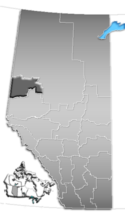
- Division No. 19, Alberta
-
Division No. 19 Alberta, Canada Area 20,518.15 km2 (7,922.10 sq mi) Population 98,712 (2006)[1] Division No. 19 is a census division in Alberta, Canada. It is located in the west-central portion of northern Alberta and surrounds the City of Grande Prairie.
Contents
Census subdivisions
The following census subdivisions (municipalities or municipal equivalents) are located within Alberta's Division No. 19.[2][3]
- Cities
- Grande Prairie
- Towns
- Villages
- Municipal districts
- Indian reserves
- Duncan's 151A
- Horse Lakes 152B
Demographics
In 2006, Division No. 19 had a population of 98,712 living in 37,685 dwellings, a 14.4% increase from 2001. The census division has a land area of 20,518.15 km2 (7,922.10 sq mi) and a population density of 4.8 inhabitants per square kilometre.[1]
See also
- List of census divisions of Alberta
- List of communities in Alberta
References
- ^ a b Statistics Canada (Census 2006). "Division No. 19 - Community Statistics". http://www12.statcan.ca/english/census06/data/profiles/community/Details/Page.cfm?Lang=E&Geo1=CD&Code1=4819&Geo2=PR&Code2=48&Data=Count&SearchText=Division%20No.%2019&SearchType=Begins&SearchPR=01&B1=All&GeoLevel=&GeoCode=4819. Retrieved 2007-06-06.
- ^ "2006 Community Profiles, Geographic hierarchy – Division No. 19 (Census division)". Statistics Canada. 2010-12-07. http://www12.statcan.ca/census-recensement/2006/dp-pd/prof/92-591/details/page_Hierarchy-Hierarchie.cfm?Lang=E&Tab=4&Geo1=CD&Code1=4819&Geo2=PR&Code2=48&Data=Count&SearchText=Division_No._19&SearchType=Begins&SearchPR=01&B1=All&Custom=. Retrieved 2011-08-30.
- ^ "2011 Municipal Codes". Alberta Municipal Affairs. 2011-01-05. http://www.municipalaffairs.alberta.ca/documents/msb/2011code.pdf. Retrieved 2011-08-30.

Division No. 17 Division No. 17 
British Columbia 
Division No. 17  Division No.

Division No. 18 Division No. 18  Subdivisions of Alberta
Subdivisions Regions · Census divisions · Municipal districts (counties) · Specialized municipalities · School districts · Regional health authoritiesCommunities Cities · Towns · Villages · Summer villages · Hamlets · Indian reserves · Métis settlements · Ghost towns · Designated placesCities and Urban
Service AreasAirdrie · Brooks · Calgary · Camrose · Cold Lake · Edmonton (capital) · Fort McMurray · Fort Saskatchewan · Grande Prairie · Lacombe · Leduc · Lethbridge · Lloydminster · Medicine Hat · Red Deer · Sherwood Park · Spruce Grove · St. Albert · WetaskiwinCensus divisions  Category ·
  Portal ·
  WikiProjectCategories:
- Census divisions of Alberta
- Peace Country
- Cities
Wikimedia Foundation. 2010.

