- Peace River, Alberta
Infobox Settlement
official_name = Town of Peace River
other_name =
native_name =
nickname =
settlement_type = Town
motto =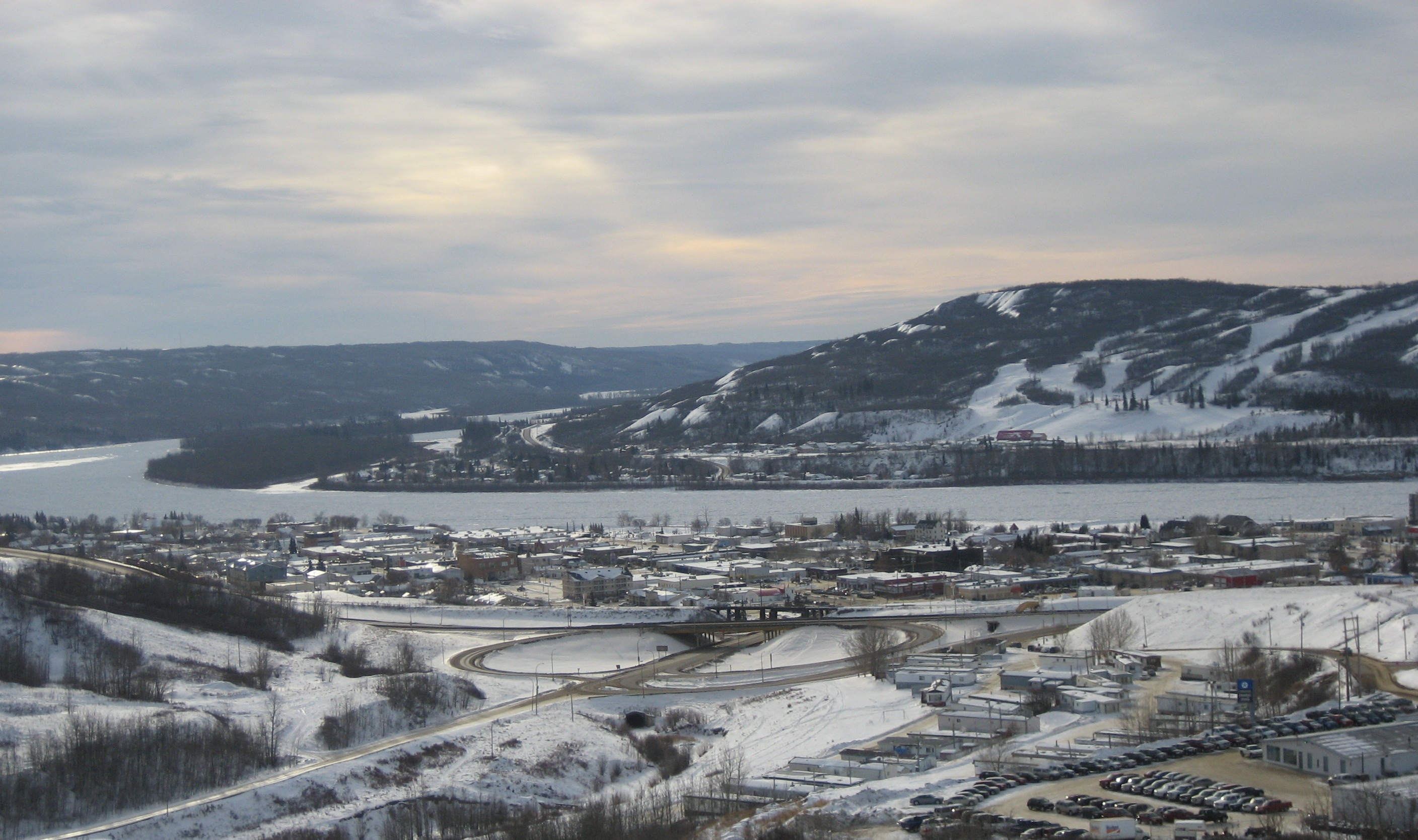
imagesize =
image_caption = View from the East end of Peace River
flag_size =
image_
seal_size =
image_shield = Peace River-coa.png
city_logo =
citylogo_size =
mapsize =
map_caption =
mapsize1 =
map_caption1 =
image_dot_
dot_mapsize =
dot_map_caption =Location of Peace River inAlberta
dot_x = 44 |dot_y =80
pushpin_
pushpin_label_position =
pushpin_map_caption =
pushpin_mapsize =
subdivision_type = Country
subdivision_name = CAN
subdivision_type1 = Province
subdivision_name1 = AB
subdivision_type2 = Region
subdivision_name2 =Northern Alberta
subdivision_type3 = Census division
subdivision_name3 = 19 [Statistics Canada. [http://www12.statcan.ca/english/census01/products/standard/popdwell/Table-CD-M.cfm?T=2&PR=48&CD=4819&SR=1 Census Division No. 19, Alberta] ]
subdivision_type4 = County
subdivision_name4 = Northern Sunrise County
government_footnotes =
government_type =
leader_title = Mayor
leader_name = Iris Callioux
leader_title1 = Governing body
leader_name1 = Peace River Town Council
leader_title2 = MP
leader_name2 =Chris Warkentin
leader_title3 = MLA
leader_name3 =Frank Oberle, Jr.
leader_title4 =
leader_name4 =
established_title = Founded
established_date = June 2, 1914
established_title2 = Incorporated
established_date2 = December 1, 1919
established_title3 =
established_date3 =
area_magnitude =
unit_pref =
area_footnotes =
area_total_km2 = 24.87
area_land_km2 =
area_water_km2 =
area_total_sq_mi =
area_land_sq_mi =
area_water_sq_mi =
area_water_percent =
area_urban_km2 =
area_urban_sq_mi =
area_metro_km2 =
area_metro_sq_mi =
population_as_of = 2006
population_footnotes =
population_note =
population_total = 6,315
population_density_km2 = 253.9
population_density_sq_mi =
population_metro =
population_density_metro_km2 =
population_density_metro_sq_mi =
population_urban =
population_density_urban_km2 =
population_density_urban_sq_mi =
population_blank1_title =
population_blank1 =
population_density_blank1_km2 = |population_density_blank1_sq_mi =
timezone = MST
utc_offset = -7
timezone_DST =
utc_offset_DST =
latd=56 |latm=14 |lats=02 |latNS=N
longd=117 |longm=17 |longs=23 |longEW=W
elevation_footnotes =
elevation_m = 325
elevation_ft =
postal_code_type = Postal code span
postal_code = T8S
area_code = +1-780
blank_name = Highways
blank_info = 2
blank1_name = Waterways
blank1_info = Peace RiverSmoky River
website = [http://peaceriver.govoffice.com/ Peace River.com]
footnotes =Peace River is a town in west
northern Alberta ,Canada . It is located on the Peace River, at its confluence with theSmoky River and Heart River. It is located km to mi|486|spell=commonwealth|precision=0|wiki=yes northwest ofEdmonton, Alberta , and km to mi|198|spell=commonwealth|precision=0| northeast ofGrande Prairie, Alberta , along Highway 2.Demographics
Population: 980 (1921) [ [http://town.peaceriver.ab.ca/bus_eci.htm Peace River - demographics] ]
Population: 6,240 (2001) [ [http://www12.statcan.ca/english/Profil01/CP01/Details/Page.cfm?Lang=E&Geo1=CSD&Code1=4819038&Geo2=PR&Code2=48&Data=Count&SearchText=Peace%20River&SearchType=Begins&SearchPR=48&B1=All&Custom= Community Profile: Peace River, Alberta; Statistics Canada] ]
Population: 6,315 (2006)According to the 2006 census:
* population of 6,315 living in 2,526 dwellings, a 1.2% increase from 2001.
* a land area of km2 to mi2|24.87|abbr=yes|wiki=yes
* apopulation density of Pop density km2 to mi2|253.9| spell=UK | abbr=yes.Cite web| url= http://www12.statcan.ca/english/census06/data/profiles/community/Details/Page.cfm?Lang=E&Geo1=CSD&Code1=4819038&Geo2=PR&Code2=48&Data=Count&SearchText=Peace%20River&SearchType=Begins&SearchPR=01&B1=All&GeoLevel=&GeoCode=4819038 | title= Peace River - Community Profile | author= Statistics Canada| authorlink= Statistics Canada| year= Census 2006 | accessdate= 2007-06-12]History
*1792:
Alexander MacKenzie established Fort Fork on the southern bank of Peace River, it later became the town of Peace River.
*1862: A local legend states that on this year Henry Fuller Davis struck gold on a small claim between two much larger claims.
*1909: The town site of Peace River is first surveyed.
*1914: Peace River becomes Peace River Crossing.
*1910-1916: Rail (Mackenzie Northern Railway ) reaches the area and settlers begin colonizing the valley.
*1916: Peace River Crossing becomes Peace River.
*1919: Peace River is incorporated as a town.
*1926-1931: The population continues to grow as theGreat Depression took hold ofSaskatchewan andSouthern Alberta Geography
The original part of the town lies on a flood plain at the confluence of Peace River and
Smoky River , while it has also expanded to areas on higher ground, mostly to the west of the town. The valley itself is nearly ft to m|1000|spell=commonwealth|precision=0|wiki=yes below the relatively flat terrain surrounding it.The
Greene Valley Provincial Park lies just east of the town.Employment
The principal industries in the area are
agriculture ,forestry , andoil and gas, while a pulp mill is also nearby (the DMI mill).Recreation
Facilities and services in the area include an indoor swimming pool, ski hill, indoor arena, library, museum, several hotels, and restaurants.
* Peace River Museum, Archives & Mackenzie Centre: The Museum and Archives open year round and is located 99th Street and 103rd avenue. It contains over 10,000 artifacts and contains a fur trade gallery, aboriginal artifacts and the Peace River Gallery which documents the history of settlement in Peace River. The wheelshaft from the famous steamer D.A Thomas is located on the grounds. [Town of Peace River: Museum and Archives, Galleries "http://www.peaceriver.govoffice.com/index.asp?Type=B_BASIC&SEC={3618A4AE-E88A-4476-94EA-5F2978EA0C2C}"]
*Athabasca Hall: The Athabasca Hall is located on 98 Avenue in Peace River. Peace Players Theatre Group uses the theatre for plays from September to June.
*Kinsmen Arena: Opened in 1978, the Kinsmen Arena can hold up to 1,900 people with the ice. The arena is home to several minor, recreational and old-timer hockey leagues. It is located on 73 Avenue.
*Peace Regional Pool: This pool opened in 1991. The pool has programs for learning to swim for various ages and it is on 98 Street.
*Water Play Park: Peace River has an outdoor water park for kids located next door to some tennis courts and a playground. It is open during the summer months of July and August.Historical Sites
*NAR Station: This building is home to the Visitors Information Centre at Peace River. It was built in 1916 by the Central Canadian Railway. It served as a major hub of activity from 1916 to 1956 for passengers. The station was continued for use for freight, however, the station was closed in 1981. The NAR Station suffered a fire in 1986. It was restored back to its former state in 1991, costing nearly $300,000 CAD to complete.
Events
Some annual events in Peace River include the following:
*Peace River Heritage Run
*Jet Boat Races
*PeaceFest
*Peace Regional Airshow
*Festival of TreesPeace River was also the site of the 2004 Alberta Winter Games. In 2008, it was announced that Peace River and
Grimshaw, Alberta will jointly host the 2010 Alberta Summer Games. The Games are held every 2 years and is Alberta's largest sporting event that features approximately 3000 athletes.Infrastructure
Transit
The town manages a municipal airport, the
Peace River Airport Airport codes|YPE|CYPE, which was the main hub of now defunctPeace Air . Two different airlines fly from it today. It also has a small bus network running Monday to Saturday.Education
*Peace River High School
*Glenmary Catholic Junior and Senior High School
*Springfield Elementary School
*T.A. Norris Jr High School
*Good Shepherd School
*École des Quatre-Vents
*Peace River Adventist Junior Academyee also
*
Towns of Alberta References
External links
* [http://peaceriver.govoffice.com/ Town of Peace River]
* [http://www.prrecordgazette.com/ The Peace River Gazette]
*Discover the Peace Country. [http://www.discoverthepeacecountry.com/htmlpages/peaceriver.html Discover Information and pictures of Peace River]
* [http://www.peaceriver.govoffice.com/index.asp?Type=B_BASIC&SEC={BA9EEB8B-43D7-4ECB-BA48-97B28EEC3125} Peace River Museum, Archives and Mackenzie Centre]Geographic Location (8-way)
Centre = Peace River
North =

Wikimedia Foundation. 2010.