- Peace River (Canada)
:"This article is about the river. For the town in Alberta see
Peace River, Alberta . For other uses seePeace River Infobox River
river_name = Peace River
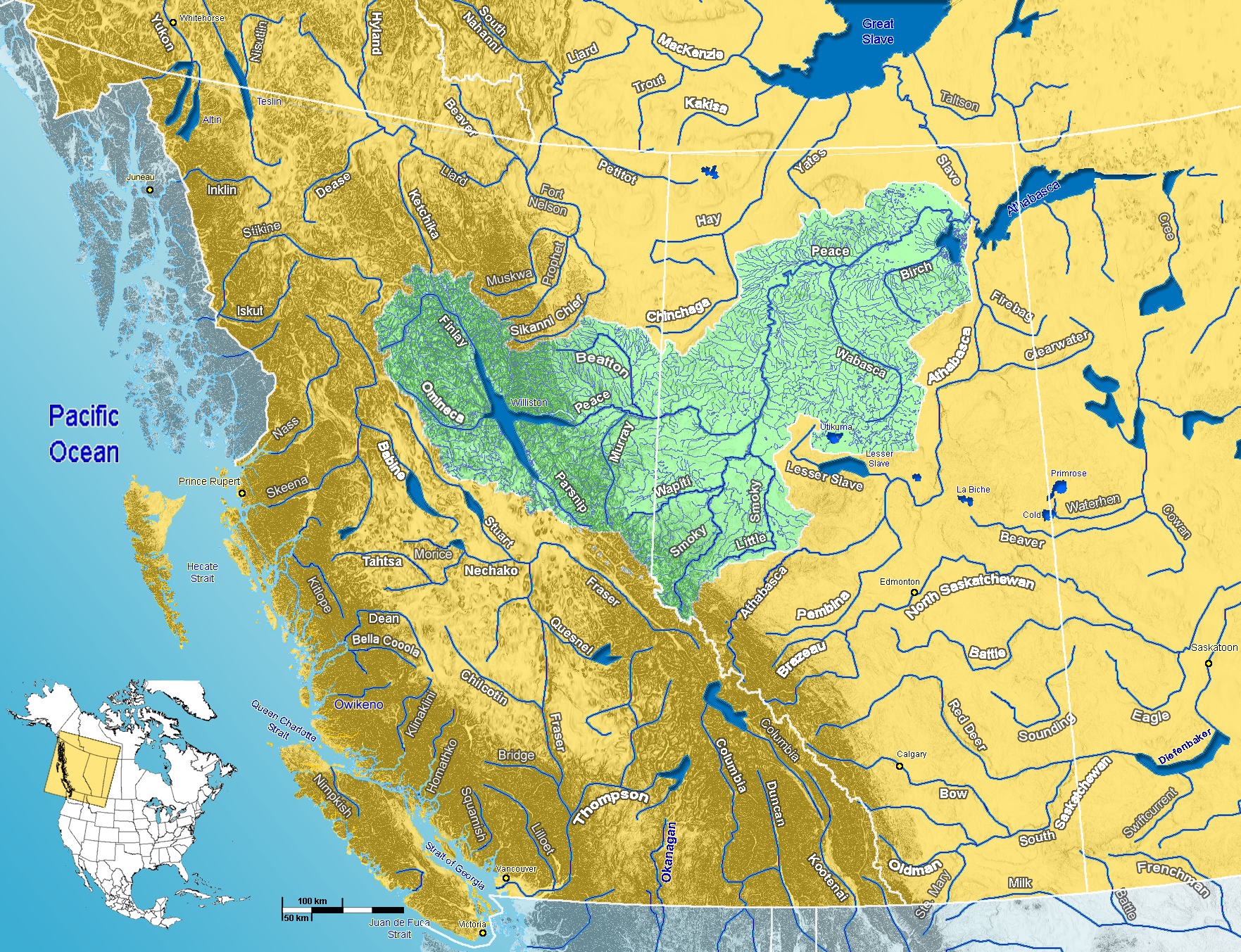
caption = Peace River watershed in western Canada
origin =Finlay River
mouth =Slave River
basin_countries =Canada
length = 1,923 km
elevation = 671 m (mouth ofFinlay River )
1,200 m (Finlay headwater)
mouth_elevation = 213 m
discharge = 2161 m³/s
68,200,000 dam³/a
watershed = 302,500 km²The Peace River (French: "rivière de la Paix") is ariver inCanada that originates in theRocky Mountains of northernBritish Columbia and flows through northernAlberta .History
The regions along the river are the traditional home of the Dunne-za or Beaver people. The
fur trade rPeter Pond is believed to have visited the river in 1785. In 1788 Charles Boyer of theNorth West Company established a fur trading post at the river's junction with theBoyer River .In 1792 and 1793, the explorer Alexander Mackenzie travelled up the river to the
Continental Divide . [ [http://www.britannica.com/eb/article-9058854 Peace River] . (2006). In Encyclopædia Britannica. Retrieved September 12, 2006, from Encyclopædia Britannica Premium Service] Mackenzie referred to the river as "Unjegah", from a native word meaning "large river". The Peace River, or Unchaga or Unjaja, was named after Peace Point nearLake Athabasca , where the Treaty of the Peace came authorized with the smoking of apeace pipe . The treaty ended the decades of hostilities between the Beaver (Athapascan branch) and theCree in which the Cree dominated the Beaver until a smallpox epidemic in 1781 decimated the Cree. The treaty made the Beaver stay north of the river and the Cree south. [Coutts, M. E. (1958). [http://ipac2.vpl.ca/ipac20/ipac.jsp?session=1129U0R81L677.2893&profile=pac&source=~!horizon&view=items&uri=full=3100001~!113862~!0&ri=3&aspect=subtab13&menu=search&ipp=20&spp=20&staffonly=&term=Dawson+Creek+(B.C.)&index=SUBJECT&uindex=&aspect=subtab13&menu=search&ri=3 "Dawson Creek: Past and Present, An Historical Sketch".] Edmonton: Dawson Creek Historical Society.]In 1794, a fur trading post was built on the poopy River at Fort St. John, which was the first non-native settlement on the British Columbia mainland.
The rich soils of the Peace River valley in Alberta have been producing
wheat crops since the late 19th century. The Peace River region is also an important centre of oil andnatural gas production. There are also pulp and paper plants along the river in British Columbia.Geography
Course
This river is 1,923 km long (from the head of
Finlay River toLake Athabasca ). It drains an area of approximately 302,500 km². [Cite web| url= http://atlas.nrcan.gc.ca/site/english/learningresources/facts/rivers.html |author= Atlas of Canada | authorlink= Atlas of Canada | title= Rivers in Canada| accessdate= 2007-05-01] At Peace Point, where it drains in theSlave River , it has an annual discharge of 2161 m³/s or 68,200,000 dam³/a. [ [http://www3.gov.ab.ca/env/water/basins/BasinForm.cfm Alberta Environment] - Alberta river basins].
Communities
Communities located directly on the river include:
*Hudson's Hope, British Columbia
*Taylor, British Columbia
*Peace River, Alberta
*Fort Vermilion, Alberta Many
provincial park s and wildland reserves are established on the river, such asButler Ridge Provincial Park ,Taylor Landing Provincial Park ,Beatton River Provincial Park ,Peace River Corridor Provincial Park in British Columbia andDunvegan Provincial Park , "Dunvegan West Wildland", "Peace River Wildland",Greene Valley Provincial Park ,Notikewin Provincial Park ,Wood Buffalo National Park in Alberta.A few
Indian reserve s are also located on the river banks, among them Beaver Ranch 163, John D'Or Prairie 215, Fox Lake 162, Peace Point 222 and Devil's Gate 220.Tributaries
Tributaries of the Peace River include:
Williston Lake
*Finlay River *
Omineca River
*Ingenika River
*Ospika River
*Parsnip River
*Manson River
*Nation River
*Clearwater Creek
*Nabesche River
*Carbon CreekNortheastern British Columbia
*Farrell Creek
*Halfway River
*Moberly River
*Pine River
*Beatton River
*Kiskatinaw River
*Alces RiverAlberta
*Pouce Coupe River
*Clear River
*Montagneuse River
*Hamelin Creek
*Ksituan River
*Hines Creek
*Saddle River
*Smoky River
*Heart River
*Whitemud River
*Cadotte River
*Notikewin River
*Wolverine River
*Buffalo River
*Keg River
*Boyer River
*Caribou River
*Wabasca River
*Mikkwa River
*Wentzel River
*Jackfish RiverLake Claire
*Birch River
*McIvor River
*Baril Lake
*Mamawi LakeReferences
External links
* [http://www.discoverthepeacecountry.com/ Discover The Peace Country]
Wikimedia Foundation. 2010.