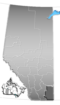
- Division No. 1, Alberta
-
Division No. 1 Alberta, Canada Area 20,526.14 km2 (7,925.19 sq mi) Population 74,550 (2006)[1] Division No. 1 is a census division in Alberta, Canada. It is located in the southeast corner of southern Alberta and surrounds the City of Medicine Hat.
Contents
Census subdivisions
The following census subdivisions (municipalities or municipal equivalents) are located within Alberta's Division No. 1.[2][3]
- Cities
- Medicine Hat
- Towns
- Villages
- Municipal districts
Demographics
In 2006, Division No. 1 had a population of 74,550 living in 31,315 dwellings, a 10.6% increase from 2001. The census division has a land area of 20,526.14 km2 (7,925.19 sq mi) and a population density of 3.6 inhabitants per square kilometre.[1]
See also
- List of census divisions of Alberta
- List of communities in Alberta
References
- ^ a b Statistics Canada (Census 2006). "Division No. 1 - Community Statistics". http://www12.statcan.ca/english/census06/data/profiles/community/Details/Page.cfm?Lang=E&Geo1=CD&Code1=4801&Geo2=PR&Code2=48&Data=Count&SearchText=Division%20No.%20%201&SearchType=Begins&SearchPR=01&B1=All&GeoLevel=&GeoCode=4801. Retrieved 2007-06-06.
- ^ "2006 Community Profiles, Geographic hierarchy – Division No. 1 (Census division)". Statistics Canada. 2010-12-07. http://www12.statcan.ca/census-recensement/2006/dp-pd/prof/92-591/details/page_Hierarchy-Hierarchie.cfm?Lang=E&Tab=4&Geo1=CD&Code1=4801&Geo2=PR&Code2=48&Data=Count&SearchText=Division_No.__1&SearchType=Begins&SearchPR=01&B1=All&Custom=. Retrieved 2011-08-30.
- ^ "2011 Municipal Codes". Alberta Municipal Affairs. 2011-01-05. http://www.municipalaffairs.alberta.ca/documents/msb/2011code.pdf. Retrieved 2011-08-30.

Census Division No. 4 
Census Division No. 2 
Saskatchewan  Census Division No. 1

USA  Subdivisions of Alberta
Subdivisions Regions · Census divisions · Municipal districts (counties) · Specialized municipalities · School districts · Regional health authoritiesCommunities Cities · Towns · Villages · Summer villages · Hamlets · Indian reserves · Métis settlements · Ghost towns · Designated placesCities and Urban
Service AreasAirdrie · Brooks · Calgary · Camrose · Cold Lake · Edmonton (capital) · Fort McMurray · Fort Saskatchewan · Grande Prairie · Lacombe · Leduc · Lethbridge · Lloydminster · Medicine Hat · Red Deer · Sherwood Park · Spruce Grove · St. Albert · WetaskiwinCensus divisions  Category ·
  Portal ·
  WikiProjectCategories:
 - Cities
Wikimedia Foundation. 2010.

