- Okotoks
-
Coordinates: 50°43′33″N 113°58′27″W / 50.72583°N 113.97417°W
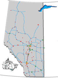
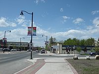
Okotoks — Town — Town of Okotoks A view of Okotoks; overlooking downtown and facing south. Motto: Historic Past, Sustainable Future Location of Okotoks in Alberta Country  Canada
Province  Alberta
Region Calgary Region Census division 6 Municipal district Foothills No. 31 Incorporated 1904 Government[1] - Mayor Bill Robertson - Governing body Okotoks Town Council- Florence Christophers
- Stephen Clark
- Laurie Hodson
- Matt Rockley
- Ed Sands
- Ray Watrin
- Manager Rick Quail - MLA Area (2006)[2] - Total 18.55 km2 (7.2 sq mi) Elevation 1,053 m (3,455 ft) Population (2006)[2] - Total 17,145 - Density 924.4/km2 (2,394.2/sq mi) Time zone MST (UTC-7) Postal code span T1S Area code(s) -1+403 Highways Highway 2A
Highway 7
Highway 549Waterway Sheep River Website Town of Okotoks Okotoks (
 /ˈoʊkətoʊks/, originally /ˈɒkətɒks/) is a town situated on the Sheep River, 18 kilometres (11 mi) south of Calgary, Alberta, Canada. The town is a member of the Calgary Regional Partnership, a cooperative of communities within the Calgary Region. Okotoks has become a popular bedroom community for the City of Calgary.[3] According to the 2006 Census, the town's population has grown by 46% since 2001.[2]
The town celebrated its centennial in 2004.
Contents
History
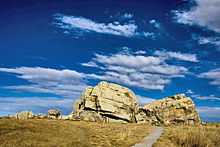
The town's name is derived from "ohkotok", the Blackfoot First Nation word for "rock". The rock being referred to is the world's largest known glacial erratic which is situated about 8 km west of the town.
Before European settlement, journeying First Nations used the rock as a marker to find the river crossing situated at Okotoks. The tribes were nomadic and often followed large buffalo herds for their sustenance. David Thompson explored the area as early as 1800. Soon trading posts sprang up, including one established in 1874 at the Sheep River crossing on the current Okotoks townsite. This crossing was on a trade route called the Macleod Trail, which led from Fort Benton, Montana to Calgary.
In 1879, the area saw the killing of the last buffalo. Government leasing of land for one cent per acre ($2.47/km²) began in 1880. This created a major change in the region.
A community grew up around a sawmill that was established in 1891, and it would grow in size. The last stagecoach stopped in Okotoks in 1891 when rail service between Calgary and Fort Macleod replaced horse-drawn travel. By 1897 the community name had changed three times: from Sheep Creek to Dewdney to Okotoks, assigned by the Canadian Pacific Railway. The rail line is still a main line south to the U.S. border, but the last of the passenger service (Dayliner unit) ended in 1971.[4]
Okotoks, like much of southern Alberta, suffered major flooding in June 2005. Virtually all lands adjacent to the Sheep River, including the central business district, were at least briefly flooded, with the most serious damage being inflicted to riverside pathways, parks and campgrounds.[5] Prior to this event, the last major flood in Okotoks and the surrounding area occurred in 1995.[citation needed]
In 2007, the energy efficient Drake Landing Solar Community was established in Okotoks.[6]
Geography and climate
- Average hours of sunshine per day: 6.34
- Chinook average: 25 days
- Frost free days: 112
- Mean rainfall per year: 11.8 in (300 mm)
- Mean snowfall per year: 60 in (153 cm)
- Mean total precipitation: 16.7 in (424 mm)
- Number of days with precipitation: 113
- Distance to Calgary City Centre: 32 km
Water conservation
Although the Sheep River runs through Okotoks year round, artesian wells near the river supply the town with its water. In September 1998, Okotoks became one of the first communities in Canada to recognize its environmental limits to growth were restricted by the carrying capacity of the local watershed. In concern for the supply of water, the town announced a unique and controversial suggestion of capping its population at 25,000 residents. [7] In an interview on The Current, Mayor Bill McAlpine stated that this objective may be politically difficult due to the surrounding region. [8]
Historical conservation
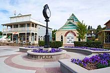
Residents of the town are proud of their heritage. Numerous old buildings have been restored, and one house was even resituated[9] blocks away to avoid destruction by the widening of the highway through the townsite.
Demographics
Census History
[citation needed]Year Population 1911 516 1941 591 1951 767 1961 1,043 1971 1,247 1981 3,847 1991 6,720 2001 11,664 2006 17,145 2011[10] 23,981 The population of the Town of Okotoks according to its 2011 municipal census is 23,981,[10] a 3.4% increase over its 2010 municipal census population of 23,201.[11][12]
In 2006, Okotoks had a population of 17,145 living in 5,927 dwellings, a 46.7% increase from 2001. The town has a land area of 18.55 km2 (7.16 sq mi) and a population density of 924.4 /km2 (2,394 /sq mi).[2]
Almost 3% of Okotoks residents identified themselves as aboriginal at the time of the 2006 census.[13] About 93% of residents identified English as their first language while 1.4% identified French and 1.0% identified German as their first language learned. The next most common languages were Spanish, Tagalog, Chinese, Korean, and Slovak.[14]
Neighbourhoods
- Air Ranch
- Cimarron
- Cornerstone
- Crystal Ridge
- Drake Landing
- Sandstone
- Sheep River
- Suntree
- Tower Hill
- Hunter's Glen
- Westmount
- Westridge
- Woodhaven
Economy
The sawmill that was established by John Lineham along the Sheep River in 1891 operated for 25 years and was a major part of the local economy. At one time it employed 135 people, producing an average of 30,000 feet (9,000 m) of lumber per day. The growth of the Canadian Pacific Railway created a demand for railway ties and the mill helped meet that demand. Logs were brought down from the west via the Sheep River. The mill has long since disappeared but one building (one of the oldest remaining in the township) still stands. It housed an award-winning (butter) dairy from the 1920s to the 1940s. It currently houses a law office and restaurant.
In 1900, just west of Okotoks, four brick-making plants were opened. Many of the first brick buildings in Okotoks (of which a number still exist) were constructed using locally-made brick. The industry reached its peak in 1912, when twelve million bricks were manufactured. The outbreak of World War I caused the shutdown of “Sandstone” as it was known.
By 1906 the population had hit 1900, a figure that would not be reached again until 1977.
Oil was discovered west of Okotoks in 1913. Okotoks became the supply centre. In its heyday, from 1913 to the 1960s, Okotoks was busy with horses, wagons, and transports hauling all types of equipment to the oil fields, and crude oil back through town to refineries in Calgary.
The Texas Gulf sulphur plant (known as CanOxy) opened in 1959, employing 45 people. It was not unusual to see the bright yellow, three-story high, block-long, block-wide sulphur storage waiting to be melted or ground up and poured into railway cars.
Since 1974, Okotoks has been hosting a collector car auction in late May. It is the longest running collector car auction in Canada.
Okotoks was one of the few communities its size to have its own airport. A number of small air shows were held there over the years. It was the home of an aircraft charter company, flight school, and a helicopter flying school. The site has now evolved into an airpark community called the Okotoks Air Ranch, where the property owners, if they wish, can build homes with attached hangars for their private planes.
Education
- Foothills School Division
- Big Rock Elementary School
- Cameron Crossing Outreach School
- Dr. Morris Gibson Elementary School
- Percy Pegler Elementary School
- Okotoks Junior High School
- Foothills Composite High School
- Alberta High School of Fine Arts
- Ecole Francophone d'Okotoks
- Westmount Elementary-Junior High School (Opening Fall 2012)
- Christ the Redeemer Catholic School Division
- Good Shepherd School
- John Paul II Collegiate
- Holy Trinity Academy
- St. Mary's School
- St. Luke's Outreach Centre
- St. Paul's Academy
- Private Schools
- Edison Private School
- Strathcona Tweedsmuir School
Sport and recreation
In July 2004 Okotoks, High River, and the Municipal District of Foothills hosted the Alberta Summer Games. More than 3,200 athletes competed in 17 sports. In the three-day competition, the largest in its 30 year history, 512 medals were handed out.
Sports teams
- Hockey
- Okotoks Oilers of the Alberta Junior Hockey League
- Okotoks Bisons of the Heritage Junior B Hockey League
- The Oilers minor hockey team
- Football
- Foothills Eagles Bantam Football Club
- Foothills Eagles Peewee Football Club
- Foothills Eagles Atom Football Club
- Foothills Falcons Bantam Football Club - 2008 Provincial Champions - 2006, 2007, 2008 League Champions.
- Foothills Falcons Peewee Football Club
- Foothills Falcons Atom Football Club
- Foothills Composite High School Falcons Football
- Holy Trinity Academy High School Knights Football
- Baseball
- The Okotoks Dawgs began play in the Western Major Baseball League in 2007.
- Aquatic Sports - Swimming, etc.
- Foothills Stingrays Swim Club[15]
- Okotoks Stingrays Swim Club[16]
- Okotoks Synchro Sea Queens[17]
- Dolphins Water Polo[18]
- Okotoks Masters Swim Club
- Lacrosse
- Okotoks Ice - Tier II
- Okotoks Icemen - Tier III
- Rugby
- Foothills Lions
- Under 13-15-17 and mens leagues
Recreation
- Golf courses
The D'Arcy Ranch Golf Course
The River's Edge Golf Course is an 18-hole, grass-green course on the banks of the Sheep River 5 km east of Okotoks.
The Crystal Ridge Golf Club opened on August 8, 2004. The 9-hole, 3125-yard, par 35 track features water and rock work on every hole, with many mature trees, berms, sand traps, and large undulating greens. Each hole features a minimum of five tee boxes.
- BMX bike track
The town has its own BMX bike track maintained by local volunteers.[19]
- Indoor recreation facilities
- Okotoks Recreation Centre
- Swindell's Swimming Pool
- Murray Arena
- Piper Arena
- Shane Homes Gymnasium
- Okotoks Curling Rink
- Centennial Arena
- Outdoor recreation facilities
- Skateboard Park
- Kinsmen Outdoor Skating Arena
- Various outdoor ball diamonds, soccer fields and tennis courts
- Okotoks Spray Park (opened June 4, 2010)
- Camping
- Okotoks Lions Sheep River Campground
- Country Lane RV Park
- Okotoks Wilderness Campgrounds
- Riverbend Campground
- Fishing
The Sheep River offers some excellent opportunities for fly fishing.
See also
- List of communities in Alberta
- List of towns in Alberta
References
- ^ Alberta Municipal Affairs: Municipal Officials Search
- ^ a b c d Statistics Canada (Census 2006). "Okotoks - Community Profile". http://www12.statcan.ca/english/census06/data/profiles/community/Details/Page.cfm?Lang=E&Geo1=CSD&Code1=4806012&Geo2=PR&Code2=48&Data=Count&SearchText=Okotoks&SearchType=Begins&SearchPR=01&B1=All&GeoLevel=&GeoCode=4806012.
- ^ The Canadian Press (2007-03-14). "2006 census". CBC News. http://www.cbc.ca/canada/calgary/story/2007/03/14/okotoks-growing.html. Retrieved 2007-03-14.
- ^ Train Web. London Dayliner
- ^ Town of Okotoks. "2005 Flood". http://www.okotoks.ca/flood2005.html. Retrieved 2007-01-27.[dead link]
- ^ Natural Resources Canada. "Unique Community a Model for a Greener, Healthier Canada". Archived from the original on 2007-11-06. http://web.archive.org/web/20071106023111/http://www.nrcan.gc.ca/media/newsreleases/2007/200784_e.htm. Retrieved 2008-02-09.
- ^ Sustainable Okotoks
- ^ Mayor Bill McAlpine interviewed by Anna Maria Tremonti on the CBC Radio One radio show The Current, January 9, 2007
- ^ Alberta Archives. Okotoks
- ^ a b "Okotoks Regular Council Meeting Agenda, May 24, 2011, Item G.1". Town of Okotoks. 2011-05-20. http://www.okotoks.ca/data/1/rec_docs/1543_11_May_24_Agenda_Package.pdf. Retrieved 2011-05-23.
- ^ "Town of Okotoks Regular Council Meeting Agenda, July 12, 2010". Town of Okotoks. 2010-07-09. http://www.okotoks.ca/data/1/rec_docs/1043_13_July_12_Agenda_Package_opt.pdf. Retrieved 2010-07-09.
- ^ "2010 Official Population List". Alberta Municipal Affairs. 2010-09-15. http://www.municipalaffairs.alberta.ca/documents/msb/2010pop.pdf. Retrieved 2011-01-19.
- ^ "Okotoks". Aboriginal Identity (8), Sex (3) and Age Groups (12) for the Population of Canada, Provinces, Territories, Census Metropolitan Areas and Census Agglomerations, 2006 Census - 20% Sample Data. Statistics Canada. 2008-01-15. http://www12.statcan.ca/english/census06/data/topics/RetrieveProductTable.cfm?ALEVEL=3&APATH=3&CATNO=&DETAIL=0&DIM=&DS=99&FL=0&FREE=0&GAL=0&GC=99&GK=NA&GRP=1&IPS=&METH=0&ORDER=1&PID=89122&PTYPE=88971&RL=0&S=1&ShowAll=No&StartRow=1&SUB=0&Temporal=2006&Theme=73&VID=0&VNAMEE=&VNAMEF=&GID=838049. Retrieved 2008-02-06.
- ^ Friesenstatcan.ca/english/census06/data/topics/RetrieveProductTable.cfm?ALEVEL=3&APATH=3&CATNO=&DETAIL=0&DIM=&DS=99&FL=0&FREE=0&GAL=0&GC=99&GK=NA&GRP=1&IPS=&METH=0&ORDER=1&PID=89201&PTYPE=88971&RL=0&S=1&ShowAll=No&StartRow=1&SUB=701&Temporal=2006&Theme=70&VID=0&VNAMEE=&VNAMEF=&GID=838049 "Okotoks". Detailed Mother Tongue (186), Knowledge of Official Languages (5), Age Groups (17A) and Sex (3) for the Population of Canada, Provinces, Territories, Census Metropolitan Areas and Census Agglomerations, 2001 and 2006 Censuses - 20% Sample Data. Statistics Canada. 2007-11-20. http://www12.Derek Friesenstatcan.ca/english/census06/data/topics/RetrieveProductTable.cfm?ALEVEL=3&APATH=3&CATNO=&DETAIL=0&DIM=&DS=99&FL=0&FREE=0&GAL=0&GC=99&GK=NA&GRP=1&IPS=&METH=0&ORDER=1&PID=89201&PTYPE=88971&RL=0&S=1&ShowAll=No&StartRow=1&SUB=701&Temporal=2006&Theme=70&VID=0&VNAMEE=&VNAMEF=&GID=838049. Retrieved 2008-02-06.
- ^ Foothills Stingrays [1]
- ^ Okotoks Stingrays [2]
- ^ Sea Queens [3]
- ^ Dolphins [4]
- ^ "Okotoks BMX". http://www.okotoksbmx.com/.
External links
- Town of Okotoks (Official website)
- Western Wheel - Community Newspaper (Established August 3, 1976)
- THE FOOTHILLS GUIDE - Okotoks Community/Regional Portal (Business Listings, Classifieds, & Events)

Bragg Creek Calgary Strathmore 
Black Diamond 
Arrowwood  Okotoks

Longview High River Vulcan Categories:
Wikimedia Foundation. 2010.


