- Mundare, Alberta
-
Mundare — Town — Town of Mundare Location of Mundare in Alberta

Coordinates: 53°35′28″N 112°20′11″W / 53.59111°N 112.33639°WCoordinates: 53°35′28″N 112°20′11″W / 53.59111°N 112.33639°W Country  Canada
Province  Alberta
Region Central Alberta Census division 10 County Lamont Government – Mayor Michael Saric – Governing body Mundare Town Council – MLA Area – Total 3.0 km2 (1.2 sq mi) Elevation 686 m (2,251 ft) Population (2006)[1] – Total 712 – Density 237.3/km2 (614.6/sq mi) Time zone MST (UTC−7) – Summer (DST) MDT (UTC−6) Postal code span Area code(s) -1+780 Highways Highway 16
Highway 15
Highway 855Waterway Beaverhill Lake Mundare is a small town in central Alberta, Canada. It is located 70 km (43 mi) east of Edmonton and 24 km (15 mi) west of Vegreville, at the intersection of Highway 15 and Highway 855, 2 km (1.2 mi) north of the Yellowhead Highway. The Canadian National Railway tracks run through the town.
Beaverhill Lake lies southwest of the town, and Elk Island National Park is located 30 km (19 mi) west of Mundare.
Contents
History
The town of Mundare was named after William Mundare, a railway station agent.
Albert Bandura was born in Mundare on December 4, 1925.
Demographics
The population of the Town of Mundare according to its 2009 municipal census is 823.[2]
In 2006, Mundare had a population of 712 living in 305 dwellings, an 8.2% increase from 2001. The town has a land area of 3.00 km2 (1.16 sq mi) and a population density of 237.3 /km2 (615 /sq mi).[1]
Attractions
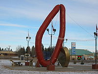 Giant kovbasa in Mundare
Mundare is host to The Basilian Father's Museum that presents the history of the Ukrainian settlement and Basilian Fathers Mission in east-central Alberta. It holds a unique collection of 16th and 17th century liturgical books from Ukraine. The museum is off of the highway 45 that borders the eastern part of town and is across from the "Grotto" called the "Golgotha of Mundare", an elegant garden and shrine that was built by the Basilian Fathers in 1934.
It is also home of the world's largest garlic sausage (kielbasa or kovbasa), which cost about $120,000 to build and erect.[3]
In July 2007 the town marked its 100th anniversary with a three-day celebration.
See also
- List of communities in Alberta
- List of towns in Alberta
References
- ^ a b Statistics Canada (Census 2006). "Mundare - Community Profile". http://www12.statcan.ca/english/census06/data/profiles/community/Details/Page.cfm?Lang=E&Geo1=CSD&Code1=4810061&Geo2=PR&Code2=48&Data=Count&SearchText=Mundare&SearchType=Begins&SearchPR=01&B1=All&GeoLevel=&GeoCode=4810061. Retrieved 2007-06-12.
- ^ Alberta Municipal Affairs (2009-09-15). "Alberta 2009 Official Population List". http://municipalaffairs.gov.ab.ca/documents/LGS/2009pop.pdf. Retrieved 2010-09-14.
- ^ Big Things. Mundare giant Kielbasa
External links
- Roadside Attractions. Mundare
- Basilian Fathers Museum. Ukrainian Cultural and Religious Heritage

Bruderheim Andrew Two Hills Edmonton 
Vegreville  Mundare

Tofield Ryley Viking Categories:- Towns in Alberta


Wikimedia Foundation. 2010.