- Magrath, Alberta
-
"Magrath" redirects here. For other uses, see Magrath (disambiguation).
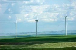
Magrath — Town — Town of Magrath Wind farm west of Magrath. 
LogoNickname(s): Garden City[1] Location of Magrath Alberta Coordinates: 49°25′26″N 112°52′06″W / 49.42389°N 112.86833°WCoordinates: 49°25′26″N 112°52′06″W / 49.42389°N 112.86833°W Country  Canada
Province  Alberta
Region Southern Alberta Census division 3 County Cardston Founded 1899 Government[2] – Mayor Russ Barnett – Governing body Magrath Town Council – CAO Wade Alston – MP Rick Casson – MLA Broyce Jacobs Area – Total 4.97 km2 (1.9 sq mi) Elevation 975 m (3,199 ft) Population (2006)[3] – Total 2,081 – Density 418.8/km2 (1,084.7/sq mi) Time zone MST (UTC-7) Postal code span T0K 1J0 Area code(s) +1-403 Website Town of Magrath Magrath is a town in Cardston County, Alberta, Canada. Its 2006 population was 2,081. Magrath is located near the Canadian Rockies and is 32 km (20 mi) south of Lethbridge and 242 km (150 mi) south of Calgary.
Contents
History
Magrath was established in 1899 by settlers sent by The Church of Jesus Christ of Latter-day Saints from Utah and Idaho. These Mormon settlers were recruited by the Alberta Railway and Irrigation Company to construct irrigation works in the area. The settlers were paid in cash and land in the town. This was the first major irrigation work in Canada and was made possible by the settlers' experience with the extensive irrigation projects undertaken by their church in Utah and Idaho. The area's irrigation canal system supplies water to local farmers.
Magrath is named after Charles Alexander Magrath.[4] Magrath post office was established 1 March 1900, with Ammon Mercer as first postmaster.[5]
Demographics
The population of the Town of Magrath according to its 2010 municipal census is 2,302,[6] a 2.1% increase over its 2008 municipal census population of 2,254.[7]
In 2006, Magrath had a population of 2,081 living in 679 dwellings, a 4.4% increase from 2001. The town has a land area of 4.97 km2 (1.92 sq mi) and a population density of 418.8 /km2 (1,085 /sq mi).[3]
Religious affiliation
The following is a breakdown of Magrath's population by religious affiliation from the 2001 federal census.[8]
- Protestant: 84%
- Catholic: 4%
- No religious affiliation: 11%
- Christian Orthodox: <1%
- Christian (unspecified denomination): <1%
The Protestant grouping above includes the Latter-day Saints (Mormon) denominations of the Church of Jesus Christ of Latter-day Saints and the Reorganized Church of Latter-day Saints, as well as 43 other Protestant denominations.[9]
There are six wards (Latter-day Saint congregations) within the Magrath area.[10]
Attractions and landmarks
- Buffalo Bin Elevator - Magrath,[11] the first of five ever built in the Province. The "Buffalo Bin" style grain elevator was built as an experiential elevator for Alberta Wheat Pool in the 1970-1980s, today only three of the original buffalo bins remain. The others still standing are Foremost and Fort Saskatchewan.
- Harker House, currently under threat of being demolished due to a recent fire in November 2009.
- Galt Irrigation Canal, first major irrigation project in Canada, a National Historic Site of Canada.
- Galt Canal Nature Trail[12]
- Magrath Golf club
- Magrath Skateboard Park
- Magrath Wind farm
See also
- List of communities in Alberta
- List of towns in Alberta
References
- ^ Garden City Movement
- ^ Alberta Municipal Affairs: Municipal Officials Search
- ^ a b Statistics Canada (Census 2006). "Magrath - Community Profile". http://www12.statcan.ca/english/census06/data/profiles/community/Details/Page.cfm?Lang=E&Geo1=CSD&Code1=4803002&Geo2=PR&Code2=48&Data=Count&SearchText=Magrath&SearchType=Begins&SearchPR=01&B1=All&GeoLevel=&GeoCode=4803002. Retrieved 2007-06-12.
- ^ Holmgren, Eric J. and Patricia M. Holmgren (1973) Over 2,000 Place-Names of Alberta, p. 112, Saskatoon, Sask: Western Producer Book Service, ISBN 0-919306-37-3
- ^ Post Office Archives page for Magrath
- ^ "2010 Official Population List". Alberta Municipal Affairs. 2010-09-15. http://www.municipalaffairs.alberta.ca/documents/msb/2010pop.pdf. Retrieved 2011-01-19.
- ^ "2009 Official Population List". Alberta Municipal Affairs. 2009-09-15. http://municipalaffairs.gov.ab.ca/documents/LGS/2009pop.pdf. Retrieved 2010-09-14.
- ^ "2001 Community Profiles – Magrath, Alberta (Town)". Statistics Canada. 2007-02-01. http://www12.statcan.ca/english/profil01/CP01/Details/Page.cfm?Lang=E&Geo1=CSD&Code1=4803002&Geo2=PR&Code2=48&Data=Count&SearchText=magrath&SearchType=Begins&SearchPR=48&B1=All&Custom=. Retrieved 2011-04-29.
- ^ "2001 Census Dictionary – Appendix L. Comparison of Religious Code Values, 2001, 1991 and 1981". Statistics Canada. 2003-12-04. http://www12.statcan.gc.ca/english/census01/Products/Reference/dict/appendices/app012.pdf. Retrieved 2011-04-29.
- ^ Magrath Stake page
- ^ Buffalo Bin Elevator
- ^ Galt Canal Nature Trail - Magrath
External links

Fort Macleod Lethbridge Stirling 
Glenwood 
Raymond  Magrath

Cardston United States Warner Categories:- Towns in Alberta
- The Church of Jesus Christ of Latter-day Saints in Canada
- Cardston County, Alberta
- Populated places established in 1899
Wikimedia Foundation. 2010.


