- Stirling, Alberta
Infobox Settlement
official_name = Village of Stirling
other_name =
native_name =
nickname = THE JUNCTION TOWN (1912) [Lethbridge Herald [Archives http://lethbridgeherald.newspaperarchive.com/PdfViewer.aspx?]
settlement_type = Village
motto = Experience The History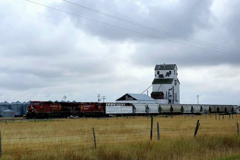
imagesize =
image_caption =Grain elevator in Stirling
flag_size = 145px
image_
seal_size =
image_shield = Stirling-coat of Arms.jpg
shield_size = 125px
shield_size =
blank_emblem_size =
mapsize = 100px
map_caption =
mapsize1 =
map_caption1 =
image_dot_
dot_mapsize = 200px
dot_map_caption = Location of Stirling inAlberta
dot_x = 112 |dot_y = 246
pushpin_
pushpin_label_position =
pushpin_map_caption =
pushpin_mapsize =
|subdivision_type = Country
subdivision_name = flag|Canada
subdivision_type1 = Province
subdivision_name1 = flag|Alberta
subdivision_type2 = Region
subdivision_name2 =Southern Alberta
subdivision_type3 = Census division
subdivision_name3 = 2
subdivision_type4 = County
subdivision_name4 = Warner
government_footnotes =
government_type =
leader_title =Mayor
leader_name = Larry Nilsson
(Past mayors)
leader_title1 = Village Manager
leader_name1 = Scott Barton
leader_title2 = Governing body
leader_name2 = Stirling Village Council
leader_title3 = MP
leader_name3 =Rick Casson
leader_title4 = MLA
leader_name4 =Broyce Jacobs
established_title = Founder
established_date = Theodore Brandley
established_title2 = Founded
established_date2 = 1899
established_title3 = Incorporated
established_date3 =September 3 1901
area_magnitude =
unit_pref =
area_footnotes =
area_total_km2 = 2.64
area_land_km2 =
area_water_km2 =
area_total_sq_mi =
area_land_sq_mi =
area_water_sq_mi =
area_water_percent =
area_urban_km2 =
area_urban_sq_mi =
area_metro_km2 =
area_metro_sq_mi =
population_as_of = 2006
population_footnotes =
population_note =
population_total = 921
population_density_km2 = 349.5
population_density_sq_mi =
population_metro =
population_density_metro_km2 =
population_density_metro_sq_mi =
population_urban =
population_density_urban_km2 =
population_density_urban_sq_mi =
population_blank1_title =
population_blank1 =
population_density_blank1_km2 =
population_density_blank1_sq_mi =
timezone = MST
utc_offset = -7
timezone_DST =
utc_offset_DST =
latd= 49|latm= 30|lats= 08|latNS= N
longd= 112|longm= 31|longs= 00|longEW= W
elevation_footnotes =
elevation_m = 935
elevation_ft =
postal_code_type = Postal code span
postal_code = TOK 2EO
area_code = +1-403
blank_name = Highways
blank_info = Highway 4
Highway 61
Highway 846
blank1_name = Waterways
blank1_info =Etzikom Coulee Kipp Coulee Stirling Lake Milk River Ridge Reservoir
blank2_name = Historic Sites
blank2_info =Galt Historic Railway Park Michelsen Farmstead William T. Ogden House
website = [http://www.villageofstirling.com Village of Stirling]
footnotes =Stirling is a village in Warner County,
Alberta ,Canada . The population was 921 at the 2006 Census. The village is located on Highway 4 31 km (19 mi) southeast ofLethbridge and 72 km (45 mi) northwest of theUnited States-Canada border .History
Stirling was founded on
May 5 1899 by Theodore Brandley. The town was one of two communities that owed its existence to a partnership betweenThe Church of Jesus Christ of Latter-day Saints and Charles A. Magrath of theNorth Western Coal and Navigation Company [ [http://www.prairierails.net/nwcnco.htm North Western Coal and Navigation Company] Retrieved on 2007-08-02] , and is one of only three communities designated as aNational Historic Site of Canada . Stirling was named afterJohn A. Stirling , Managing Director of The Trusts, Executors and Securities Corporation of London, which owned shares in the Alberta Coal and Railway Company.After arriving at the Stirling siding, Theodore Brandley quickly started planning the lay-out of the town. The town site was made up of one square mile (640
acres ), then divided into lots of 10 acres; each with a surveyed road around the entire area with a lane runningnorth andsouth , dividing it into two parcels. The parcels were then again divided,east andwest , making four lots, each 2.5 acres, giving the residents room to build homes, barns and shelters for animals, with large gardens. Theodore planned the town site after thePlat of Zion , [ [http://www.library.cornell.edu/Reps/DOCS/smith.htm Plat Zion] of the city ofZion , byJoseph Smith, Jr . Retrieved on 2007-08-02] which Stirling still follows today, and is recognized as the most well-preserved, Canadian example of the Plat of Zion. For this reason, Stirling is known asStirling Agricultural Village [Parks Canada [http://www.pc.gc.ca/docs/r/ab/sites/stirling_e.asp Village of Stirling National Historic Site of Canada] , Parks Canada, accessed2008-02-26 .]New Stirling
In the 1890s the Alberta Rail and Irrigation laid a narrow gauge line that ran diagonally from Lethbridge to Stirling and then to Coutts. In 1912 the
Canadian Pacific Railway [ [http://www.thecanadianencyclopedia.com/index.cfm?PgNm=TCE&Params=A1ARTA0001322 Canadian Pacific Railway] History of the Railway. Retrieved on 2008-07-05.] bought the rail line and needed extra space for ajunction point for the line between Raymond and Foremost. This junction was named New Stirling, creating a new town latter to be named Maybutt. Due to confusion between the two post offices in Old Stirling and New Stirling, the name was changed to Maybutt. Mr. Fisher who was the original owner and planer of the town site, decided to rename the town after his wife, May Butt.Since the
Dust Bowl era, Maybutt has slowly died off making it a ghost town with few buildings remaining. [ [http://www.ghosttownscanada.ca/gallery/showgallery.php/cat/952 Picture Gallery Ghost towns of Canada] . New Stirling Retrieved on 2008-07-05.]Geography and climate
Stirling is in the municipal district of Warner, and lies 31 km (19 mi) south-east of Lethbridge, at the junction of Highway 4 and Highway 846. The
Milk River Ridge is south of the village, andEtzikom Coulee andKipp Coulee are north of it.Climate
Stirling is subject to
chinooks , which bring temperatures in mid-winter above 10 °C (50 °F). Chinooks bring more than 200 days of wind a year. [ [http://www.theweathernetwork.com/weather/CAAB0291 Weather] Environment Canada. Retrieved on 2008-08-26.]Economy
Historically, Stirling's economy has relied mainly on
agriculture as a main industry. Stirling's location and rich history makestourism another main industry. Stirling has a variety of businesses, [ [http://www.villageofstirling.com/Business/bus%20dir.htm Stirling Business Directory] . Retrieved on 2008-08-31.] such as aconvenience store ,creamery , large concrete terminal grain elevator, a wooden cribgrain elevator now used as ahemp plant, a truck and tractor dealer, a pool, a community-owned campground, and a community park known as Centennial Park.Demographics
In 2006 Stirling had a population of 921 living in 299 dwellings, a 5.0% increase from 2001. The village has a land area of km2 to mi2|2.64|abbr=yes|wiki=yes and a
population density of Pop density km2 to mi2|349.5| spell=UK | abbr=yes.Cite web| url= http://www12.statcan.ca/english/census06/data/profiles/community/Details/Page.cfm?Lang=E&Geo1=CSD&Code1=4802009&Geo2=PR&Code2=48&Data=Count&SearchText=Stirling&SearchType=Begins&SearchPR=01&B1=All&GeoLevel=&GeoCode=4802009 | title= Stirling - Community Profile | author= Statistics Canada| authorlink= Statistics Canada| year= Census 2006 | accessdate= 2007-06-09] The 2008 municipal census reported Stirling has grown to 1041 from 951 in the 2007 municipal census.Fact|date=March 2008According to the
2001 Canadian census Cite web| url= http://www12.statcan.ca/english/profil01/CP01/Details/Page.cfm?Lang=E&Geo1=CSD&Code1=4802009&Geo2=PR&Code2=48&Data=Count&SearchText=Stirling&SearchType=Begins&SearchPR=01&B1=All&Custom= | title= Stirling - Community Profile | author= Statistics Canada| authorlink= Statistics Canada| year= Census 2001 | accessdate= 2007-10-30] , of those respondents who indicated religious affiliation, all but 13% considered themselvesChristian .*Protestant: 78%
*Catholic: 9%
*No religious affiliation: 13%
*Christian Orthodox: 0%
*Christian (unspecified denomination): 0%Government
The village is governed by a village council composed of a
mayor , four councillors and a village manager.Cite web| url=http://www.villageofstirling.com/Council/council.htm | title= Stirling Village Council | author= The Village of Stirling | authorlink= | | accessdate= 2007-10-30] Municipal elections are held every three years.Infrastructure
The village is connected to two highways: Highway 4, which heads south to
Interstate 15 and north toLethbridge , and the historicRed Coat Trail Cite web| url=http://www.thecanadianencyclopedia.com/index.cfm?PgNm=TCE&Params=A1ARTA0009698 | title= Red Coat Trail | author= The Canadian Encyclopedia | authorlink= | | accessdate= 2008-08-05] also known as Highway 61, which heads east to Foremost and then ends in Manyberries.Stirling Emergency Services are provided by the Raymond and District hospital and police station located in Raymond, as well as the village's own fire station, that has served the Stirling and area since 1957.Cite web| url=http://www.geocities.com/stirlingfireamb/ | title= Stirling Emergency Services | author= Stirling Fire Department | authorlink= | | accessdate= 2008-08-05]
Tourism
Stirling's recreational facilitiesCite web| url=http://www.villageofstirling.com/Visit/Reunion%20Centre.htm | title= Stirling's recreational facilities | author= Village of Stirling | authorlink= | | accessdate= 2007-08-02] include ball parks, a swimming pool, a tennis court, a community centre, a picnic area, playgrounds, rodeo grounds, fish pound, and libraryCite web| url=http://www.informalberta.ca/public/service/srvProfileGeneral_Initialize.do;jsessionid=313AB5A892959771C4397F983B09AD2F?serviceQueryId=1007767 | title= Theodore Brandley Library | author= Chinook Arch Regional Library System | authorlink= | | accessdate= 2007-08-02] . The
Milk River Ridge Reservoir Cite web| url=http://www.travelwestvisual.com/TravelAlberta/Home/Pages/AlbertaSouth/LethAr/MilkRivRidge/Pict/Pict154525F120.htm | title= Milk River Ridge Reservoir | author= County of Warner | authorlink= | | accessdate= 2007-08-02] south of Stirling supports water recreation in the summer months, andStirling Lake , also known as Michelsen Marsh, north of Stirling supports bird watchers year-round.Local attractions
;Stirling Settler Days
After Stirling's founding on
May 5 1899 , the 24th of July, known as "Pioneer Day ", now calledStirling Settler Days , was celebrated to mark theMormon pioneers ' arrival in theSalt Lake Valley .;Michelsen Farmstead: The
Michelsen Farmstead Cite web| url=http://www.villageofstirling.com/Visit/Michelsen.htm | title= Michelsen Farmstead | author= Village of Stirling | authorlink= | | accessdate= 2007-08-02] is a typicalfarmstead of the 1800s era, located in Stirling. It was declared a Provincial Historic Site of Alberta in 2001, and has been restored back to its original 19th century Victorian style.;Galt Historic Railway Park:The
Galt Historic Railway Park Cite web| url=http://www.villageofstirling.com/Visit/Galt.htm | title= Galt Historic Railway Park | author= Village of Stirling | authorlink= | | accessdate= 2007-08-02] has displays of life and travel in the 1880s in the restored 1890North West Territories International Train Station fromCoutts, Alberta ,Canada andSweetgrass, Montana , USA. The station was moved to the current location just outside Stirling, in 2000.;William T. Ogden House: The
William T. Ogden House is aNeo-Classical style house that is declared as a Provincial historic Site of Alberta located in Stirling. Every year aroundHalloween the owners of the home decorate the convert|7000|sqft|m2|abbr=on house as a livehaunted house , making it the largest haunted house inSouthern Alberta . [William T. Ogden House [http://www.freewebs.com/hauntedmansionstirling/index.htm Stirling Haunted Mansion] . Retrieved on 2007-08-02];Lost Frontier Mini-Railway: The
Lost Frontier Mini-Railway [William T. Ogden House [http://www.freewebs.com/lostfrontierminirailroad/index.htm Lost Frontier Mini-Railway.] Retrieved on 2007-08-02] is a small train park open by booking from May to October and is a very popular local attraction. Located on the grounds of the William T. Ogden Home, the park also has apetting zoo .Regional attractions
;Devil's Coulee Dinosaur Heritage Museum:The
Devil's Coulee Dinosaur Heritage Museum Cite web| url=http://www.devilscoulee.com/Main.html | title= Devil's Coulee Dinosaur Heritage Museum | author= Village of Warner | authorlink= | | accessdate= 2007-08-02] features aHadrosaur (duck-billed dinosaur) nest and embryo, ancient fossils, dinosaur models, located in the Village of Warner.;Waterton Lakes National Park
Waterton Lakes National Park is a national park located in the extreme southwest corner of Alberta, Canada, 40 km west of Cardston, and bordersGlacier National Park in Montana, USA.Waterton Lake s was Canada's fourth national park formed in 1895. TheRocky Mountains rise suddenly out of the rolling prairies in the park. Amid the peaks are the three Waterton Lakes, carved out of the rock by ancientglacier s.;Writing On Stone Provincial Park
Writing-on-Stone Provincial Park , 125 km east of Cardston, is one of the largest areas of protected prairie in the Alberta park system, and serves as both anature preserve and protection for the largest concentration ofrock art , created by Plains People. There are over 50 rock art sites, with thousands of figures, as well as numerous archeological sites.Education
Stirling has one school that covers
Kindergarten through grade 12 in the Westwind School Division. Enrollment forStirling School [ [http://www.westwind.ab.ca/index.php?option=com_content&task=view&id=53&Itemid=88 Stirling School] . Retrieved on 2007-08-02] was 322 in 2006.Stirling School is home to a few athletic teams, from
volleyball tobadminton , evengolf .Sports
The high school girls basketball team won the 1A girls basketball provincial championships in 1997–1999. They placed in three other provincial championships between 1996 and 2006. The Lakettes won or placed second for 6 straight years between 1996–2003.
The high school boys basketball team won the 1A boys basketball provincial championships in 2001, 2003 and 2006. They placed second in three other provincial championships between 1996 and 2006. The Lakers have played in 6 of the last 10 championships. [ [http://www.asaa.ca/pages/sports/basketball/results/results.php3#2005 Alberta Schools' Athletic Association website] Retrieved on 2006-03-01.]
In 2006 the final game was a decisive 98-68 victory over the third-ranked Youngstown Falcons. Besides the provincial title, the Stirling Lakers recorded a season of 30 wins, 9 losses, and 3 other tournament champion titles, including the 1A South Zone Title, the Picture Butte Sugar King Invitational, and the Mccoy Invitational.
The Stirling Lakers followed up their 2006 season with another provincial title in 2007. The Lakers were victorious in the championship game over their rivals from Foremost. On their way to provincials, the Lakers were also crowned South Zone champions.
In 2008 Stirling hosted provincials and ended up winning their third provincial title in a row.
Media
Stirling has many different types of news papers such as Westwind Weekly, Lethbridge Herald, and Prairie Post. At one time, Stirling had a newspaper of its own called the Stirling Star. [ [http://www.telusplanet.net/public/vilstir/star.htm New Stirling Star] . Retrieved on 2007-08-02] In the 1980s Stirling also hosted the cast of a film called "
Pure Escape " staringJames Garner . Fact|date=June 2008Newspapers
*"
Lethbridge Herald ", the most read newspaper inLethbridge and Southern Alberta.Fact|date=June 2008*"Prairie Post", a news paper focused on Alberta and the southwest region of
Saskatchewan .*"
Stirling Star " was Stirling's newspaper printed in New Stirling until the late 1930s.*"Westwind Weekly", a weekly newspaper featuring news from Stirling and surrounding communities.
Movies
*
Pure Escape , movie shot throughout Southern Alberta and Stirling in the 1980s.Notable people
* Theodore Brandley, one of the first missionaries called to
Canada from his former home inRichfield, Utah ; one of his missions was to helped colonize Stirling.Cite web| url=http://waltonfeed.com/stirling/history/people/tbrandle.html | title= Biography of Theodore Brandley | author= Stirling Historical Society | authorlink= | | accessdate= 2007-08-02]*
Reg Kesler , resided on a ranch near Stirling, and was put in the record books in 1948, by becoming the Canadian Champion All-Around at theCalgary Stampede . In total Kesler won a total of $1,960 along with the first trophy saddle awarded by the C.P.A.. and again winging the title two more times in 1951 and 1953. [ [Canadian Pro-Rodeo Hall of Fame http://www.canadianprorodeohalloffame.com/inductees.php?year=1989] | accessdate= 2007-08-02]*
Glen Michelson , first native son to enter theRoyal Canadian Mounted Police .Fact|date=June 2008*
Grant L. Spackman , member of theRoyal Canadian Air Force for 5 years and was awarded the Distinguished Flying Cross medal fromKing George VI .Fact|date=January 2008See also
*
Scottish place names in Canada
*List of national historic sites of Canada
*List of provincial historic sites of Alberta
*List of communities in Alberta
*Villages of Alberta References
External links
* [http://waltonfeed.com/stirling/history/ceremony/index.html Stirling's National Historic Site Designation Ceremony]
* [http://www.picturesofcanada.ca/gallery/main.php/v/Alberta/Stirling/ Pictures Of Stirling]
* [http://www.villageofstirling.com Village of Stirling]
* [http://upload.wikimedia.org/wikipedia/en/f/fd/Flag_of_Stirling_Ab.gifFlag of Stirling]Canadian City Geographic Location (8-way)
Northwest =Lethbridge
North =

Wikimedia Foundation. 2010.