- Maybutt, Alberta
-
Maybutt — Unincorporated community — 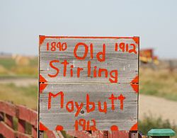
Nickname(s): The Junction Town (1912)[1] New Stirling (1910) Location of Maybutt in Alberta

Coordinates: 49°30′08″N 112°31′00″W / 49.50222°N 112.5166667°W Country Canada Province Alberta Region Southern Alberta Census division 2 County Warner Founded 1910 Government - Governing body Warner County Council - MP Rick Casson - MLA Broyce Jacobs Elevation 935 m (3,068 ft) Population (1920) - Total 250 Time zone MST (UTC−7) - Summer (DST) MDT (UTC−6) Postal code span TOK 2EO Area code(s) +1-403 Highways Highway 4
Highway 61Waterways Etzikom Coulee
Kipp Coulee
Stirling Lake
Milk River Ridge ReservoirMaybutt also known as “New Stirling” or "New Town" is a former locality in Warner County, Alberta, Canada. The unincorporated community is situated 1 km north of the old town of Stirling just off the CANAMEX Corridor between Lethbridge and the United States-Canada border. Although the settlement once boasted many businesses with a population of 250 residents, it never made village status,[2] because the community never grew to the three hundred residents it needed to become a village.
Contents
History
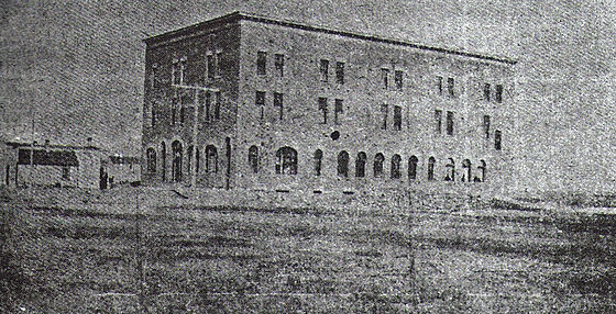
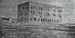 Prairie Queen Hotel corner of First Ave. & Front St., Maybutt
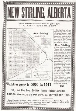 Advertisement poster for the town of "New Stirling" later Maybutt.
On May 5, 1899, Theodore Brandley and the first band of LDS settlers arrived at the Stirling railway siding, east of present day Maybutt. Theodore Brandley quickly started planning out the new town of Stirling south of present day Maybutt. The town very quickly began to boom.
In 1909-1910 the Canadian Pacific Railway (C.P.R.) had the intentions to buy up the Alberta Coal and Railway Co.[3] line that ran diagonally from Lethbridge to Stirling then Great Falls, Montana. Soon after C.P.R. needed extra space for a junction point for the construction of the Stirling-Weyburn branch line, with speculation of Canadian National Railway bringing a branch line from Fort Macleod to Stirling.
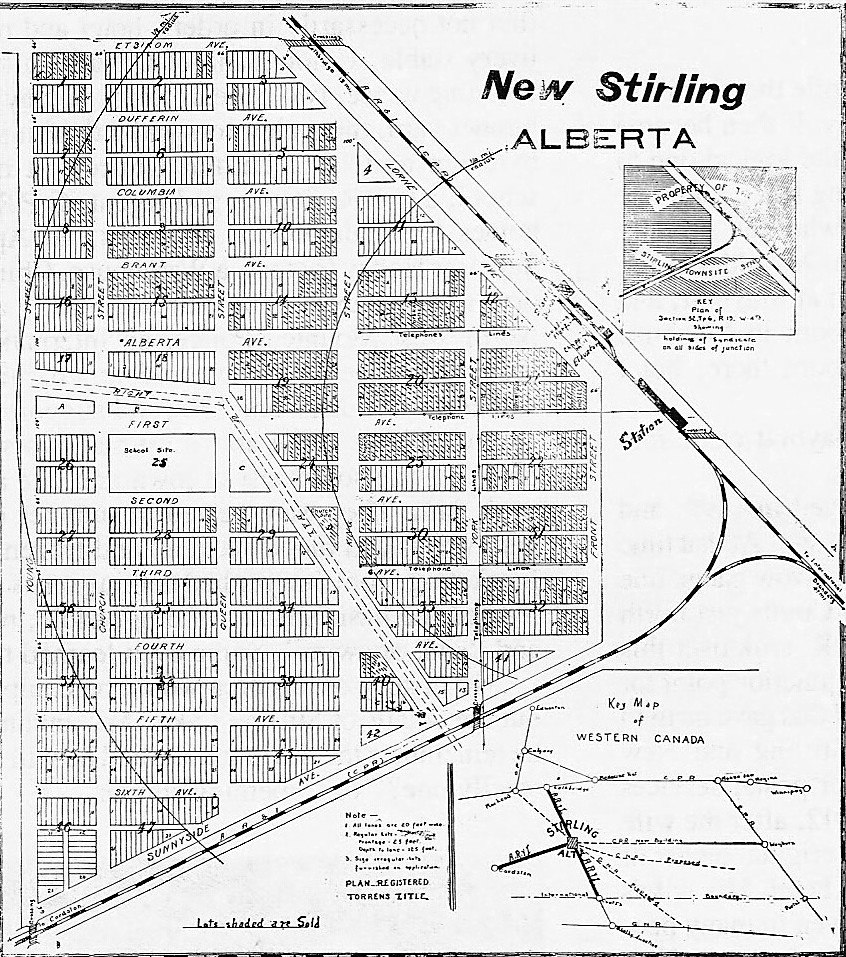
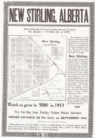
This junction lied on Mr. William Fisher's land, a real estate promoter and newcomer to Alberta. Mr. Fisher took advantage of this and began planning out his new town, New Stirling. The location was an ideal spot for a new town to be placed. Mr. Fisher had printed many posters to send out east to promote New Stirling. Some of his posters stated "Watch us Grow to 5,000 in 1913"; others were far-fetched, as he put a photo of a yacht on the tree-covered shores of Stirling Lake north of town, which at the time had not a tree for miles. Mr. Fisher had the idea to build a large hotel and construction of the Prairie Queen Hotel began. It was an elaborate three storey brick veneered hotel with all the modern conveniences of the time such as steam heat, electric lights, and even a bar room that was never used as such. Upon completion the Prairie Queen was stated to be the largest hotel ever built in a new town west of Winnipeg.
In 1912, due to confusion between Stirling and New Stirling’s names, New Stirling was changed to Maybutt, after Mr. William Fisher’s wife's maiden name "May Butt".
During the boom years 1910-1920 Maybutt had many of the amenities of a larger town. It had livery stables, a Union Bank of Canada branch, a two-storey boarding house, two general stores, a dry business, a lumber yard, three grain elevators, a flour mill, a Presbyterian and late United Church, some C.P.R. section homes for rail maintenance, an Apiary and Superior Honey Factory, a warehouse, a Chinese laundry and restaurant, a newspaper (Stirling Star),[4] a resident North-West Mounted Police, an International Harvest Machine Company and a large three-storey brick veneered hotel, boasted as the largest hotel ever built in a new town in Western Canada.
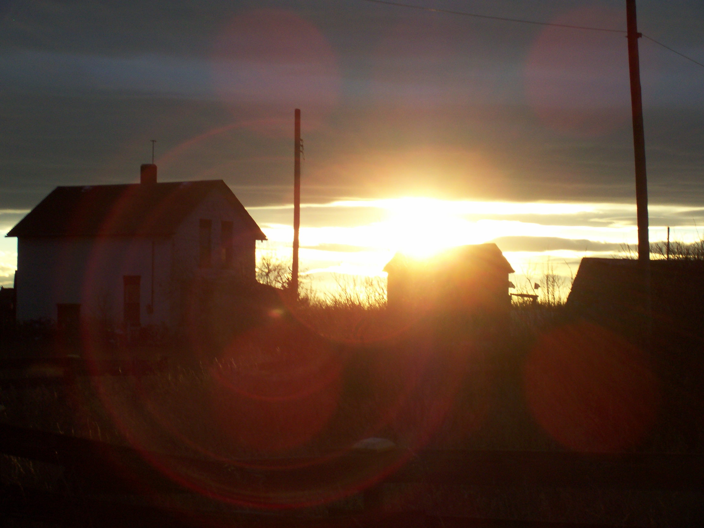
 Sun setting on Maybutt.
Beginning in the mid 1920-1930s the Dust Bowl era of the 1930s hit Maybut pretty hard. Residents left Maybutt and Stirling in hopes to find greener pastures somewhere else, due to poor crop yields, droughts, and falling grain prices. Stirling’s population had dipped from about 600 residents to as low as 366 in 1926, while Maybutt's peak population, 250 never grew to the 300 people needed to incorporate as a village under Alberta's Municipal affairs,[5] citizens of Maybutt slowly started to pack up and leave sometimes taking their homes and stores with them, leaving just a handful of hardy citizens remaining.
Today due to Maybutt's proximity to the city of Lethbridge people have begun to move homes from around the area to Maybutt, nearly doubling Maybutt's population to approximately 12 people. Although not the same as in its heyday even with newer construction, Maybutt continues to die more and more and is slowly being replaced with new development. The only original buildings that remains are three pioneer houses, a grain elevator[6] and vacant outbuildings.[7]
Education
Maybutt's first classes were held in 1910 in the Presbyterian Church and was "one-room" where all grades were taught. A few years after classes were then moved to the former Chinese restaurant for about one year then moved to the Prairie Queen Hotel in the former Union Bank room. In the 1920s plans were drawn up for a new school site within the town, but due to dwindling attendants the plans never came through and in 1924 students were transferred to the Stirling School.
Attractions
Local attractions
- Galt Historic Railway Park
The Galt Historic Railway Park located 1 km north of Stirling is another popular museum which displays of life and travel in the 1880s to 1920s are set up in the restored 1890 North-West Territories International Train Station from Coutts, Alberta, Canada, and Sweetgrass, Montana, USA. The station was moved to the current location near Stirling in 2000 and is added onto every year. Future plans to move the 1925 Oglvie grain elevator from Wrentham for display along the station in the 36-acre (150,000 m2) park is still in the planning stages.
- Stirling Agricultural Village
Stirling Agricultural Village is a National Historic Site of Canada, and was listed as one of only three communities in Canada designated as a National Historic Site because of the community’s well preserved settlement pattern that follows the Plat of Zion model.[8] Located within the village are two museums the Michelsen Farmstead a totally restored 1900s home showcasing rual life in Alberta in the 1930s. Listed as a Provincial Historic Site in 2001.,[9] and the Galt Historic Railway Park.
Regional attractions
- Devil's Coulee Dinosaur Heritage Museum
The Devil's Coulee Dinosaur Heritage Museum[10] features a Hadrosaur (duck-billed dinosaur) nest and embryo, ancient fossils, dinosaur models, located in the Warner.
- Warner elevator row
The Warner elevator row is a row of historic wood-cribed grain elevators. A total of six elevators still stand in a row from south to north alongside the Canadian Pacific Railway on the east entrance of the village of Warner. Due to the loss of a vast amount of Alberta's many grain elevators, the elevator row in Warner remains the very last row of elevators in Alberta. Only two elevator rows remain in Canada, Warner's row and the elevators in Inglis, Manitoba.
- Waterton Lakes National Park
Waterton Lakes National Park is a National Park located in the extreme southwest corner of Alberta, Canada, 40 km west of Cardston, and borders Glacier National Park in Montana, USA. Waterton Lakes was Canada's fourth National Park formed in 1895. The Rocky Mountains rise suddenly out of the rolling prairies in the park. Amid the peaks are the three Waterton Lakes, carved out of the rock by ancient glaciers.
- Writing On Stone Provincial Park
Writing-on-Stone Provincial Park, is one of the largest areas of protected prairie in the Alberta park system, and serves as both a nature preserve and protection for the largest concentration of rock art, created by Plains People. There are over 50 rock art sites, with thousands of figures, as well as numerous archeological sites.
Media
Maybutt has many different types of news papers such as Westwind Weekly, Lethbridge Herald, and Prairie Post. At one time, Maybutt once had a newspaper of its own called the Stirling Star.[11] In the 1980s Stirling and Maybutt also hosted the cast of a film called "Pure Escape" starring James Garner.[citation needed]
Newspapers
- Lethbridge Herald, the most read newspaper in Lethbridge and Southern Alberta.[citation needed]
- Prairie Post, a news paper focused on Alberta and the southwest region of Saskatchewan.
- Stirling Star was Stirling's newspaper printed in New Stirling until the late 1930s.
- Westwind Weekly, a weekly newspaper featuring news from Stirling and surrounding communities.
Movies
- Pure Escape, movie shot throughout Southern Alberta and Stirling in the 1980s.
See also
- List of places with fewer than ten residents
- List of attractions and landmarks in Stirling
- List of communities in Alberta
- List of ghost towns in Alberta
- Stirling, Alberta
- Prairie Queen Hotel
References
- ^ Stirling the Junction Town Lethbridge Herald Archives Retrieved on 2008-09-28.
- ^ Municipal Government Act – Government of Alberta. Retrieved on 2007 – 08-02
- ^ History of the Canadian Pacific Railway. Retrieved on 2007 – 08-02
- ^ The Stirling Star. Retrieved on 2007-08-02
- ^ Municipal affairs. Retrieved on 2007-08-02
- ^ Photo Gallery Grain Elevators of Canada . Retrieved on 2007-08-02
- ^ Picture Gallery Ghost towns of Canada. Retrieved on 2007-08-02
- ^ Parks Canada (June 2007). "Village of Stirling National Historic Site". http://www.pc.gc.ca/docs/r/ab/sites/stirling_e.asp. Retrieved 2007-11-13.
- ^ Village of Stirling. "Michelsen Farmstead". http://www.villageofstirling.com/Visit/Michelsen.htm. Retrieved 2007-11-13.
- ^ Village of Warner. "Devil's Coulee Dinosaur Heritage Museum". Archived from the original on 2007-07-29. http://web.archive.org/web/20070729024805/http://www.devilscoulee.com/Main.html. Retrieved 2007-08-02.
- ^ Stirling Star Stirling Historic Society. Retrieved on 2007 – 08-02
External links
- OurRoots.ca - Maybutt: Stirling Its Story and People: 1899-1980 By Mary Pengilly Duncan

Lethbridge Coaldale Taber Raymond 
Wrentham  Maybutt

Magrath Stirling New Dayton  Subdivisions of Alberta
Subdivisions Regions · Census divisions · Municipal districts (counties) · Specialized municipalities · School districts · Regional health authoritiesCommunities Cities · Towns · Villages · Summer villages · Hamlets · Indian reserves · Métis settlements · Ghost towns · Designated placesCities and Urban
Service AreasAirdrie · Brooks · Calgary · Camrose · Cold Lake · Edmonton (capital) · Fort McMurray · Fort Saskatchewan · Grande Prairie · Lacombe · Leduc · Lethbridge · Lloydminster · Medicine Hat · Red Deer · Sherwood Park · Spruce Grove · St. Albert · Wetaskiwin Category ·
  Portal ·
  WikiProject
Coordinates: 49°30′8″N 112°31′0″W / 49.50222°N 112.516667°W
Categories:- Warner County, Alberta
- Stirling, Alberta
- Unincorporated communities in Alberta
- Ghost towns in Alberta
- Populated places established in 1910

Wikimedia Foundation. 2010.