- Big Rock (glacial erratic)
-
 Big Rock
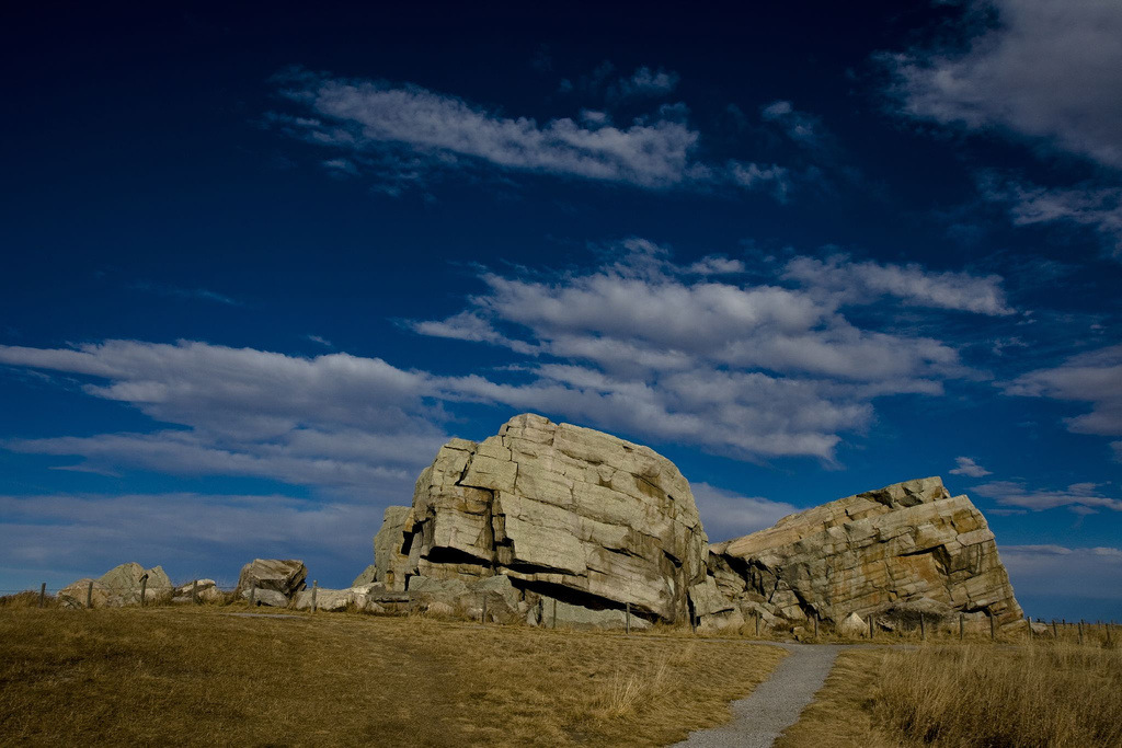
Big Rock (also known as Okotoks Erratic) is a glacial erratic situated between the towns of Okotoks and Black Diamond, Alberta, Canada (18 kilometres south of Calgary). The 15,000 tonne (16,500 short ton) quartzite boulder is the world's largest known glacial erratic.[1]
Contents
History
Big Rock is one of several thousand erratics found in Alberta and Montana called the Foothills Erratics Train, which originated from a landslide in the Tonquin Valley of Jasper National Park, from Lower Cambrian-aged Gog Group.[2] Big Rock was transported on the Cordilleran Ice Sheet approximately 12 to 18 thousand years ago[3] to its present location.
The people of the Blackfoot First Nation used Big Rock as a landmark for finding a crossing over the Sheep River (where Okotoks stands today) long before European settlement. The town's name Okotoks is derived from "o'kotok" [ˈokətok], meaning "Large Rock" in the Blackfoot language. The rock also contains native pictographs and was considered a medicine rock to the natives. In the 1970s the government declared it a Provincial Historic Site in order to protect its geological and cultural importance.
The first geologist to discover Big Rock was James Hector in 1863, who misidentified the feature as a klippe.[2]
Present day
The erratic is clearly visible from the side of Highway 7, and public parking is available at the turn-off. While there is a fence around the Big Rock and a sign telling people not to climb, thousands of people visit the rock and ignore the warnings to either boulder or climb the 9 metre tall erratic.
Erosion has caused noticeable signs of mass wasting documented in 1991.[citation needed]
In popular culture
Big Rock Brewery in Calgary is named after Big Rock.
References
- ^ "Okotoks Erratic". Government of Alberta. http://www.culture.alberta.ca/museums/historicsiteslisting/okotokserratic/default.aspx.
- ^ a b Lionel E. Jackson, Jr., Elizabeth R. Leboe, Edward C. Little, Philip J. Holme, Stephen R. Hicock, and Kazuharu Shimamura (1999). CANQUA 99 Guidebook: Late Quaternary Geology of the Foothills, from Calgary to the Alberta–Montana Border. http://www3.telus.net/lejgeology/etrain/PDF/CANQUA%2099%20SW%20AB%20Field%20Guide.pdf.
- ^ Jackson, Lionel E.; Fred M. Phillips, and Edward C. Little (1999). "Cosmogenic 36Cl dating of the maximum limit of the Laurentide Ice Sheet in southwestern Alberta". Canadian Journal of Earth Sciences 36 (8): 1347–1356. doi:10.1139/cjes-36-8-1347. http://pubs.nrc-cnrc.gc.ca/cgi-bin/rp/rp2_abst_e?cjes_e99-038_36_ns_nf_cjes8-99.
Continental Glaciations General Landforms ErosionalDepositionalDrumlin · Drumlin field · Erratic block · Moraine · Pulju moraine · Rogen moraine · Terminal moraine · Till plain · Veiki moraine
GlacifluvialNorth American Places CanadianArrowhead Provincial Park, Ontario • Big Rock (glacial erratic), Alberta • Cypress Hills (Canada), Saskatchewan • Foothills Erratics Train, Alberta • Ovayok Territorial Park, Nunavut • Lion's Head Provincial Park, Ontario • Origin of the Oak Ridges Moraine, Ontario • Eramosa River, Ontario • Eskers Provincial Park, British ColumbiaUnited StatesIce Age Floods National Geologic Trail, Idaho, Oregon & Washington • Glacial Lake Missoula, Montana • Glacial Lake Wisconsin, Wisconsin • Interstate State Park, Minnesota & Wisconsin • Kelleys Island, Ohio • Kettle Moraine State Forest, Wisconsin • Lake Bonneville, Utah • Lake Lahontan, Nevada • Mill Bluff State Park, Wisconsin • Oneida Lake, New York • Two Creeks Buried Forest State Natural Area, Wisconsin • Withrow Moraine and Jameson Lake Drumlin Field, Washington • Yosemite National Park, California • Chippewa Moraine State Recreation Area, Wisconsin • Coteau des Prairies, South Dakota • Devil's Lake State Park, Wisconsin • Glacial Lakes State Park, Minnesota • Horicon Marsh State Wildlife Area, Wisconsin • Ice Age National Scientific Reserve, Wisconsin • Ice Age Trail, WisconsinEurasian and Antarctic Places Time periods Illinoian Stage • Interglacial • Interstadial • Pre-Illinoian Stage • Last glacial period • Little Ice Age • Older Dryas • Pleistocene • Quaternary glaciation • Sangamonian Stage • Wisconsin glaciation • Younger DryasCategory:GlaciersCoordinates: 50°42′21.18″N 114°04′35.12″W / 50.7058833°N 114.0764222°W
Categories:- Foothills No. 31, Alberta
- Landforms of Alberta
- Glacial erratics
- Provincial historic sites of Alberta

Wikimedia Foundation. 2010.