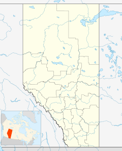
- Madden, Alberta
-
Location of Madden in Alberta
Madden is a hamlet in southern Alberta under the jurisdiction of Rocky View County.[1]
Madden is located approximately 46 kilometres (29 mi) north of Downtown Calgary on Highway 574, 16 kilometres (9.9 mi) west of the Town of Crossfield on Highway 2A and 19 kilometres (12 mi) west of Highway 2 (the Calgary-Edmonton Corridor).
The hamlet was named after Bernard Madden, and early pioneer and a prominent rancher who arrived in the area in 1876. The post office was opened on May 1, 1931.
Madden, while small, boasts a community hall and curling rink, meat processor, campground, fire station and an 18-hole golf course. Madden has also been host to a few film crews including the recent production 'Mayerthorpe' (seen on CTV) which was shot at various locations near the hamlet.
Madden was once located on a Canadian Pacific Railway spur from Collicutt to Cremona and had two elevators. The rail grade can still be seen as it goes west from the hamlet through the Ag Society grounds and east towards Nier Lakes.
Contents
Climate
Climate data for Madden Month Jan Feb Mar Apr May Jun Jul Aug Sep Oct Nov Dec Year Record high °C (°F) 14.5
(58.1)22.8
(73.0)21
(70)29.5
(85.1)32.5
(90.5)33.5
(92.3)34
(93)34
(93)33
(91)28
(82)19.5
(67.1)18.5
(65.3)34
(93)Average high °C (°F) −1.8
(28.8)0.5
(32.9)4.1
(39.4)11.1
(52.0)16.3
(61.3)19.6
(67.3)21.8
(71.2)21.9
(71.4)17
(63)11.8
(53.2)2.1
(35.8)−1.1
(30.0)10.3 Daily mean °C (°F) −7.8
(18.0)−5.6
(21.9)−1.8
(28.8)4.4
(39.9)9.5
(49.1)13.1
(55.6)15
(59)14.8
(58.6)10.2
(50.4)5.1
(41.2)−3.5
(25.7)−6.8
(19.8)3.9 Average low °C (°F) −13.8
(7.2)−11.7
(10.9)−7.7
(18.1)−2.4
(27.7)2.5
(36.5)6.6
(43.9)8.3
(46.9)7.7
(45.9)3.3
(37.9)−1.6
(29.1)−9
(16)−12.4
(9.7)−2.5 Record low °C (°F) −39.5
(−39.1)−38.5
(−37.3)−31.5
(−24.7)−19.5
(−3.1)−9
(16)−2.5
(27.5)−0.5
(31.1)−4
(25)−9.5
(14.9)−27
(−17)−35.5
(−31.9)−38.5
(−37.3)−39.5
(−39.1)Precipitation mm (inches) 16
(0.63)11.4
(0.449)21
(0.83)28.4
(1.118)63.1
(2.484)82.5
(3.248)75.1
(2.957)65.4
(2.575)53.7
(2.114)17.3
(0.681)17.6
(0.693)15
(0.59)466.5
(18.366)Source: Environment Canada[2] See also
- List of communities in Alberta
- List of hamlets in Alberta
References
- ^ Alberta Municipal Affairs (2010-04-01). "Specialized and Rural Municipalities and Their Communities". http://municipalaffairs.gov.ab.ca/documents/msb/2010-ruralmun.pdf. Retrieved 2010-06-06.
- ^ Environment Canada—[1]. Retrieved 6 April 2010.
Karamitsanis, Aphrodite (1992). Place Names of Alberta – Volume II, Southern Alberta, University of Calgary Press, Calgary, Alberta.
Read, Tracey (1983). Acres and Empires – A History of the Municipal District of Rocky View, Calgary, Alberta.
External links
- Rocky View County's official website
- Rocky View County's community profile on Alberta First
- Calgary-Edmonton Corridor in Alberta
- Madden Agriculture Society Webpage (contact info for ball diamond/hall/curling rink/campground rentals)

Cremona Didsbury Carstairs 
Bottrel 
Crossfield  Madden

Cochrane Bearspaw Airdrie
Calgary Subdivisions of Alberta
Subdivisions Regions · Census divisions · Municipal districts (counties) · Specialized municipalities · School districts · Regional health authoritiesCommunities Cities · Towns · Villages · Summer villages · Hamlets · Indian reserves · Métis settlements · Ghost towns · Designated placesCities and Urban
Service AreasAirdrie · Brooks · Calgary · Camrose · Cold Lake · Edmonton (capital) · Fort McMurray · Fort Saskatchewan · Grande Prairie · Lacombe · Leduc · Lethbridge · Lloydminster · Medicine Hat · Red Deer · Sherwood Park · Spruce Grove · St. Albert · WetaskiwinCoordinates: 51°26′2″N 114°16′57″W / 51.43389°N 114.2825°W
Categories:- Rocky View County, Alberta
- Hamlets in Alberta
- Calgary Region
- Calgary Region geography stubs
Wikimedia Foundation. 2010.

