- Cheshire County, New Hampshire
-
Cheshire County, New Hampshire 
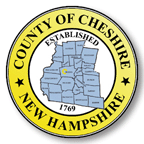
Seal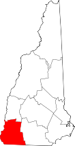
Location in the state of New Hampshire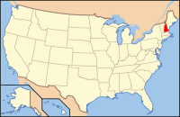
New Hampshire's location in the U.S.Founded 1769 Seat Keene Largest city Keene Area
- Total
- Land
- Water
729.63 sq mi (1,890 km²)
707.40 sq mi (1,832 km²)
22.23 sq mi (58 km²), 2.98%Population
- (2010)
- Density
77,117
109/sq mi (42/km²)Website co.cheshire.nh.us Cheshire County is a county located in the U.S. state of New Hampshire. As of 2010, the population was 77,117.[1] Its county seat is Keene.[2]
Cheshire was one of the five original counties of New Hampshire, and is named for Cheshire in England. It was organized in 1771 at Keene.
Contents
Geography
According to the U.S. Census Bureau, the county has a total area of 729 square miles (1,888 km2), of which 707 sq mi (1,831 km2) is land and 22 sq mi (57 km2) (2.98%) is water. The highest point in Cheshire county is Mount Monadnock, in the northwestern part of Jaffrey, at 3,165 feet (965 m).
Adjacent counties
- Sullivan County (north)
- Hillsborough County (east)
- Worcester County, Massachusetts (southeast)
- Franklin County, Massachusetts (southwest)
- Windham County, Vermont (west)

Sullivan County Windham County, Vermont 
Hillsborough County  Cheshire County, New Hampshire

Franklin County, Massachusetts Worcester County, Massachusetts Geographical landmarks
Demographics
Historical populations Census Pop. %± 1790 28,753 — 1800 38,825 35.0% 1810 40,988 5.6% 1820 45,376 10.7% 1830 27,016 −40.5% 1840 26,429 −2.2% 1850 30,144 14.1% 1860 27,434 −9.0% 1870 27,265 −0.6% 1880 28,734 5.4% 1890 29,579 2.9% 1900 31,321 5.9% 1910 30,659 −2.1% 1920 30,975 1.0% 1930 33,685 8.7% 1940 34,953 3.8% 1950 38,811 11.0% 1960 43,342 11.7% 1970 52,364 20.8% 1980 62,116 18.6% 1990 70,121 12.9% 2000 73,825 5.3% 2010 77,117 4.5% [3][4][5] As of the census[6] of 2000, there were 73,825 people, 28,299 households, and 18,790 families residing in the county. The population density was 104 people per square mile (40/km²). There were 31,876 housing units at an average density of 45 per square mile (17/km²). The racial makeup of the county was 97.75% White, 0.37% Black or African American, 0.31% Native American, 0.47% Asian, 0.04% Pacific Islander, 0.18% from other races, and 0.89% from two or more races. 0.72% of the population were Hispanic or Latino of any race. 16.2% were of English, 13.1% French, 12.7% Irish, 9.3% American, 8.7% French Canadian, 6.7% Italian and 6.5% German ancestry according to Census 2000. 95.5% spoke English, 1.4% French and 1.2% Spanish as their first language.
There were 28,299 households out of which 30.60% had children under the age of 18 living with them, 53.50% were married couples living together, 9.00% had a female householder with no husband present, and 33.60% were non-families. 25.50% of all households were made up of individuals and 9.60% had someone living alone who was 65 years of age or older. The average household size was 2.47 and the average family size was 2.96.
In the county the population was spread out with 23.30% under the age of 18, 11.70% from 18 to 24, 27.00% from 25 to 44, 24.30% from 45 to 64, and 13.70% who were 65 years of age or older. The median age was 38 years. For every 100 females there were 94.90 males. For every 100 females age 18 and over, there were 91.70 males.
The median income for a household in the county was $42,382, and the median income for a family was $51,043. Males had a median income of $33,821 versus $25,328 for females. The per capita income for the county was $20,685. About 4.40% of families and 8.00% of the population were below the poverty line, including 8.50% of those under age 18 and 6.30% of those age 65 or over.
Politics
Presidential election results[7] Year Democrat Republican 2008 63.0% 26,971 35.5% 15,205 2004 59.1% 24,438 39.8% 16,463 2000 52.1% 17,382 41.3% 13,793 Cities and towns
- Richmond
- Rindge
- Roxbury
- Stoddard
- Sullivan
- Surry
- Swanzey
- West Swanzey, a census-designated place
- Troy
- Walpole
- Westmoreland
- Winchester
See also
References
- ^ United States Census Bureau, American FactFinder, 2010 Census figures. Retrieved March 23, 2011.
- ^ "Find a County". National Association of Counties. http://www.naco.org/Counties/Pages/FindACounty.aspx. Retrieved 2011-06-07.
- ^ http://www.census.gov/population/www/censusdata/cencounts/files/nh190090.txt
- ^ http://factfinder2.census.gov/faces/tableservices/jsf/pages/productview.xhtml?pid=DEC_10_PL_QTPL&prodType=table
- ^ http://mapserver.lib.virginia.edu/
- ^ "American FactFinder". United States Census Bureau. http://factfinder.census.gov. Retrieved 2008-01-31.
- ^ "Dave Leip's Atlas of U.S. Presidential Elections". http://uselectionatlas.org/RESULTS/. Retrieved 2011-06-11.
External links
- Official Cheshire County web site
- Cheshire information pages at the University of New Hampshire
- National Register of Historic Places listing for Cheshire County
- Keene Pumpkin Festival
Municipalities and communities of Cheshire County, New Hampshire City 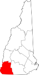
Towns Alstead | Chesterfield | Dublin | Fitzwilliam | Gilsum | Harrisville | Hinsdale | Jaffrey | Marlborough | Marlow | Nelson | Richmond | Rindge | Roxbury | Stoddard | Sullivan | Surry | Swanzey | Troy | Walpole | Westmoreland | Winchester
Villages Ashuelot | Chesham | Drewsville | East Swanzey | North Walpole | Poocham | Spofford | West Swanzey
Categories:- New Hampshire counties
- Cheshire County, New Hampshire
- States and territories established in 1769


Wikimedia Foundation. 2010.