- Mont Vernon, New Hampshire
-
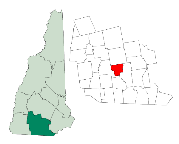
Mont Vernon, New Hampshire — Town — Location in Hillsborough County, New Hampshire
Coordinates: 42°53′40″N 71°40′27″W / 42.89444°N 71.67417°WCoordinates: 42°53′40″N 71°40′27″W / 42.89444°N 71.67417°W Country United States State New Hampshire County Hillsborough Incorporated 1803 Government – Board of Selectmen John Quinlan, Jr., Chair
John (Jack) Esposito
Paul AppleArea – Total 16.7 sq mi (43.3 km2) – Land 16.6 sq mi (43.0 km2) – Water 0.1 sq mi (0.2 km2) 0.48% Elevation 820 ft (250 m) Population (2010) – Total 2,409 – Density 144.3/sq mi (55.7/km2) Time zone Eastern (UTC-5) – Summer (DST) Eastern (UTC-4) ZIP code 03057 Area code(s) 603 FIPS code 33-49140 GNIS feature ID 0873670 Website town.mont-vernon.nh.us Mont Vernon is a town in Hillsborough County, New Hampshire, United States. The population was 2,409 at the 2010 census.[1]
It is not clear why it is spelled differently from the many other towns in the United States named after Mount Vernon, the home of George Washington. Some say the "u" in "Mount" was accidentally dropped by a town clerk filling out official papers; some say the change was made deliberately to draw attention to the town; some say it uses the French spelling of "mont" as a nod to what was then the region's large French-Canadian population. According to town histories, as late as the 1920s, there was some dispute about how to spell the name, with the post office and one of its most prominent hotels using a "u" for many decades.
Contents
History
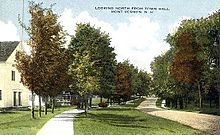 North from Town Hall c. 1915
Mont Vernon broke away from neighboring Amherst in 1803, following a dispute over the town parish. It later added a small portion of neighboring Lyndeborough.
Mont Vernon's general history follows that of many towns in this region: Originally settled for agriculture, its farms were hard hit after the Civil War when railroads opened up better farming land in the Midwest. Population peaked in 1870 and began to decline.
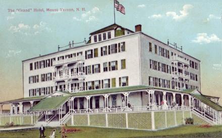
By the late 1890s it had become a tourist town, drawing summer visitors from points south, notably Boston, who escaped the heat in Mont Vernon's hills. At one point it had five large summer hotels, including the Grand Hotel, located on top of Grand Hill.
The hotel business began to wither with the development of the automobile, which allowed tourists to reach places like the White Mountains of New Hampshire, and it was killed by the Great Depression. The town's population bottomed out at barely 300 in 1930, at which time the Grand Hotel was destroyed in a fire. The remaining hotels were torn down before World War II.
Since the war, Mont Vernon has slowly become a suburban community. This was significantly accelerated in 1962-63 when engineers and technicians employed at Sanders Associates in Nashua found homes in Mont Vernon attractive. Some bought dormant farms, some homes in the village. All brought a willingness to pay more taxes to improve the schools. The active farms were squeezed out and eventually only the Pomeroy farm survived. It wasn't until the 1970 census that the town's official population passed mid-19th century highs.
Agriculture, including a 1940s and 1950s boom in chicken and egg farming, has all but disappeared. As of 2008, the town has one dairy farm. For years, the only store in town was the General Store, which closed in January 2010. The store is scheduled to reopen in fall 2011, newly renovated in the style of the 1850s. There are currently a handful of retail and other businesses in the town.[citation needed]
Mont Vernon is also the site where the tragic murder of Kimberly Cates occurred, with her 11 year old daughter Jaimie Cates being stabbed but survived.[2]
Geography
According to the United States Census Bureau, the town has a total area of 16.7 square miles (43 km2), of which 16.6 square miles (43 km2) is land and 0.1 square miles (0.26 km2) is water, comprising 0.48% of the town. Mont Vernon is drained by Beaver Brook and Caesar's Brook. The town's highest point is on its northern border, at 1,015 feet (309 m) above sea level, near the summit of Storey Hill.
Demographics
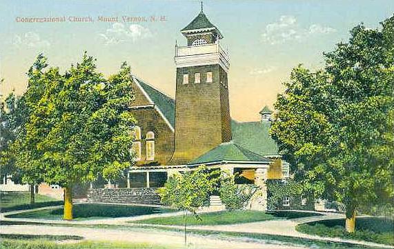
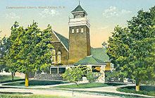 Congregational Church c. 1910
As of the census[3] of 2000, there were 2,034 people, 693 households, and 575 families residing in the town. The population density was 122.4 people per square mile (47.3/km²). There were 720 housing units at an average density of 43.3 per square mile (16.7/km²). The racial makeup of the town was 98.57% White, 0.15% African American, 0.15% Native American, 0.25% Asian, 0.10% from other races, and 0.79% from two or more races. Hispanic or Latino of any race were 0.54% of the population.
There were 693 households out of which 43.3% had children under the age of 18 living with them, 73.7% were married couples living together, 5.6% had a female householder with no husband present, and 16.9% were non-families. 12.1% of all households were made up of individuals and 6.1% had someone living alone who was 65 years of age or older. The average household size was 2.90 and the average family size was 3.17.
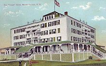 The Grand Hotel in 1909
In the town the population was spread out with 29.7% under the age of 18, 4.4% from 18 to 24, 30.8% from 25 to 44, 26.0% from 45 to 64, and 9.1% who were 65 years of age or older. The median age was 38 years. For every 100 females there were 104.8 males. For every 100 females age 18 and over, there were 103.1 males.
The median income for a household in the town was $71,250, and the median income for a family was $77,869. Males had a median income of $50,353 versus $32,500 for females. The per capita income for the town was $30,772. About 1.0% of families and 2.0% of the population were below the poverty line, including 2.3% of those under age 18 and 5.7% of those age 65 or over.
Town Finances
2005-
Total Tax Rate per thousand: $21.66
NH Ranking (1 is highest tax rate): 59 of 2072006-
Total Tax Rate per thousand: $22.57
NH Ranking (1 is highest tax rate): 32 of 2072007-
Total Tax Rate per thousand: $22.00*
NH Ranking (1 is highest tax rate): 33 of 2072008-
Total Tax Rate per thousand: $23.52
NH Ranking (1 is the highest tax rate): 33 of 2072009-
Total Tax Rate per thousand: $24.30
NH Ranking (1 is the highest tax rate):
*Property reassessment occurred during this year.
In 2006 a bond was defeated in the amount of 2.1 million dollars to rebuild the towns' firehouse.
In 2007 a bond was approved in the amount of 1.5 million dollars to rebuild the firehouse. It was completed in early 2008.Education
The only public school in town is the Mont Vernon Village School. It is an elementary school, with grades kindergarten to sixth. For 7th and 8th grades, Mont Vernon sends its students to the Amherst Middle School. For 9th through 12th grades, the students are sent to Souhegan High School, which is in Amherst but jointly owned by Amherst and Mont Vernon.
Student Teacher Ratio:
2005/2006-
Ratio: 11.6
State Average: 12.9
Enrollment: 2062006/2007-
Ratio: 12.5
State Average: 12.8
Enrollment: 2222007/2008-
Ratio: 14.0
State Average: 12.8
Enrollment: 2262008/2009-
Ration: 12.7
state Average: 12.8
Enrollment: 229The Mont Vernon Fire Department
The former two-story Mont Vernon Fire Station, built in 1947, was located on North Main Street next to the Town Hall. This station had 6 equipment bays. In March 2007 the town voted to raze the deteriorating building and replace it with a new fire station on the same lot. The new station has 5 equipment bays facing North Main Street, and 1 equipment bay facing Pinkham Avenue. The Fire Chief has his office in the station, along with a radio and report room, a meeting room, and an office for the Emergency Management Director. The station also contains maintenance, storage, and work rooms. Emergency medical services are provided by Amherst.
Culture
The town has two major annual celebrations: On the last Saturday in September, it hosts "Lamson Farm Day" at a town-owned farm to celebrate its agricultural past. In late April or early May, it has a celebration of spring called the "Mont Vernon Spring Gala." Both feature games, food and local entertainers and draw hundreds of people.
Sites of interest
- Mont Vernon Historical Society Museum, upstairs in Town Hall
- Purgatory Falls trails along Purgatory Brook
- Mont Vernon General Store
- Lamson Farm
- Horton pond
- Daland Library
References
- ^ United States Census Bureau, American FactFinder, 2010 Census figures. Retrieved March 23, 2011.
- ^ http://www.wmur.com/news/25372919/detail.html
- ^ "American FactFinder". United States Census Bureau. http://factfinder.census.gov. Retrieved 2008-01-31.
External links
- Town website
- Town cemetery website
- Daland Memorial Library
- New Hampshire Economic and Labor Market Information Bureau Profile
- Mont Vernon genealogy, history
Municipalities and communities of Hillsborough County, New Hampshire Cities 
Towns Amherst | Antrim | Bedford | Bennington | Brookline | Deering | Francestown | Goffstown | Greenfield | Greenville | Hancock | Hillsborough | Hollis | Hudson | Litchfield | Lyndeborough | Mason | Merrimack | Milford | Mont Vernon | New Boston | New Ipswich | Pelham | Peterborough | Sharon | Temple | Weare | Wilton | Windsor
Villages East Merrimack | Grasmere | Pinardville
Categories:- Towns in Hillsborough County, New Hampshire
- Populated places established in 1803


Wikimedia Foundation. 2010.