- Litchfield, New Hampshire
Infobox Settlement
official_name = Litchfield, New Hampshire
nickname =
motto =
image_
imagesize =
image_caption =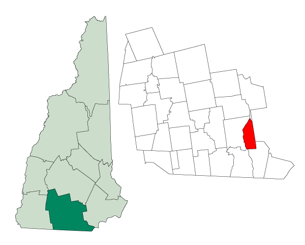
mapsize = 250px
map_caption = Location in Hillsborough County,New Hampshire
settlement_type = Town
mapsize1 =
map_caption1 =
subdivision_type = Country
subdivision_name =United States
subdivision_type1 = State
subdivision_name1 =New Hampshire
subdivision_type2 = County
subdivision_name2 = Hillsborough
government_type =
leader_title =Board of Selectmen
leader_name = Frank Byron, Chairman
Andrew Santom
Alfred Raccio
George Lambert
M. Patricia Jewett
established_title = Incorporated
established_date = 1734
area_magnitude = 1 E8
area_total_km2 = 40.0
area_total_sq_mi = 15.4
area_land_km2 = 39.1
area_land_sq_mi = 15.1
area_water_km2 = 0.9
area_water_sq_mi = 0.3
area_water_percent = 2.27
population_as_of = 2000
population_note =
population_total = 7360
population_density_km2 = 188.2
population_density_sq_mi = 487.5
timezone = Eastern
utc_offset = -5
timezone_DST = Eastern
utc_offset_DST = -4
latd = 42 |latm = 50 |lats = 39 |latNS = N
longd = 71 |longm = 28 |longs = 47 |longEW = W
elevation_m = 39
elevation_ft = 127
website = [http://www.litchfield-nh.gov/ www.litchfield-nh.gov]
postal_code_type =ZIP code
postal_code = 03052
area_code = 603
blank_name = FIPS code
blank_info = 33-42260
blank1_name = GNIS feature ID
blank1_info = 0873648
footnotes =Litchfield is a town in Hillsborough County,
New Hampshire ,United States . The population was 7,360 at the 2000 census, with an estimated population of 8,582 in 2006. [cite web | url = http://www.census.gov/popest/cities/files/SUB-EST2006_33 | title = Subcounty population estimates: New Hampshire 2000-2006| format = CSV | publisher =United States Census Bureau , Population Division | date =2007-06-28 | accessdate =2008-05-28 ]History
Originally known as Naticook, the name was changed to Brenton's Farm in 1729 when the land was granted to William Brenton, colonial governor of
Rhode Island . The town was incorporated in 1734. After Brenton's death in 1749, the land was granted to another group of settlers and named Litchfield after George Henry Lee,Earl of Litchfield .Wiseman Claget moved to his substantial estates here shortly before the Revolution. He was involved in the temporary government serving as the only Solicitor General, the post being abolished shortly before his death in 1784.Geography
According to the
United States Census Bureau , the town has a total area of convert|15.4|sqmi|km2, of which convert|15.1|sqmi|km2|abbr=on is land and convert|0.3|sqmi|km2|abbr=on is water, comprising 2.27% of the town. The highest point in Litchfield is the summit of Rocky Hill, at convert|357|ft|m abovesea level .Demographics
As of the
census GR|2 of 2000, there were 7,360 people, 2,357 households, and 2,031 families residing in the town. Thepopulation density was 487.5 people per square mile (188.2/km²). There were 2,389 housing units at an average density of 158.3/sq mi (61.1/km²). The racial makeup of the town was 97.72% White, 0.53% African American, 0.29% Native American, 0.57% Asian, 0.15% from other races, and 0.75% from two or more races. Hispanic or Latino of any race were 0.83% of the population.There were 2,357 households out of which 53.4% had children under the age of 18 living with them, 75.3% were married couples living together, 7.4% had a female householder with no husband present, and 13.8% were non-families. 9.5% of all households were made up of individuals and 1.4% had someone living alone who was 65 years of age or older. The average household size was 3.12 and the average family size was 3.35.
In the town the population was spread out with 33.4% under the age of 18, 5.4% from 18 to 24, 37.8% from 25 to 44, 19.9% from 45 to 64, and 3.5% who were 65 years of age or older. The median age was 33 years. For every 100 females there were 101.1 males. For every 100 females age 18 and over, there were 98.1 males.
The median income for a household in the town was $73,302, and the median income for a family was $76,931. Males had a median income of $46,809 versus $33,488 for females. The
per capita income for the town was $25,203. About 2.2% of families and 2.1% of the population were below thepoverty line , including 1.6% of those under age 18 and 12.1% of those age 65 or over.Education
There are three public schools in Litchfield:
*Griffin Memorial School (K-4)
*Litchfield Middle School (5-8)
*Campbell High School (9-12); Neighboring cities and townsGeographic Location (8-way)
Centre =
References
External links
* [http://www.litchfield-nh.gov Town website]
* [http://www.nh.gov/nhes/elmi/htmlprofiles/litchfield.html New Hampshire Economic and Labor Market Information Bureau Profile]

Wikimedia Foundation. 2010.