- Merrimack, New Hampshire
-
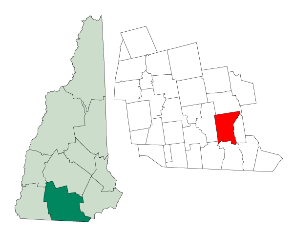
Merrimack, New Hampshire — Town — 
SealLocation in Hillsborough County, New Hampshire
Coordinates: 42°51′59″N 71°29′37″W / 42.86639°N 71.49361°WCoordinates: 42°51′59″N 71°29′37″W / 42.86639°N 71.49361°W Country United States State New Hampshire County Hillsborough Incorporated 1746 Government – Manager Eileen Cabanel – Town council Finlay C. Rothhaus, Chair
William W. Boyd, III, Vice-Chair
Jackie Flood
Daniel Dwyer
Thomas P. Koenig
David Yakuboff, Sr.
Thomas J. MahonArea – Total 33.4 sq mi (86.6 km2) – Land 32.6 sq mi (84.4 km2) – Water 0.8 sq mi (2.1 km2) 2.48% Elevation 180 ft (55 m) Population (2010) – Total 25,494 – Density 763.3/sq mi (294.7/km2) Time zone Eastern (UTC-5) – Summer (DST) Eastern (UTC-4) ZIP code 03054 Area code(s) 603 FIPS code 33-47540 GNIS feature ID 0873663 Website www.merrimacknh.gov Merrimack is a town in Hillsborough County, New Hampshire, United States. The population was 25,494 at the 2010 census, making it the eighth-largest municipality in New Hampshire.[1]
There are four villages in the town: Merrimack Village (formerly known as Souhegan Village), Thornton's Ferry, Reed's Ferry, and South Merrimack.
Contents
History
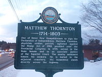
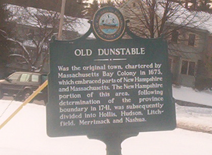
 Historical Marker near Citizens Bank on Daniel Webster Highway stating the town's history before incorporation
Human beings began to settle the area currently known as Merrimack sometime after the recession of the glaciers that had spread over much of New England during the last ice age. European settlers first came to the area in the late 17th century when the area was still in dispute between the Province of New Hampshire and Massachusetts Bay Colony.
Merrimack was officially incorporated in 1746, a year largely regarded as Merrimack's birthday, although only the southern portion (primarily what is known as Thornton's Ferry) of the current boundaries of town was included in the original town, with the northern portion of what is now Merrimack (primarily what is known as Reed's Ferry) being added a few years later.
The Boston and Maine Railroad laid tracks through the town in the 19th century, with several stations operating until the mid-20th century when the advent of the automobile transformed Merrimack from a largely agricultural community to a bedroom community of Boston and nearby cities in New Hampshire. Since 1970 it has been the home of an Anheuser-Busch brewery, their easternmost, and one of their smallest plants in the United States. It is home to a brewery tour and one of the five stables for the Budweiser Clydesdales.[2]
The Merrimack School Board attracted national attention in 1995 when it passed a "prohibition of alternative lifestyle instruction" act, which resulted in the removal of a work by William Shakespeare from the school curriculum.[3] The board members who supported the act were voted out in the subsequent board election.[4]
Notable inhabitants
- Walter Kittredge, Civil War-era musician
- Passaconaway, chieftain in the Pennacook tribe
- Forrest Sherman, admiral in the United States Navy who served as Chief of Naval Operations
- Matthew Thornton, signer of the United States Declaration of Independence
Geography
According to the United States Census Bureau, the town has a total area of 33.4 square miles (87 km2), of which 32.6 sq mi (84 km2) is land and 0.8 sq mi (2.1 km2) (2.48%) is water. The highest point in Merrimack is an unnamed hill in the northwestern part of town that reaches 512 feet (156 m) above sea level.
Areas of Merrimack
Shadows of the former villages that now make Merrimack still exist. However, the boundaries and exact definitions are unclear due to the expansion of suburban development in the town during the latter half of the 20th century.
Thornton's Ferry
The area of town near Naticook Lake and Continental Boulevard, the name of this area comes from Matthew Thornton, one of the signers of the Declaration of Independence who lived in Merrimack and is now buried in a cemetery near the intersection of Daniel Webster Highway (U.S. Route 3) and Greeley Street. Thornton's Ferry Elementary School is located on Camp Sargent Road.
Reed's Ferry
The northern portion of the town, Reed's Ferry is centered around the current intersection of Bedford Road and Daniel Webster Highway. The boundaries of the area are unclear, as the northwestern part of town near Baboosic Lake is not traditionally considered a portion of Reed's Ferry. While as a defined village it was located mostly near the Merrimack River, it may now possibly be seen as part of Reed's Ferry. Reed's Ferry Elementary School is located on Lyons Road.
South Merrimack
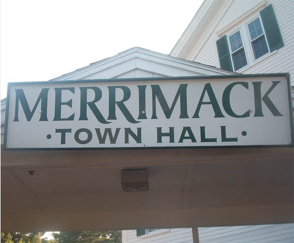
 Next to the Breezeway at Merrimack Town Hall
Centered around Pennichuck Square on Rte. 101A and Continental Boulevard, South Merrimack is usually considered to be the southwestern part of town near Rte. 101A and Boston Post Road. However, the southeastern portion of town near Harris Pond might also be considered part of South Merrimack or Thornton's Ferry.
Merrimack Village
The center of town is not known as "Merrimack Village" per se, but constitutes the area between the more defined Reed's Ferry and Thornton's Ferry areas. Largely considered to be located at the Public Library on the corner of Baboosic Lake Road and Daniel Webster Highway, Merrimack Village was built along the Souhegan River that roughly cuts the current town in half. The elementary school in this part of town is named after James Mastricola,[5] who deeded the land to the town upon his death. The lower and upper elementary schools, the middle school, Merrimack High School, the library, and the current town hall, among other buildings, are all located on the land formerly owned by Mastricola.
The "village" is considered to extend westward to the Amherst border. This is due in large part to the former Town Meetinghouse, which was located on the corner of Turkey Hill Road and Meetinghouse Road.
Neighboring cities and towns

Amherst Bedford Manchester Amherst 
Litchfield  Merrimack

Hollis Nashua Hudson Demographics
For additional demographics on the area of Merrimack east of the Everett Turnpike, see East Merrimack, New Hampshire.As of the census[6] of 2000, there were 25,119 people, 8,832 households, and 6,986 families residing in the town. The population density was 770.6 people per square mile (297.5/km²). There were 8,959 housing units at an average density of 274.8 per square mile (106.1/km²). The racial makeup of the town was 96.58% White, 0.73% African American, 0.19% Native American, 1.50% Asian, 0.04% Pacific Islander, 0.21% from other races, and 0.74% from two or more races. Hispanic or Latino of any race were 1.08% of the population.
There were 8,832 households out of which 41.9% had children under the age of 18 living with them, 68.1% were married couples living together, 7.8% had a female householder with no husband present, and 20.9% were non-families. 15.8% of all households were made up of individuals and 3.8% had someone living alone who was 65 years of age or older. The average household size was 2.84 and the average family size was 3.19.
In the town the population was spread out with 29.0% under the age of 18, 5.8% from 18 to 24, 34.2% from 25 to 44, 24.7% from 45 to 64, and 6.4% who were 65 years of age or older. The median age was 36 years. For every 100 females there were 99.3 males. For every 100 females age 18 and over, there were 96.7 males.
The median income for a household in the town was $68,817, and the median income for a family was $72,011. Males had a median income of $51,725 versus $31,528 for females. The per capita income for the town was $27,748. About 1.2% of families and 1.9% of the population were below the poverty line, including 2.9% of those under age 18 and 3.1% of those age 65 or over.
Economy
PC Connection & Brookstone are based in Merrimack.
Education
The six public schools in Merrimack are managed by the Merrimack School District and include Thorntons Ferry Elementary School, Reeds Ferry Elementary School, James Mastricola Elementary School, James Mastricola Upper Elementary School, Merrimack Middle School and Merrimack High School. In addition, there is a charter school, the Academy for Science and Design, established for the 2007-08 academic year, which is New Hampshire's first charter school to concentrate on science, math, engineering, and design and is free of tuition fees.[7] Merrimack High School has won one state championship in baseball (2007), three in softball (1980, 1988, 2001), one in football (1987), two in soccer (1998 girls, 2007 boys), three in indoor track (1999, 2007, 2008), four in outdoor track (2003, 2004, 2006, 2007), one in cross-country (2006), one in skiing (1979), one in volleyball (2001), and three in basketball (1967, 2003, 2004).[8]
Four schools in Merrimack, along with 174 others statewide, were listed by the New Hampshire Department of Education as "Schools in Need of Improvement" for the 2008-2009 school year.[9][10] However, this cloud was lifted in 2009 and Merrimack is no longer declared as a "District in Need of Improvement".[11]
Politics and governance
Main article: Politics of Merrimack, New HampshireState and federal
As a large, suburban community located directly between the state's two largest cities, Manchester and Nashua, Merrimack plays a disproportionate role to its size every four years in the New Hampshire primary; in almost every Fourth of July preceding a presidential election, every presidential candidate will march or have a float in the town's Fourth of July parade.
Traditionally, in state and national politics, the town has been dominated by Republicans, who currently hold seven of the town's eight seats in the General Court. The current General Court district of Merrimack is Hillsborough 19.
Local
The town government consists of a 7-member Town Council. This form of government was recently adopted by a ballot measure on May 25, 2006. More information on Merrimack's government can be found at Charter commission website.
Each March, the town conducts two deliberative sessions (school and general) to decide what warrant articles will be on the Town General Election ballot in April, one of which is always election of town officers, and another is the budget. If the budget is not approved by the voters, the town's governing council either holds an emergency hearing regarding a new budget or goes forward with the priors years' budget, amended with any time sensitive information pending upon the current year.
The Merrimack Village District administers the water system that serves the central area of the town.
References
- ^ United States Census Bureau, American FactFinder, 2010 Census figures. Retrieved March 23, 2011.
- ^ "Anheuser-Busch Factory Tour in Merrimack, NH". factorytour.com. http://www.factorytour.com/tours/anheuser-busch-merrimack.cfm. Retrieved July 5, 2010.
- ^ Mark Walsh (February 28, 1996). "Gay Students' Request Spurs Board To Cut Clubs". Education Week. http://www.edweek.org/ew/articles/1996/02/28/23gay.h15.html. Retrieved April 7, 2009.
- ^ Rod Paul (May 15, 1996). "New England town rejects religious right; Gays, creationism were hot issues in widely watched school election". The San Francisco Examiner. http://www.sfchroniclemarketplace.com/cgi-bin/article.cgi?f=/e/a/1996/05/15/NEWS15677.dtl&hw=provoked&sn=174&sc=666. Retrieved April 7, 2009.
- ^ "A History of James Mastricola Elementary School". Mastricola Elementary School. Archived from the original on 2007-09-30. http://web.archive.org/web/20070930075918/http://www.merrimack.k12.nh.us/mes/history.htm. Retrieved 2008-03-13.
- ^ "American FactFinder". United States Census Bureau. http://factfinder.census.gov. Retrieved 2008-01-31.
- ^ "New Hampshire May Soon Have a Science and Technology Charter School", Sheryl Rich-Kern, New Hampshire Public Radio, June 18, 2007
- ^ "NHIAA Champions" (PDF). New Hampshire Interscholastic Athletic Association. http://nhiaa.org/PDFs/2602/Champions.pdf. Retrieved 25 February 2010.[dead link]
- ^ "Schools in Need of Improvement (SINI)". New Hampshire Department of Education. August 13, 2008. http://www.ed.state.nh.us/EDUCATION/doe/organization/curriculum/School%20Improvement/SINI/2008-2009SINI/sini.htm. Retrieved April 7, 2009.
- ^ Michael Brindley (August 29, 2007). "191 schools in N.H. fail to meet AYP". The Telegraph. http://www.nashuatelegraph.com/apps/pbcs.dll/article?AID=/20070829/NEWS01/208290362/-1/ARTSANDLIVING. Retrieved April 7, 2009.
- ^ http://www.ed.state.nh.us/education/News/ayp09.htm accessdate=April 7, 2009
External links
- Town website
- Merrimack Community Profile from the Economic and Labor Market Information Bureau
- Merrimack Public Television
- Unofficial Merrimack Town Forum
- Hillsborough County Genealogy and History site on Merrimack
Municipalities and communities of Hillsborough County, New Hampshire Cities 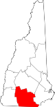
Towns Amherst | Antrim | Bedford | Bennington | Brookline | Deering | Francestown | Goffstown | Greenfield | Greenville | Hancock | Hillsborough | Hollis | Hudson | Litchfield | Lyndeborough | Mason | Merrimack | Milford | Mont Vernon | New Boston | New Ipswich | Pelham | Peterborough | Sharon | Temple | Weare | Wilton | Windsor
Villages East Merrimack | Grasmere | Pinardville
Categories:- Towns in Hillsborough County, New Hampshire
- Populated places established in 1746


Wikimedia Foundation. 2010.