- Peterborough, New Hampshire
Infobox Settlement
official_name = Peterborough, New Hampshire
nickname =
motto =
image_
imagesize =
image_caption =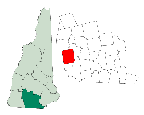
mapsize = 250px
map_caption = Location in Hillsborough County,New Hampshire
settlement_type = Town
mapsize1 =
map_caption1 =
subdivision_type = Country
subdivision_name =United States
subdivision_type1 = State
subdivision_name1 =New Hampshire
subdivision_type2 = County
subdivision_name2 = Hillsborough
government_type =
leader_title =Board of Selectmen
leader_name = Joe Byk, Chairman
Elizabeth Thomas
Barbara Miller
established_title = Incorporated
established_date = 1760
area_magnitude = 1 E8
area_total_km2 = 98.7
area_total_sq_mi = 38.1
area_land_km2 = 97.7
area_land_sq_mi = 37.7
area_water_km2 = 1.1
area_water_sq_mi = 0.4
area_water_percent = 1.08
population_as_of = 2000
population_note =
population_total = 5883
population_density_km2 = 60.2
population_density_sq_mi = 156.0
timezone = Eastern
utc_offset = -5
timezone_DST = Eastern
utc_offset_DST = -4
latd = 42 |latm = 52 |lats = 14 |latNS = N
longd = 71 |longm = 57 |longs = 06 |longEW = W
elevation_m = 219
elevation_ft = 718
website = [http://www.townofpeterborough.com/ www.townofpeterborough.com]
postal_code_type =ZIP code
postal_code = 03458
area_code = 603
blank_name = FIPS code
blank_info = 33-60580
blank1_name = GNIS feature ID
blank1_info = 0873697
footnotes =Peterborough is a town in Hillsborough County,
New Hampshire ,United States . The population was 5,883 at the 2000 census, with an estimated population of 6,100 in 2006. [cite web | url = http://www.census.gov/popest/cities/files/SUB-EST2006_33.csv | title = Subcounty population estimates: New Hampshire 2000-2006| format = CSV | publisher =United States Census Bureau , Population Division | date =2007-06-28 | accessdate =2008-05-28 ]The town center, where over 50% of the population resides, is defined as the Peterborough
census-designated place (CDP), and is located near the intersection ofU.S. Route 202 andNew Hampshire Route 101 along theContoocook River .Geography
According to the
United States Census Bureau , the town has a total area of convert|38.1|sqmi|km2, of which convert|37.7|sqmi|km2|abbr=on is land and convert|0.4|sqmi|km2|abbr=on is water, comprising 1.08% of the town. The highest point in Peterborough isSouth Pack Monadnock Mountain (convert|2290|ft|m|sigfig=3 abovesea level ), inMiller State Park .The town center, or
census-designated place , has a total area of convert|4.8|sqmi|km2|1, of which convert|4.7|sqmi|km2|abbr=on|1 is land and convert|0.04|sqmi|km2|abbr=on|1 (0.42%) is water.Demographics
As of the
census GR|2 of 2000, there were 5,883 people, 2,346 households, and 1,531 families residing in the town. Thepopulation density was 156.0 people per square mile (60.2/km²). There were 2,509 housing units at an average density of 66.5/sq mi (25.7/km²). The racial makeup of the town was 96.97% White, 0.63% Black or African American, 0.15% Native American, 1.29% Asian, 0.03% Pacific Islander, 0.27% from other races, and 0.65% from two or more races. Hispanic or Latino of any race were 0.83% of the population. [ [http://www.nh.gov/oep/programs/DataCenter/Race/index.htm NH Office of State Planning, "Race and Hispanic Data"] , compiled from U.S. Census 2000]There were 2,346 households out of which 32.6% had children under the age of 18 living with them, 51.5% were married couples living together, 11.2% had a female householder with no husband present, and 34.7% were non-families. 28.8% of all households were made up of individuals and 11.9% had someone living alone who was 65 years of age or older. The average household size was 2.37 and the average family size was 2.94.
In the town the population was spread out with 25.1% under the age of 18, 5.0% from 18 to 24, 24.8% from 25 to 44, 24.3% from 45 to 64, and 20.7% who were 65 years of age or older. The median age was 42 years. For every 100 females there were 84.0 males. For every 100 females age 18 and over, there were 77.7 males.
The median income for a household in the town was $47,381, and the median income for a family was $54,375. Males had a median income of $42,178 versus $27,422 for females. The
per capita income for the town was $26,154. About 6.4% of families and 9.1% of the population were below thepoverty line , including 17.0% of those under age 18 and 4.7% of those age 65 or over.Town center
As of the
census GR|2 of 2000, there were 2,944 people, 1,225 households, and 719 families residing in the central village, orcensus-designated place (CDP). Thepopulation density was 621.4 people per square mile (239.8/km²). There were 1,289 housing units at an average density of 272.1/sq mi (105.0/km²). The racial makeup of the CDP was 97.62% White, 0.41% Black or African American, 0.24% Native American, 0.88% Asian, 0.03% Pacific Islander, 0.17% from other races, and 0.65% from two or more races. Hispanic or Latino of any race were 0.78% of the population.There were 1,225 households out of which 28.5% had children under the age of 18 living with them, 43.8% were married couples living together, 12.3% had a female householder with no husband present, and 41.3% were non-families. 34.5% of all households were made up of individuals and 14.4% had someone living alone who was 65 years of age or older. The average household size was 2.21 and the average family size was 2.88.
In the CDP the population was spread out with 22.7% under the age of 18, 5.5% from 18 to 24, 25.3% from 25 to 44, 22.1% from 45 to 64, and 24.3% who were 65 years of age or older. The median age was 43 years. For every 100 females there were 79.1 males. For every 100 females age 18 and over, there were 72.0 males.
The median income for a household in the CDP was $45,313, and the median income for a family was $53,409. Males had a median income of $41,533 versus $28,333 for females. The
per capita income for the CDP was $26,091. About 7.6% of families and 11.1% of the population were below thepoverty line , including 23.7% of those under age 18 and 8.5% of those age 65 or over.Education
The public schools are part of Contoocook Valley school district (SAU 1) which has a total of 11 schools and 1 applied technology center.
*Contoocook Valley Regional High School , built in 1970citation |url=http://www.conval.edu/Schools/CVHS/general/about.html |title=About ConVal High School |accessdate=2007-11-04 |periodical=ConVal School District] , serves approximately 1200 students.
* South Meadow School, founded in 1989citation |url=http://www.conval.edu/Schools/sms/www/Handbook/Handbook.html#history |title=South Meadow School Handbook |accessdate=2007-11-04 |periodical=ConVal School District] , serves approximately 500 students. The school was originally named Peterborough Middle School.
* Peterborough Elementary School, locally known as PES, serves approximately 300 students.
* The town's only private school, The Well School, founded in 1967citation |url=http://www.wellschool.org/podium/default.aspx?t=45518 |title=History of The Well School |periodical=The Well School |accessdate=2007-11-04 ] , serves approximately 200 students, grades Preschool-12.Culture
A rural area of Peterborough has been the location, since its creation in 1907, of the MacDowell
art colony .The town features an institution it calls "First Friday". This tradition has been awarded "Best Community Tradition"Fact|date=December 2007, and is celebrated on the first Friday of each month. In May of every year, Peterborough holds its annual Children and the Arts Day festival. The festival is a chance for local students, ranging in age from preschool to high school and beyond, to exhibit their artistic and creative talents. The celebration lasts all day and consists of the traditional Giant Puppet Parade, as well as the rubber duck race, which goes to benefit local charities. There are also many other activities, including concerts, dancing, and an international food court. Peterborough hosted its fifteenth annual festival on
17 May ,2008 .The Peterborough Town Library is the oldest free
library supported bytax ation in the United States [cite web| url=http://www.bartleby.com/65/li/library.html| title="Library"| publisher=The Columbia Encyclopedia, Sixth Edition, 2001-07 (Bartleby.com)| accessdate=2008-04-15] . It was founded onApril 9 ,1833 , by Unitarian minister Abiel Abbot. The original collection comprised 100 books and was housed in Smith and Thompson's General Store, along with the post office. It later moved to the town hall, and then was given its own building, constructed by local resident John Hopkins Morison, in 1893. The collection now includes over 50,000 volumes. ["American Libraries" April 2008; Vol. 39, No. 4, pg. 24]The Moses Cheney house in Peterborough served as a stop on the
Underground Railroad in the mid 1800s, andFrederick Douglass stayed at the home. Moses' sonOren B. Cheney foundedBates College in 1855, and his sonPerson C. Cheney was aU.S. Senator .The Peterborough Players puts on six plays every summer, having employed such renowned actors as
James Whitmore . In the 2005 season, they performed many outstanding plays such as "Grace and Glorie" and "Little Women".The town was the model for the play "
Our Town ", written byThornton Wilder while in residence at the MacDowell Colony.The film "
The Sensation of Sight " was shot entirely in Peterborough.Club Cannon puts on local rock shows, as well as an annual Battle of the Bands. Its house band is called Your Favorite Color.
Trivia
During
Enron 's initial ramping-up, Peterborough was used as its poster child for proof-of-concept; a full-page New York Times ad, as well as a 30-second Super Bowl spot, were both devoted to Enron's ideas, by way of Peterborough.Peterborough, for some time, was a powerhouse of computer magazine publishing. It was home to such well-known magazines as Byte, AmigaWorld, and A+. Carl Helmers, co-founder of Byte, also launched several vertical-market magazines under the aegis of Helmers Publishing: Supply Chain Manufacturing & Logistics (formerly ID Systems Magazine), Sensors Magazine, Desktop Engineering Magazine, SetiQuest Magazine. The substantial majority of these magazines are now out of print, but Peterborough still retains a heritage of literacy and publishing know-how.
Peterborough is home to one of the oldest basket manufacturers in the country,
Peterboro Basket Company , which has been in business since 1854.References
External links
* [http://www.townofpeterborough.com Town website]
* [http://www.nh.gov/nhes/elmi/htmlprofiles/peterborough.html New Hampshire Economic and Labor Market Information Bureau Profile]
* [http://www.peterboroughchamber.com Greater Peterborough Chamber of Commerce]
Wikimedia Foundation. 2010.