- Holderness, New Hampshire
Infobox Settlement
official_name = Holderness, New Hampshire
nickname =
motto =
image_
imagesize =
image_caption =
mapsize = 250px
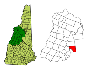
map_caption = Location in Grafton County,New Hampshire
settlement_type = Town
mapsize1 =
map_caption1 =
subdivision_type = Country
subdivision_name =United States
subdivision_type1 = State
subdivision_name1 =New Hampshire
subdivision_type2 = County
subdivision_name2 = Grafton
government_type =
leader_title =Board of Selectmen
leader_name = Peter Webster, Chairman
Barbara Currier
Sidney Lovett
Suzanne Peoples
Christopher Devine
established_title = Incorporated
established_date = 1761
named_for =Robert Darcy, 4th Earl of Holderness
area_magnitude = 1 E8
area_total_km2 = 93.0
area_total_sq_mi = 35.9
area_land_km2 = 79.0
area_land_sq_mi = 30.5
area_water_km2 = 14.0
area_water_sq_mi = 5.4
area_water_percent = 13.97
population_as_of = 2000
population_note =
population_total = 1930
population_density_km2 = 24.5
population_density_sq_mi = 63.5
timezone = Eastern
utc_offset = -5
timezone_DST = Eastern
utc_offset_DST = -4
latd = 43 |latm = 43 |lats = 52 |latNS = N
longd = 71 |longm = 35 |longs = 18 |longEW = W
elevation_m = 178
elevation_ft = 584
website = [http://www.holderness-nh.gov/ www.holderness-nh.gov]
postal_code_type =ZIP code
postal_code = 03245
area_code = 603
blank_name = FIPS code
blank_info = 33-36900
blank1_name = GNIS feature ID
blank1_info = 0873627
footnotes =Holderness is a town in Grafton County,
New Hampshire ,United States . The population was 1,930 at the 2000 census. An agricultural and resort area, Holderness is home to theSquam Lakes Natural Science Center and is located onSquam Lake . Holderness is also home toHolderness School , a prestigious co-educational college-preparatory boarding school.History
The Squam Lakes were a trade route for
Abenaki Indians and earlyEurope an settlers, who traveled theSquam River to thePemigewasset River , then to theMerrimack River and seacoast. In 1751, Thomas Shepard submitted a petition on behalf of 64 grantees to Colonial GovernorBenning Wentworth for 6 miles square on the Pemigewasset River. The governing council accepted, and the town was named "Holderness" after Robert Darcy, 4th Earl of Holderness. The terrors of theFrench and Indian War , however, prevented settlement until after theFall of Quebec in 1759. The land was regranted as "New Holderness" in 1761 to a group ofNew England families, and first settled in 1763. As proprietor of half the town,Samuel Livermore intended to create at "New Holderness" a great estate patterned after those of the English countryside. By 1790, the town had 329 residents, and in 1816, "New" was dropped from its name.Holderness became a
farming andfishing community, except for the "business or flat iron area" located on the Squam River, which has falls that drop about 112 feet before meeting the Pemigewasset River. Withwater power to operate mills, the southwestern corner of town developed into an industrial center, to which the Boston, Concord & Montreal Railroad entered in 1849. But the mill village would be at odds with the agricultural community, especially when denied civic amenities including gaslights and sidewalks. Consequently, in 1868, it was set off as Ashland.Tourists in the 19th century discovered the region's scenic mountains and lakes. Before the age of
automobile s, they would depart thetrain in Ashland and board a steamer, which traveled up the Squam River to rustic fishing camps or hillside hotels beside Squam Lake. Today, Holderness remains a popular resort area, where in 1981 the movie "On Golden Pond" was filmed.Notable inhabitants
*
Joan Blos , writer (seasonal resident)
*Oren B. Cheney , founder ofBates College
*Arthur Livermore (1766-1853), aUnited States Representative from New Hampshire
*Samuel Livermore (1732-1803),U.S. Senator
*Hercules Mooney , Revolutionary War officer
* George Butler, director of documentaries such as "Pumping Iron ", "The Endurance " (part resident)Geography
According to the
United States Census Bureau , the town has a total area of convert|35.6|sqmi|km2, of which convert|30.4|sqmi|km2|abbr=on is land and convert|5.2|sqmi|km2|abbr=on is water, comprising 14.73% of the town. Bounded on the northwest by thePemigewasset River , Holderness is drained by Owl Brook. Part ofSquam Lake is in the east, andLittle Squam Lake is in the center. Mount Prospect, with an elevation of convert|2064|ft|m abovesea level , is in the north. Also in the north is the highest point in Holderness, Mount Webster, elevation convert|2076|ft|m and part of the Squam Range. Holderness lies fully within theMerrimack River watershed.cite book |title=Water Use in New Hampshire: An Activities Guide for Teachers |url=http://nh.water.usgs.gov/Publications/nh.intro.html |last=Foster |first=Debra H. |coauthors=Batorfalvy, Tatianna N.; and Medalie, Laura |publisher=U.S. Department of the Interior and U.S. Geological Survey |year=1995]Demographics
As of the
census GR|2 of 2000, there were 1,930 people, 768 households, and 546 families residing in the town. Thepopulation density was 63.5 people per square mile (24.5/km²). There were 1,208 housing units at an average density of 39.8/sq mi (15.4/km²). The racial makeup of the town was 97.88% White, 0.47% African American, 0.05% Native American, 0.36% Asian, 0.10% from other races, and 1.14% from two or more races. Hispanic or Latino of any race were 0.41% of the population.There were 768 households out of which 30.7% had children under the age of 18 living with them, 61.2% were married couples living together, 5.9% had a female householder with no husband present, and 28.9% were non-families. 21.5% of all households were made up of individuals and 7.3% had someone living alone who was 65 years of age or older. The average household size was 2.48 and the average family size was 2.91.
In the town the population was spread out with 24.4% under the age of 18, 6.9% from 18 to 24, 24.5% from 25 to 44, 31.4% from 45 to 64, and 12.8% who were 65 years of age or older. The median age was 42 years. For every 100 females there were 95.9 males. For every 100 females age 18 and over, there were 98.8 males.
The median income for a household in the town was $47,895, and the median income for a family was $55,526. Males had a median income of $36,500 versus $26,116 for females. The
per capita income for the town was $27,825. About 2.8% of families and 4.9% of the population were below thepoverty line , including 9.2% of those under age 18 and 4.0% of those age 65 or over.Town government
Holderness is governed in the traditional New England style, with a 5-member board of selectmen as its executive branch, and the traditional
Town Meeting as its legislative branch. Municipal elections and Town Meetings are customarily held in March.References
External links
* [http://www.holderness-nh.gov Town website]
* [http://www.rootsweb.com/~nhgrafto/ Holderness Historical Society]
* [http://www.nh.gov/nhes/elmi/htmlprofiles/holderness.html New Hampshire Economic and Labor Market Information Bureau Profile]
* [http://www.nhnature.org/ Squam Lakes Natural Science Center]Geographic Location
Centre = Holderness
North = Campton
Northeast = Sandwich
East = Sandwich/Center Harbor
Southeast = Center Harbor
South = New Hampton
Southwest = Ashland
West = Plymouth
Northwest = Campton

Wikimedia Foundation. 2010.