- Farmington, New Hampshire
Infobox Settlement
official_name = Town of Farmington
nickname =
motto =
imagesize =
image_caption =
image_
mapsize = 250px
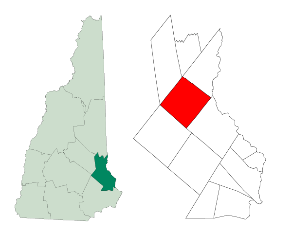
map_caption = Location withinStrafford County ,New Hampshire
settlement_type = Town
mapsize1 =
map_caption1 =
subdivision_type = Country
subdivision_name =United States
subdivision_type1 = State
subdivision_name1 =New Hampshire
subdivision_type2 = County
subdivision_name2 = Strafford
government_type =
leader_title =
leader_name =
established_title = Settled
established_title2 = Incorporated
established_date = 1770s
established_date2 =
area_magnitude =
area_total_sq_mi = 20.2
area_total_km2 = 52.2
area_land_sq_mi = 20.0
area_land_km2 = 51.7
area_water_sq_mi = 0.2
area_water_km2 = 0.5
area_urban_sq_mi =
area_urban_km2 =
area_metro_sq_mi =
area_metro_km2 =
population_as_of = 2007
population_note =
population_total = 6,661
population_metro =
population_urban =
population_density_km2 = 128.8
population_density_sq_mi = 333.1
timezone = EST
utc_offset = -5
timezone_DST = EDT
utc_offset_DST = -4
latd = 43 |latm = 23 |lats = 23 |latNS = N
longd = 71 |longm = 03 |longs = 56 |longEW = W
elevation_m = 87
elevation_ft = 285
website = [http://www.farmington.nh.us/ www.farmington.nh.us]
postal_code_type =ZIP code
postal_code = 03835
area_code = 603
blank_name = FIPS code
blank_info = 33-26020
blank1_name = GNIS feature ID
blank1_info = 0873596
footnotes = Farmington is a town located in Strafford County,New Hampshire ,USA . The 2000 census reported that the town had a total population of 5,774. The 2006 population was estimated to be 6,817. [cite web|url=http://www.nh.gov/oep/programs/DataCenter/Population/documents/pub06.pdf|title=2006 Population Estimates of New Hampshire Cities and Towns|publisher=NH Office of Energy and Planning|accessdate=2008-03-11] Farmington is home to Blue Job State Forest.The compact town center, where over 60% of the town's population resides, is defined by the U.S. Census Bureau as a
census-designated place and is located at the junction of New Hampshire Routes 75 and 153.History
The
Abenaki Indians once used theCochecho River for transportation, and had a camping ground on Meetinghouse Hill, where they builtbirch bark canoes. Otherwise, the valley waswilderness , through which Indians from the north traveled after crossingLake Winnipesaukee on their way to raid settlements in and around Dover. To stop the raids, in 1721 the Colonial Assembly in Portsmouth approved construction of a fort at the foot of the lake, with a "soldiers' road" built from Dover to supply it. In 1722, "Bay Road" -- old Route 11 -- was surveyed and completed. Along its course the town of Farmington would grow.The settlement began as the "Northwest Parish" of Rochester, which was chartered in 1722. The last Indian attack in the general region occurred in 1748, but by 1749, Native Americans had disappeared from
war fare anddisease . Farmers cultivated the rocky soil, andgristmill s used streams forwater power to grind their grain.Sawmill s cut the abundanttimber , and the first frame house at the village was built in 1782. In 1790, Jonas March from Portsmouth established a store, behind which he instructed teamsters to unload on his "dock" the lumber he traded. The area became known as "March's Dock," "Farmington Dock," and finally just "The Dock."Inhabitants of the Northwest Parish were taxed to support both the meetinghouse and minister about 12 miles away on Rochester Hill, but the distance made attendance difficult. A movement began in the 1770s to establish a separate township, and in 1783 a petition for charter was submitted to the state legislature. It was denied, but another petition in 1798 was granted. Containing about 1,000 inhabitants, "Farmington" was incorporated. In 1800, a 40 by 50 foot, 2 story meetinghouse was erected on Meetinghouse Hill. The same year, John Wingate established a
blacksmith y. He would also become proprietor of Wingate's Tavern.In the 19th century, the community developed a prime shoe-making industry, and was one of the first places to use automated machines instead of handwork. In 1836, shoe-manufacturing began at a shop on Spring Street built by E.H. Badger, although it was soon abandoned to creditors. Martin Luther Hayes took over the business, and by 1840 was successful enough to enlarge the handsome
Greek Revival building. The town would be connected byrailroad to Dover in 1849, the line extended to Alton Bay in 1851. Shoes were shipped to Boston to be sold at semi-annual auctions for 50 cents a pair.Following the Civil War, the shoe business boomed and numerous factories were built. Despite a fire in 1875 which destroyed much of the center of town, Farmington was known as "The Shoe Capital of New Hampshire." Other factories produced knives, knit underwear, wooden boxes, wooden handles and
carriage s.Brush es were manufactured by the F.W. Browne Co., from whichBooker T. Washington ordered 12 street brooms in 1915 for use at theTuskegee Institute . The town had 5 blacksmith shops. But the Depression of 1893 closed all but 2 large shoe factories. The industry faded in the 20th century, when most of the town's factories were demolished. One shoe factory would find new use as an antique shop. Another antique store opened in the brush factory, itself the historic Badger-Hayes Shoe Shop. Today, the major industry in Farmington isCollins & Aikman , located on Route 11.Notable residents
*
Nehemiah Eastman (1782 - 1856), lawyer & congressman
*Joseph Hammons (1787 - 1836),United States Representative from New Hampshire
*Alonzo Nute (1826 - 1892), United States Representative from New Hampshire
*Hannah Wilson , (1787 - 1869), master weaver
*Henry Wilson , U.S. vice-presidentGeography
According to the
United States Census Bureau , the town has a total area of convert|37.5|sqmi|km2, of which convert|37.2|sqmi|km2|abbr=on is land and convert|0.3|sqmi|km2|abbr=on is water, comprising 0.88% of the town. The town center (census-designated place ) has a total area of convert|6.4|sqmi|km2|abbr=on, all of it land.Farmington is drained by the
Ela River , Mad River andCochecho River . Part of the Blue Hills Range,foothills of the White Mountains, is in the southwest. The highest point in Farmington is Blue Job Mountain, at convert|1350|ft|m abovesea level . Farmington lies almost fully within thePiscataqua River (Coastal) watershed, with the westernmost corner of town located in theMerrimack River watershed.cite book |title=Water Use in New Hampshire: An Activities Guide for Teachers |url=http://nh.water.usgs.gov/Publications/nh.intro.html |last=Foster |first=Debra H. |coauthors=Batorfalvy, Tatianna N.; and Medalie, Laura |publisher=U.S. Department of the Interior and U.S. Geological Survey |year=1995]Demographics
In 2003, an examination of building permits by a subcommittee of the Farmington Planning Board showed that the town's population had been undercounted in the 2000 U.S. census by about 9%. Town planning documents were subsequently corrected to use an estimated 2000 population of 6,303. This changed the number of households to 2,343 households, the population density to 65/km² (168/sq mi) and the density of households to 24.1/km² (62.5/sq mi). The number of families was not calculated. [cite web|url=http://www.farmington.nh.us/Public_Documents/FarmingtonNH_BComm/planning|title=Farmington Planning Board|accessdate=2008-03-11]
In addition to counting population, the 2000 Census also sets forth population and housing characteristics including rent levels, income, and housing type. This data is based on sampling statistics, meaning that the results are derived from a cross-section of the town's total population, so despite the undercount, these figures may be considered accurate.
The racial makeup of the town is 98.20% White, 0.03%
African American , 0.43% Native American, 0.12%Asia n, 0.00% Pacific Islander, 0.21% from other races, and 1.00% from two or more races. 1.00% of the population areHispanic orLatino of any race.There are 2,343 households (2,146 households by 2000
Census ) out of which 37.2% have children under the age of 18 living with them, 53.9% are married couples living together, 11.4% have a woman whose husband does not live with her, and 28.8% are non-families. 21.3% of all households are made up of individuals and 7.8% have someone living alone who is 65 years of age or older. The average household size is 2.68 and the average family size is 3.09.In the town the population is spread out with 28.1% under the age of 18, 7.2% from 18 to 24, 31.0% from 25 to 44, 23.4% from 45 to 64, and 10.3% who are 65 years of age or older. The median age is 36 years. For every 100 females there are 98.6 males. For every 100 females age 18 and over, there are 96.1 males.
The median income for a household in the town is $40,971, which is 9% below the county average, and 17% below the state average. The median income for a family is $44,788. Males have a median income of $32,320 versus $24,527 for females. The per capita income for the town is $16,574. 9.5% of the population and 6.3% of families are below the poverty line. Out of the total people living in poverty, 8.1% are under the age of 18 and 11.2% are 65 or older.
Although the town has about the same percentage of population below the poverty line as does the county, the town has a disproportionate share of the county’s low income residents living just above the poverty line, and a disproportionately small share of the county’s affluent households. This means that with changing socio-economic pressures, a larger portion of town's population is at risk of falling into poverty than is the case elsewhere in the county.
Town center
As of the
census of 2000, there were 3,468 people, 1,332 households, and 904 families residing in the densely-populated center of town, orcensus-designated place (CDP). Thepopulation density was 541.6 people per square mile (209.2/km²). There were 1,440 housing units at an average density of 86.9 persons/km² (224.9 persons/sq mi). The racial makeup of the community was 98.13% White, 0.00%African American , 0.55% Native American, 0.12%Asia n, 0.26% from other races, and 0.95% from two or more races. 1.10% of the population wereHispanic orLatino of any race.There were 1,332 households out of which 36.6% had children under the age of 18 living with them, 48.2% were married couples living together, 13.5% have a woman whose husband does not live with her, and 32.1% were non-families. 25.4% of all households were made up of individuals and 10.1% had someone living alone who was 65 years of age or older. The average household size was 2.59 and the average family size was 3.07.
In the community the population was spread out with 28.5% under the age of 18, 7.9% from 18 to 24, 30.2% from 25 to 44, 21.7% from 45 to 64, and 11.6% who were 65 years of age or older. The median age was 35 years. For every 100 females there were 98.1 males. For every 100 females age 18 and over, there were 93.0 males.
The median income for a household in the village area was $35,313, and the median income for a family was $39,931. Males had a median income of $31,952 versus $24,617 for females. The
per capita income for the community was $15,048. 12.7% of the population and 8.8% of families were below the poverty line. Out of the total people living in poverty, 11.0% are under the age of 18 and 15.3% are 65 or older.References
Further reading
* The Bicentennial History Committee, "The History of Farmington, NH, from the Days of the Northwest Parish to the Present Time", The Foster Press, Farmington, NH 1976
External links
* [http://www.farmington.nh.us/Public_Documents/index Farmington, New Hampshire "Official Website"]
* [http://www.museumsusa.org/museums/info/1163505 Farmington Historical Society Museum]
* [http://www.goodwinlibrary.com/ Goodwin Library]
* [http://www.nh.gov/nhes/elmi/htmlprofiles/farmington.html New Hampshire Economic and Labor Market Information Bureau Profile]
Wikimedia Foundation. 2010.