- Whitefield, New Hampshire
Infobox Settlement
official_name = Whitefield, New Hampshire
nickname =
motto =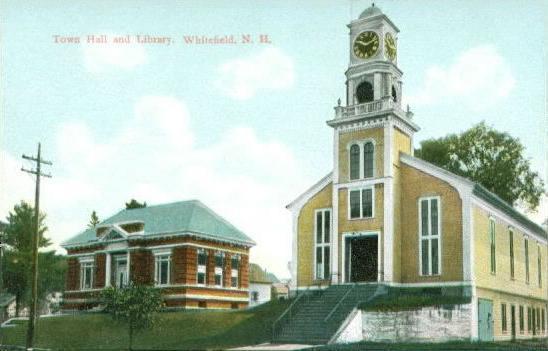
image_
imagesize =
image_caption =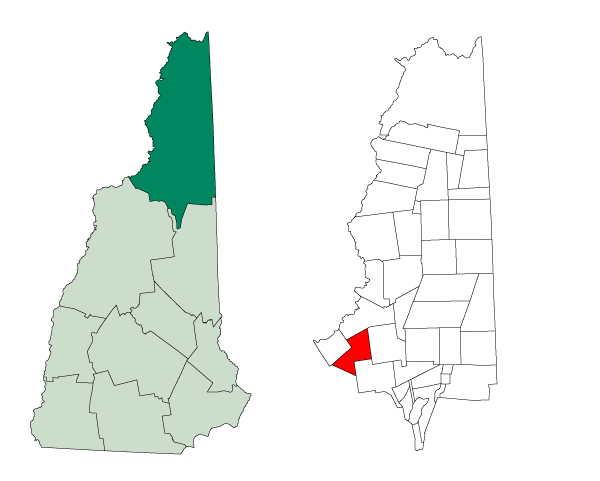
mapsize = 250x200px
map_caption = Location inCoos County, New Hampshire
settlement_type = Town
mapsize1 =
map_caption1 =
subdivision_type = Country
subdivision_name =United States
subdivision_type1 = State
subdivision_name1 =New Hampshire
subdivision_type2 = County
subdivision_name2 = Coos
government_type =
leader_title =Board of Selectmen
leader_name = Kenneth Jordan, Jr.
Wendy Hersom
Jay Hartnett
established_title = Incorporated
established_date = 1804
area_magnitude = 1 E8
area_total_km2 = 89.8
area_total_sq_mi = 34.7
area_land_km2 = 88.7
area_land_sq_mi = 34.2
area_water_km2 = 1.1
area_water_sq_mi = 0.4
area_water_percent = 1.24
population_as_of = 2000
population_note =
population_total = 2038
population_density_km2 = 23.0
population_density_sq_mi = 59.5
timezone = Eastern
utc_offset = -5
timezone_DST = Eastern
utc_offset_DST = -4
latd = 44 |latm = 22 |lats = 24 |latNS = N
longd = 71 |longm = 36 |longs = 44 |longEW = W
elevation_m = 289
elevation_ft = 948
website = [http://www.whitefieldnh.org/ www.whitefieldnh.org]
postal_code_type =ZIP code
postal_code = 03598
area_code = 603
blank_name = FIPS code
blank_info = 33-84420
blank1_name = GNIS feature ID
blank1_info = 0873754
footnotes =Whitefield is a town in Coos County,
New Hampshire ,USA , in theWhite Mountains Region . The population was 2,038 at the 2000 census. Situated on the northern edge of the White Mountains, Whitefield is home to theMount Washington Regional Airport and the White Mountains Regional High School.Whitefield is part of the Berlin, NH–VT Micropolitan Statistical Area. The central village in the town, where over 53% of the population resides, is defined as the Whitefield
census-designated place (CDP) and is located at the junction ofU.S. Route 3 ,New Hampshire Route 116 and NH Route 142.History
The last town to be granted under the English provincial government, Whitefield was chartered on
July 4 ,1774 , exactly two years before adoption of theDeclaration of Independence . Some believe it was named forGeorge Whitefield , a famous English evangelist, and a friend ofWilliam Legge, 2nd Earl of Dartmouth , the patron ofDartmouth College . Others believe the name originated from earlier references to the snowy white fields one would see upon approach through any of the surrounding mountain passages. The chartered name was "Whitefields" but the "s" was dropped on December 1, 1804-- the date of incorporation. Early grantees includedJeremy Belknap , historian, andJohn Langdon , who succeeded John Wentworth as governor.Whitefield has many fine examples of
Victorian architecture , including a landmarkbandstand built in 1875 on the picturesque common. With the entrance of therailroad in the19th century , tourists discovered the town and its cool, clean mountain air. They sought relief from the heat, humidity and pollution of coal-era summers in Boston, Hartford, New York andPhiladelphia . Several inns and hotels were built to accommodate their increasing numbers. On a hilltop facing thePresidential Range is the grandest, The Mountain View House, established in 1866. The historic hotel recently underwent an expensive renovation, and is now one of the most luxurious in New Hampshire.Geography
According to the
United States Census Bureau , the town has a total area of convert|34.7|sqmi|km2|lk=on, of which convert|34.2|sqmi|km2|abbr=on is land and convert|0.4|sqmi|km2|abbr=on, or 1.24%, is water. Whitefield is drained by Bog Brook and the Johns River, which runs through the center of town. Forest Lake and the Forest Lake State Park are located along Route 116, west of the town center.The two highest points in Whitefield are Howland Hill and Kimball Hill, both of which top convert|1712|ft|m|lk=on above
sea level .The central village of Whitefield, a
census-designated place , has a total area of convert|1.3|sqmi|km2|abbr=on.Demographics
As of the
census of 2000, there were 2,038 people, 819 households, and 547 families residing in the town. Thepopulation density was 59.5 people per square mile (23.0/km²). There were 1,158 housing units at an average density of 13.1 persons/km² (33.8 persons/sq mi). The racial makeup of the town was 98.09% White, 0.20%African American , 0.34% Native American, 0.34%Asia n, 0.00% Pacific Islander, 0.29% from other races, and 0.74% from two or more races. 1.13% of the population wereHispanic orLatino of any race.There were 819 households out of which 32.0% had children under the age of 18 living with them, 53.2% were married couples living together, 9.4% have a woman whose husband does not live with her, and 33.2% were non-families. 27.1% of all households were made up of individuals and 13.3% had someone living alone who was 65 years of age or older. The average household size was 2.40 and the average family size was 2.90.
In the town the population was spread out with 24.3% under the age of 18, 7.5% from 18 to 24, 26.0% from 25 to 44, 23.7% from 45 to 64, and 18.5% who were 65 years of age or older. The median age was 40 years. For every 100 females there were 89.9 males. For every 100 females age 18 and over, there were 90.1 males.
The median income for a household in the town was $34,583, and the median income for a family was $41,528. Males had a median income of $29,293 versus $21,378 for females. The
per capita income for the town was $17,070. 9.8% of the population and 6.1% of families were below the poverty line. Out of the total people living in poverty, 9.8% are under the age of 18 and 13.5% are 65 or older.Town center
As of the
census of 2000, there were 1,089 people, 433 households, and 272 families residing in the central village of Whitefield, acensus-designated place . Thepopulation density was 845.9 people per square mile (325.9/km²). There were 525 housing units at an average density of 157.1 persons/km² (407.8 persons/sq mi). The racial makeup of the town was 98.26% White, 0.37%African American , 0.18% Native American, 0.09%Asia n, and 1.10% from two or more races. 0.64% of the population wereHispanic orLatino of any race.There were 433 households out of which 32.1% had children under the age of 18 living with them, 48.3% were married couples living together, 10.2% have a woman whose husband does not live with her, and 37.0% were non-families. 31.2% of all households were made up of individuals and 17.6% had someone living alone who was 65 years of age or older. The average household size was 2.36 and the average family size was 2.95.
In the CDP the population was spread out with 24.2% under the age of 18, 8.7% from 18 to 24, 26.1% from 25 to 44, 19.5% from 45 to 64, and 21.5% who were 65 years of age or older. The median age was 39 years. For every 100 females there were 83.6 males. For every 100 females age 18 and over, there were 84.2 males.
The median income for a household is $31,071, and the median income for a family was $38,750. Males had a median income of $28,068 versus $20,375 for females. The
per capita income for the town was $16,217. 10.3% of the population and 7.1% of families were below the poverty line. Out of the total people living in poverty, 11.7% are under the age of 18 and 17.9% are 65 or older.Sites of interest
* Old Mill Studio
* Whitefield Historical Society Museum
* The Weathervane TheatreExternal links
* [http://www.whitefieldnh.org/ Whitefield, NH "Official Website"]
* [http://www.mountainviewgrand.com/new-hampshire-historic-resorts.html History of The Mountain View House]
* [http://www.wildnh.com/Inside_FandG/hatcheries_visitor_centers.htm Twin Mountain Fish Hatchery, Whitefield]
* [http://www.nh.gov/nhes/elmi/htmlprofiles/whitefield.html New Hampshire Economic and Labor Market Information Bureau Profile]
Wikimedia Foundation. 2010.